

California map
Tulare map
About 72,601 people live here (Census Bureau, 2024 estimate). The sheet's index lists 300 streets; Golden State Highway, North M Street and East Tulare Avenue cross the most grid squares. Things to do inside the boundary: Tulare Outlet Center.
Open the map (PDF, US Letter)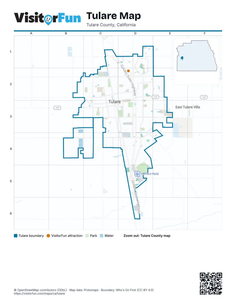
Street index of Tulare
Each street on the sheet and the grid squares it crosses.
- Golden State HighwayC1, D1, D2, D3, D4, D5
- Mooney BoulevardE1, E2
- East Tulare AvenueD2, E2, C3, D3
- West Inyo AvenueB3, C3
- East Inyo AvenueC3, D3
- South M StreetD3
- South Laspina StreetD2, D3, D4, D5
- South K StreetC3, D3, D4, D5
- East Prosperity AvenueC2, D2, E2
- East Cartmill AvenueC1, D1, E1
- South I StreetC3, D3, D4
- North J StreetC1, C2, C3
- West Paige AvenueB4, C4, D4
- East Bardsley AvenueD3, E3
- South Blackstone StreetD2, D3, D4
- North Hillman StreetD1, D2
- South Mooney BoulevardE2, D3, E3
- West Tulare AvenueC2, C3
- South O StreetD2, D3
- West Prosperity AvenueC2
- North Blackstone StreetD2
- West Cartmill AvenueC1
- South J StreetC3, D3
- East Foster DriveD3, D4
- Turner DriveD4, E4
- East Rankin RoadD5
- Road 108D1
- J StreetC1
- Morrison StreetE2, E3
- East Cross AvenueC2, D2, E2
- Paseo Del LagoD1, D2
- North M StreetC1, D1, C2, D2, D3
- West Bardsley AvenueC3, D3
- North E StreetC1, C2, C3
- North Laspina StreetD1, D2
- North Oaks StreetC1, D1, C2
- North West StreetC2, C3
- South E StreetC3
- West Cross AvenueC2
- Enterprise StreetB3, B4
- South West StreetC3, C4
- East Alpine AvenueD3, E3
- South Pratt StreetC3, C4
- Hosfield DriveD5
- East Paige AvenueD4
- Tex DriveD4, D5
- Avenue 184D6
- South Oakmore StreetE3
- South Enterprise StreetB4
- M StreetC1
- East Kern AvenueC3, D3
- West Pleasant AvenueB2, C2
- North Gem StreetD2
- South Spruce StreetD2, D3
- West Sonora AvenueB3, C3
- East Walnut AvenueD3
- East Levin AvenueD3
- North Sacramento StreetC2, C3
- North F StreetC2, C3
- North H StreetC2, C3
- East Academy AvenueD2
- North Cherry StreetD2
- West Kern AvenueC3
- West San Joaquin AvenueC2
- East San Joaquin AvenueC2, D2
- West Elm AvenueC3
- East Sonora AvenueC3, D3
- East Sierra AvenueD2, E2, E3
- West Owens AvenueB3, C3
- Nelder Grove StreetE3
- South Latimer StreetD2, D3
- West King AvenueC2, C3
- East Merritt AvenueC2, D2
- Martin Luther King Junior AvenueC3, D3
- East Pleasant AvenueC2, D2
- North A StreetC2, C3
- East Ash AvenueD3
- West Maple AvenueC2
- North Milner StreetC2
- North G StreetC2, C3
- East Ben Franklin AvenueD2
- South H StreetC3
- South R StreetD3
- North I StreetC2, C3
- Bella Oaks DriveD1, E1
- Retherford StreetD1, D2
- South F StreetC3
- South Dayton StreetD3
- West Alpine AvenueC3
- South D StreetC3
- West Gail AvenueC2
- South Irwin StreetD3
- Maricopa StreetC2, C3
- South C StreetC3
- South Santa Clara StreetC3
- South Sacramento StreetC3
- Washington AvenueC1, C2, D2
- Stockham AvenueD3
- Catalina AvenueB2, C2
- La Dawna StreetB2
- Corvina AvenueD1, D2
- North O StreetD2
- Avenue 208B4
- North N StreetD2, D3
- South G StreetC3
- Seaside AvenueE3
- South Los Angeles StreetC3
- South Aronian StreetD2, D3
- North Denair StreetC2
- East Sandalwood AvenueD2
- North D StreetC2, C3
- Martinho AvenueB2, C2
- Betsy AveC3
- North B StreetC2, C3
- Sunrise StreetD4, E4
- De La Vina StreetD1
- North Dickram DriveC2
- East Continental AvenueD3
- South Ametjian StreetD2, D3
- East Cypress AvenueD3
- South Q StreetD3
- Diamante DriveD1
- South Moraine StreetD2, D3
- East Estate DriveC2, D2
- North Lynora StreetD2
- Chevy Chase DriveC2, D2
- N PlaceC2, D2
- Tahoe AvenueD4, E4
- West Merritt AvenueB2, C2
- South Silva StreetD2, D3
- West Oakland AvenueC2
- East Hillcrest AvenueD2
- Belmont StreetC2
- East Gail AvenueC2, D2
- East Sandra AvenueC2, D2
- East Apricot AvenueD2
- East King AvenueC2, D2
- Bright StreetD4, E4
- East Elm AvenueD3
- East Cedar AvenueD3
- East College AvenueC2, D2
- Presidential DriveC1
- Clinton AvenueB4, C4
- East Sycamore AvenueD2, E2
- Commercial AvenueD4, E4
- South L StreetC3, D3
- Bell Port AvenueE3
- North L StreetC2, C3
- South Cardoza StreetD3
- Montana de Oro StreetE2, E3
- Solaria StreetD1, D2
- Leland AvenueD2
- North Beatrice DriveC2
- North Highland StreetD2
- Seminole AvenueE2
- East Coelho AvenueD2
- Alpha StreetB2, C2
- Firestone DriveD2
- East Bridger AvenueD3
- Industrial AvenueD4
- Gemini StreetB3
- Harbor Island AvenueE3
- Ship Rock AvenueE3
- Muirfield AvenueE2
- West Cedar AvenueC3
- South Howard StreetC3
- South P StreetD3
- South Larkin StreetC3
- East Finch AvenueD2
- La Paloma DriveD1
- Hampton StreetE2, E3
- Peggy StreetD3
- North Petaluma StreetC2
- South U StreetD3
- South T StreetD3
- North Lincoln StreetD2
- Marion StreetD3
- North Auburn StreetD2
- North Manor DriveD2
- East Lyndale DriveD2
- Vetter DriveC3
- Jackson AvenueC1, D1
- West Shasta AvenueC3
- Monsecco StreetD1, D2
- Windsong DriveE3
- North K StreetC2, C3
- North Brentwood StreetD2
- Cape Canyon AvenueE3
- Kern AvenueE3
- Rhen DrE2
- Bolton AvenueD1
- Edgewater StreetE3
- East Eastbrook AvenueD3
- West Beaumont AvenueC2
- Dorset StreetD1
- Cochran AvenueB2, C2
- Hatch AvenueB2, C2
- East Birch AvenueD3
- West Tyson AvenueB2, C2
- East Sequoia AvenueD3
- Kelty Meadows AvenueE3
- Hermosa AvenueB2, C2
- Elsinore StreetD4
- North Delwood StreetD2
- North Mountain View StreetD2
- South Kazarian StreetD3
- South Mark StreetD3
- Tuolumne AvenueE4
- East Owens AvenueC3, D3
- Yellowstone StreetC3
- Alcott StreetC1, C2
- East Wilson AvenueC1, D1
- West Madalyn AvenueC2
- North Jefferson StreetD2
- Cardoza DriveD3
- West Camron AvenueC2
- East Kohn AvenueD3
- North California StreetC2, C3
- Seymour StreetD1
- North Los Angeles StreetC2, C3
- North Santa Clara StreetC2, C3
- Parks AvenueE3
- East Burton AvenueD2
- Grove DriveC2
- Azalea AvenueE3
- East Lois AvenueC2, D2
- South S StreetD3
- Santa Cruz CircleC2
- North Manor StreetD2
- Santa Cruz AvenueC2
- Cabrillo AvenueD3
- Russell AvenueC2
- Kaweah DriveD2
- North Canby StreetD2
- Kaiser Creek AvenueE3
- South Amber StreetD3
- Alameda StreetC2
- East Aspen AvenueD4
- Eldridge AvenueB2
- Sherbrook AvenueD1
- Champagne StreetD1, D2
- Mount Whitney AvenueD3
- East Boyer DriveD2
- Sand Hills AvenueE2
- Tempranillo DriveD1
- Clarete AvenueD1
- East Gannon DriveC2
- San Diego StreetC2
- Tuohy StreetD3
- Avila DriveD2
- Ocean StreetE3
- South Dalton StreetD3
- Cabernet DriveD1
- Center StreetD3
- Palomino StreetD1, D2
- Alexander AvenueD2
- East Mariposa AvenueD3
- Palo Alto StreetC2
- Arneis AvenueD2
- Northridge StreetC2
- Chancellor AvenueD1, E1
- North Aronian StreetD2
- Stoney Creek StreetE3
- Charles Krug AvenueD1
- South Martin StreetE2, E3
- Trapper Springs AvenueE3
- Bristol AvenueD1
- Norwich StreetD1
- East Ventura AvenueD3
- South Mountain View StreetD2, D3
- Vineyard WayD1
- Olema AvenueC2
- Ribolla AvenueD1, E1
- West Sandra AvenueC2
- Greyhound AvenueD1
- Brightside StreetE3
- Inverness StreetE2
- Spring Sails AvenueE3
- Spyglass StreetE2
- Deer Creek StreetC3
- East Plymouth AvenueD2
- North Lane StreetD2
- East Berkeley DriveC2
- Modoc AvenueD4
- Salome DriveD3
- Pyramid AvenueD4
- Shaver Lake AvenueD4
- Henshaw AvenueD4
- Cartmill AvenueD1
- North Dayton StreetD2
- Lampe StreetC2
- Billings AvenueB2
- Chism AvenueB2
- East Addie AvenueD4
- Hough AvenueB2
- Tecopa AvenueE3
- North Jamestown StreetD2
- Anderson AvenueB2
- North Mahaleb StreetD2
- North Terrace Park StreetD2
Things to do on the Tulare map
Places on the map
- Adventist Health Tulare
- Alice G Mulcahy Middle School
- Apple Annie's
- AutoZone
- Babe Ruth Ballpark
- Bender Park
- Best Western Town and Country Suites
- Black Bear Diner
- Blain Park
- Bob Mathias Stadium
- Centennial Park
- Cherry Avenue Middle School
- Cypress Park
- Del Lago Park
- Elk Bayou Regional Park
- Elk Bayou Soccer Park
- Flying J Travel Center
- Frank Kohn Elementary School
- Garden Elementary School
- Live Oak Middle School
- Live Oak Park
- Love's Travel Stop
- Maple Elementary School
- Mefford Field
- Mission Oak High School
- Mulcahy Park
- Paseo Del Lago
- Prosperity Sports Park
- Roosevelt Elementary School
- Southern California Edison
- Sunrise Estates
- The Vineyard
- Tulare Cemetery
- Tulare County Fairgrounds
- Tulare Golf and Country Club
- Tulare Technical Preparatory
- Tulare Union High School
- Tulare Western High School
- Wilson Elementary School
Next to Tulare
- East Tulare Villa
© OpenStreetMap contributors, Open Database License, openstreetmap.org/copyright · Map data: Protomaps · Boundary: Who's On First (CC-BY 4.0); Quattroshapes (CC BY 2.0)















