

Colorado map
Boulder map
About 106,803 people live here (Census Bureau, 2024 estimate). The sheet's index lists 300 streets; Foothills Parkway, Broadway and 15th Street cross the most grid squares. Things to do inside the boundary: Celestial Seasonings Tea Tour, Chautauqua Park & the Flatirons and Pearl Street Mall.
Open the map (PDF, US Letter)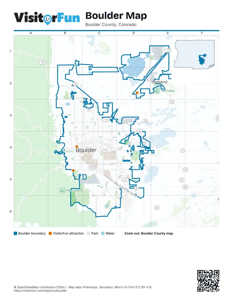
Street index of Boulder
Each street on the sheet and the grid squares it crosses.
- Denver–Boulder TurnpikeC5, D5
- Arapahoe AvenueB4, C4, D4
- Foothills ParkwayC3, D3, C4, D4, D5
- BroadwayB2, B3, B4, C4, C5
- Baseline RoadB5, C5, D5
- 28th StreetC3, C4, C5
- Canyon BoulevardB4, C4
- South BroadwayC5, C6, D6
- Table Mesa DriveC5, D5, C6
- Iris AvenueB3, C3
- Diagonal HighwayE1, C3
- South Boulder RoadD5
- IBM DriveE1
- 27th WayC5
- Boulder Canyon DriveB4
- Arapahoe RoadD4, E4
- Mineral RoadE1
- North Foothills HighwayB2
- South Foothills HighwayD6
- Pearl StreetB4, C4, D4
- 30th StreetC3, C4, C5
- 55th StreetD1, D4, D5
- 63rd StreetD1, D2, D4
- Colorado AvenueC4, D4
- Walnut StreetB4, C4, D4
- 15th StreetB2, B3, B4, C4, C5
- Mapleton AvenueB4, C4
- Folsom StreetC3, C4
- Valmont RoadC4, D4
- Lookout RoadD2, E2
- Spruce StreetB4, C4
- Greenbriar BoulevardC6
- Pearl ParkwayC4, D4
- Lehigh StreetC6
- Lee Hill DriveB2
- North 71st StreetE1, E2
- North 63rd StreetD1
- Jay RoadC3
- North 75th StreetE2
- Lee Hill RoadB2
- 19th StreetC2, C3, C4, C5
- 9th StreetB2, B3, B4, B5
- 13th StreetB2, B3, B4, B5
- 6th StreetB2, B3, B4, B5
- 17th StreetB2, B3, B4, C4, C5
- Spine RoadD2, E2, C5
- Kalmia AvenueB3, C3
- Aurora AvenueB5, C5, D5
- 47th StreetC3, C4
- 11th StreetB3, B4, B5
- Pine StreetB4, C4
- 26th StreetC3, C4
- 20th StreetC3, C4, C5
- 29th StreetC3, C4, C5
- Moorhead AvenueC5, D5
- Marine StreetB4, C4
- Mohawk DriveD5
- Alpine AvenueB4, C4
- NCAR RoadB5, C5, B6
- Pennsylvania AvenueB4, C4, D4
- 33rd StreetC4, C5
- University AvenueB4, C4
- Monarch RoadD1, E1
- Central AvenueD4
- College AvenueB4, C4
- Airport RoadD3, D4
- 28th Street Frontage RoadC4, C5
- Glenwood DriveC3
- Violet AvenueB2, C2
- Apache RoadC5, D5
- Independence RoadC3, D3
- Balsam AvenueB4, C4
- 38th StreetC4, C5
- Thunderbird DriveD5
- Sioux DriveD5
- Pawnee DriveD5
- Yarmouth AvenueB2, C2
- Regent DriveC4, C5
- Edgewood DriveC4
- Flatiron ParkwayD4
- South Cherryvale RoadD5, D6
- Cherryvale RoadD4
- Palo ParkwayC3
- Sunshine Canyon DriveB4
- Twin Lakes RoadE2
- Flagstaff RoadB5
- Williams Fork TrailE2
- Culver CourtC4
- Butte Mill RoadD4
- Ibm PlantE1
- 18th StreetB2, B3, B4, C4, C5
- 14th StreetB2, B3, B4, B5
- 10th StreetB2, B3, B4, B5
- 16th StreetB2, B3, B4, C4, C5
- 4th StreetB2, B3, B4
- 5th StreetB2, B3, B4, B5
- 7th StreetB2, B3, B4, B5
- 8th StreetB2, B3, B4, B5
- 23rd StreetC2, C3, C4
- Gillaspie DriveC5, C6
- Inca ParkwayC5, D5
- 22nd StreetC2, C3, C4, C5
- Linden AvenueB3, C3
- Ithaca DriveC5, C6
- Hawthorn AvenueB3, C3
- 21st StreetC3, C4, C5
- Avocado RoadB2, C2
- Cascade AvenueB5, C5, D5
- 34th StreetC3, C4, C5
- Grape AvenueB3, C3
- Martin DriveC5
- Euclid AvenueB4, C4
- Norwood AvenueB3, C3
- Dartmouth AvenueC5
- Darley AvenueC5, C6
- Manhattan DriveD5
- Bluff StreetB4, C4
- South Lashley LaneC5, C6
- Hartford DriveC5, C6
- Poplar AvenueB3, C3
- Longhorn RoadB1, C1
- Pleasant StreetB4, C4
- Caddo ParkwayC5, D5
- Cedar AvenueB4, C4
- Forest AvenueB3, C3
- Bear Mountain DriveC6
- Juniper AvenueB3, C3
- Kings Ridge BoulevardC3, D3, D4
- Winchester CircleE1, E2
- Lincoln PlaceB4, B5
- North StreetB4
- Bluebell AvenueB5, C5
- Upland AvenueB3, C3
- Kohler DriveC5
- Discovery DriveC4
- Columbine AvenueB5, C5
- Wonderland Hill AvenueB3
- Dellwood AvenueB4
- 12th StreetB4, B5
- Mariposa AvenueB5, C5
- Kittredge Loop DriveC5
- Quince AvenueB3, C3
- 3rd StreetB2, B3, B4
- 32nd StreetC4, C5
- Dakota BoulevardB2
- Sumac AvenueB3, C3
- Evergreen AvenueB3, C3
- Harrison AvenueD4
- Grandview AvenueB4, C4
- Vail CircleD3
- Toedtli DriveC5, C6
- Eisenhower DriveD4
- Vassar DriveC5
- Briarwood DriveC6
- Gapter RoadD4, D5
- Grove StreetB4, C4
- Gunpark DriveE2
- Redwood AvenueB3, C3
- Airport BoulevardD3
- Maxwell AvenueB4
- South 42nd StreetC5
- Franklin DriveC3, D3, C4
- Yale RoadC5, C6
- Meadow AvenueB3, C3
- Longbow DriveD2
- Tamarack AvenueB3, C3
- Blueberry CircleC2
- Stanford AvenueC5
- Left Hand CircleE2
- North 55th StreetD1
- Compton RoadC5
- Gunbarrel AvenueD2
- Seminole DriveD5
- Judson DriveC6
- Emerson AvenueC6
- Orchard AvenueB3, C3
- 24th StreetC3, C4
- Utica AvenueB3
- Laurel AvenueD5
- Pearl East CircleC4, D4
- Maxwell AlleyB4
- Greenbriar CourtC6
- McKinley DriveD4
- South 38th StreetC5
- Junction PlaceC4
- Cloverleaf DriveB3, C3
- 31st StreetC4, C5
- Juilliard StreetC6
- Sleepytime DriveD2
- 35th StreetC4, C5
- Elder AvenueB3, C3
- Oak AvenueB3, C3
- Grant PlaceB4, B5
- Zamia AvenueB2
- South 41st StreetC5
- Laramie BoulevardB2
- 27th StreetC4, C5
- Heidelberg DriveC6
- Stazio DriveD4
- Curie CircleC5
- Gallatin PlaceD4
- Holmes PlaceD4
- South 40th StreetC5
- Sterling DriveD3, C4, D4
- Skunk Canyon Service RoadB5, C5
- Ludlow StreetC6, D6
- Augusta DriveE2
- MacAllister RoadC4
- Brooklawn DriveD5
- Chippewa DriveC5, D5
- Ash AvenueC5
- Berea DriveC6
- Balsam DriveC4
- Harvard LaneC5
- King AvenueB5, C5
- 15th AlleyC4, C5
- Tom's WayB4
- Lawry LaneB4
- Gilpin DriveC5
- Merritt DriveD4
- South 43rd StreetC5
- 48th StreetD4
- Meadow Glen DriveD4, D5
- Doral DriveE2
- Eagle WayC3
- South 46th StreetC5, C6
- Lafayette DriveC6
- Wildwood RoadC6
- Tantra DriveD5
- South 35th StreetC5
- West Moorhead CircleD5, D6
- Hanover AvenueC5
- Iroquois DriveD5
- Xanthippe Rd.D5
- Cypress DriveD5
- Endicott DriveC6
- Longwood AvenueC6
- Osage DriveD5
- South 44th StreetC5
- Bradley DriveD6
- Crescent DriveD4, D5
- Iliff StreetC6
- South 36th StreetC5
- McGuckin WayC4
- Bellevue DriveB5
- Wilderness PlaceC4
- Yellow Pine AvenueB2
- 36th StreetC4, C5
- Waite DriveD4, D5
- Dover DriveC5
- Pine AlleyB4
- Floral DriveC3
- Chambers DriveC6, D6
- Morgan DriveD4, D5
- 37th StreetC4, C5
- Nautilus DriveD2, E2
- Union AvenueB3
- Dewey AvenueB4
- South 45th StreetC5
- University AlleyB4
- Lipan WayC5, D5
- Madison AvenueC4
- Lodge LaneD4
- Pierre StreetB2
- University Heights AvenueC4
- 25th StreetC3, C4
- Edinboro DriveC6
- Baseline Frontage RoadC5
- Mapleton AlleyB4
- Sunset BoulevardB4, C4
- Riverside AvenueB3, C3
- Albion WayC6
- Meredith WayD4
- Sycamore AvenueD4, D5
- Patton DriveD4
- Laguna PlaceD5
- Cinnamon CircleC2
- Concord AvenueB4
- High StreetB4
- Roxwood LaneD4, D5
- Scrub Oak CircleC6
- Evans DriveC5
- North Orchard Creek CircleD2
- Persimmon DriveB2
- Stadium DriveC4
- Hopi PlaceC5
- South 39th StreetC5
- Aztec DriveD5
- South Hampton CircleC3
- Kenwood DriveC5
- Sentinel DriveC3, D3
- Highland AlleyB4
- Paonia StreetC3
- Saint John's AvenueC3
- Erie DriveC5
- Racquet LaneD5
- Nautilus Court SouthE2
- Illini WayD5
- Concord AlleyB4
- Qualla DriveD5
Things to do on the Boulder map
Places on the map
- Admiral Arleigh A. Burke Park
- Alcove on Arapahoe
- Arapahoe Ridge Park
- Basemar Center
- Bear Creek Elementary School
- Boulder High School
- Boulder Municipal Airport
- Boulder Public Library, Meadows Branch
- Boulder Reservoir
- Carlson Gymnasium
- Casey Middle School
- Centennial Middle School
- Chautauqua Park
- Columbia Cemetery
- Columbine School
- Community Park Trail
- Coot Lake
- Crossroad Commons
- Dal Ward Athletic Center
- East Boulder Community Park
- Extra Space Storage
- Flatirons Golf Course
- Foothills Community Park
- Foothills Hospital
- Gunbarrel Tech Center
- Harlow Platts Community Park
- Long's Gardens
- Meadows on the Parkway
- Mesa Reservoir
- Naropa University
- National Center for Atmospheric Research
- Tantra Park
- Twenty Ninth Street
- University of Colorado Boulder (Main Campus)
- Valmont Bike Park
- Valmont City Park
- Valmont Disc Golf Course
- Viele Lake
- Williams Village
- Wonderland Lake
Next to Boulder
- Gunbarrel
© OpenStreetMap contributors, Open Database License, openstreetmap.org/copyright · Map data: Protomaps · Boundary: Who's On First (CC-BY 4.0); Quattroshapes (CC BY 2.0)