

Colorado map
Louisville map
About 20,811 people live here (Census Bureau, 2024 estimate). The sheet's index lists 300 streets; West Dillon Road, West South Boulder Road and South McCaslin Boulevard cross the most grid squares. Things to do inside the boundary: Zinn Cycles.
Open the map (PDF, US Letter)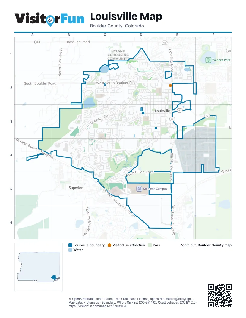
Street index of Louisville
Each street on the sheet and the grid squares it crosses.
- Denver–Boulder TurnpikeD6
- West Dillon RoadB4, C4, C5, D5, E5, F5
- West South Boulder RoadB2, C2, D2, E2
- South McCaslin BoulevardB3, C3, B4, C4
- Courtesy RoadE1, E2, E3
- East South Boulder RoadD2, E2
- South 96th StreetE3, E4, E5
- South Boulder RoadB2
- 96th StreetE5
- Dillon RoadE5
- Via Appia WayD2, B3, C3, D3
- McCaslin BoulevardB2, B3
- Marshall DriveA4
- Empire RoadF3
- West Cherry StreetC4, D4
- Centennial ParkwayB3, B4, C4
- Washington AvenueC2, B3, C3
- Century DriveB3, B4, C4
- South 104th StreetF3, F4, F5
- West Dahlia StreetC3, C4
- West Pine StreetC3, D3
- South 88th StreetD5
- Tyler AvenueC2, C3
- North Hoover AvenueD3
- Bella Vista DriveD3, E3, D4
- Pine StreetD3, E3
- County RoadE3, E4
- Centennial DriveD1, D2
- Empire DriveE3, F3
- Front StreetE2, E3
- Campus DriveD5, E5
- Century PlaceB4
- West Centennial DriveD1, D2
- South Hoover AvenueD3, D4
- South Polk AvenueC3
- Saint Andrews LaneD4, C5, D5
- CTC BoulevardF3, F4, F5
- Main StreetE2, E3
- Jefferson AvenueD2, D3
- Garfield AvenueD1, D2, D3
- Health Park DriveC5, D5
- West Willow StreetB2, C2
- Hecla DriveE1, E2
- Fairfield LaneC4, D4
- Cherry StreetE4, F4
- South Taylor AvenueE3, E4
- South Pierce AvenueE4, E5
- West Mulberry StreetC3, C4
- Eisenhower DriveC2, D2
- Owl DriveC3
- West Linden StreetC2
- Lincoln AvenueD2, D3
- South Arthur AvenueE4
- Griffith StreetD2, E2
- Sorrel AvenueE5, E6
- Walnut StreetD3, E3
- Grant AvenueD2, D3
- South Madison AvenueC3, C4
- Dogwood StreetF4
- Kennedy AvenueC2
- Taylor AvenueE3, F3
- La Farge AvenueD2, D3
- Boxelder StreetE4, F4
- Spruce StreetD3, E3
- East Lafayette StreetD2, E2
- West Enclave CircleB3
- Trail Ridge DriveC3
- Manorwood LaneC4, D4
- Arapahoe CircleB3, C3
- Infinite DriveB4
- Caledonia StreetD2, E2
- Short StreetD2, E2
- Dyer RoadB4
- Cherrywood LaneC3, C4
- Coal Creek CircleC4, C5
- Club CircleC4
- Lois DriveD3, E3
- South StreetD3, E3
- Rockcress DriveE6
- Franklin AvenueD1, D2
- Ridge View DriveC4
- West Alder StreetB2, C2
- East StreetE3
- Harper StreetD2, E2
- Pheasant RunD2
- West Elm StreetD3
- Orchard DriveC4
- Snowberry LaneE1
- Cannon StreetE2, E3
- Regal StreetD2
- Roosevelt AvenueE3
- West Tamarisk StreetC2
- East West StreetD3, E3
- Dogwood CircleD1
- West Spruce StreetD3
- South Jefferson AvenueD4
- Wagon WayD1, E1
- Nighthawk CircleC3
- West Sycamore LaneD3
- Eldorado LaneB3, C3
- Augusta DriveD4
- Mc Kinley AvenueD2, D3
- Prairie WayF3
- West Arrowhead StreetC2, D2
- Sunland StreetD1
- Arthur AvenueE4
- Evans AvenueD1
- West Lafayette StreetD2
- Orchard WayC4
- South 80th StreetB2
- Ridgeview DriveC2
- Jackson CircleD2
- Plaza DriveE2
- Via CapriD2
- South Lark AvenueC4
- Century CircleB4, C4
- Summit View DriveE1
- Blue Star LaneE1, E2
- Spyglass CircleC5, D5
- Spruce CircleC3
- South Cleveland AvenueC3, D3, C4
- Continental View DriveB2, C2
- Steel StreetD2, E2
- West Sagebrush DriveC2
- Hutchinson StreetD3, E3
- Coal Creek LaneC4, D4
- Via RomaD2
- South Washington AvenueC3, C4
- West Chestnut CircleC4
- Caledonia CircleD2
- Hillside LaneB3
- Harper Lake DriveC2, C3
- Monarch StreetD1
- West Choke Cherry DriveB2, C2
- West Plum CircleC2
- Wildrose WayC3
- Lakespur LaneE1, E2
- Park LaneE1
- West Spruce LaneD3
- Tech CourtF4, F5
- Adams AvenueD2, D3
- Treece StreetD1, E1
- Golden Eagle WayE1
- Turnberry CircleC5
- Vista LaneC3
- Cleveland AvenueD3
- Sunset DriveD2
- Hecla WayE2
- South Front StreetE3
- South Buchanan AvenueC3, C4
- McKinley Park LaneD2
- West Spruce WayC3, D3
- Ridge PlaceC4
- Fireside StreetD2
- West Sycamore CircleC3, D3
- McKinley AvenueD1
- Sunflower StreetB3, C3
- Hays DriveC2
- West Hackberry StreetC3, D3
- Sunnyside StreetD2
- Muirfield CircleC5
- West Mahogany CircleC4
- South Fillmore AvenueC3
- Short PlaceD2
- Sweet Clover LaneE2
- West Ash StreetC2
- Lincoln CircleD3
- West Aspen WayC4
- Aspen WayD3, D4, E4
- Catalpa CourtD3
- Dahlia DriveD4
- Pinehurst CourtC4, D4
- South Buchanan CircleC4
- Fillmore CourtC2, C3
- Cliffrose LaneD1
- South Tyler AvenueC3
- South Adams DriveD4
- Luke StreetD2, E2
- South Taft CourtC4
- Lilac CircleD4
- Rex StreetE3
- Cottonwood DriveD2
- South Roosevelt AvenueE3, E4
- West Hawthorn StreetC2
- Willow PlaceB3
- Dahlia WayD4
- Copper Hill CourtB2, C2
- Johnson StreetD3, E3
- Kaylix AvenueE1
- Wynonna CourtD1
- Walnut LaneD3
- Augusta LaneD4
- Chestnut StreetD4
- East Raintree CourtD3
- Parkview StreetE3
- West Harper StreetD2
- West Willow CourtC2
- West Sandbar CircleC3
- West Hickory StreetC2
- Elm StreetE3
- Paradise LaneE5
- West Sagebrush CourtC2
- South Aline StreetD3
- Grove DriveC3
- West Barberry CircleC2
- Juniper StreetD4
- Senator DriveD1
- Azure WayC2
- Lee AvenueE3
- Larkspur LaneB3, C3
- Ponderosa CourtC3
- Fillmore PlaceC2
- Church LaneC3
- Lois CircleD3
- West Hemlock CircleC3
- Quail CircleD2
- Longs Peak DriveD2
- Manorwood CourtC4, D4
- Jackson DriveD1
- Cleveland CourtD3
- Innovation StreetE4
- West Cedar WayD2
- West Maple CourtC2
- Barbara StreetD3
- Grove CourtC2, C3
- West Tyler AvenueC2
- Regal CourtD2
- Sagebrush WayD2, D3
- White Violet WayE2
- Welsh CourtC3, D3
- West Birch CourtC2
- Taft PlaceC2
- West Cactus CourtD2, C3, D3
- West Chestnut CourtC4
- West Juniper CourtC4
- Madison CourtC2
- Cinnamon LaneC3
- Cypress LaneC3
- Circle DriveD2
- Lincoln CourtD3
- Bluestem LaneD1, E1
- Meadowlark LaneD1, E1
- Tamarisk CourtC2
- West Enclave WayB3
- West Fir CourtC3
- Apple CourtC4
- Hoptree CourtD3
- Monroe PlaceD2
- Buckthorn WayC3, D3
- Meadow CourtC3
- Pine Needle LaneC3
- Copper LaneC4
- Peach CourtC4
- North Franklin CourtD2
- Majestic View DriveB2
- Honeysuckle LaneB3, C3
- Van Buren CourtD3
- Ford PlaceC2
- Troon CourtC5
- West Lois WayC3, D3
- Lock StreetE3
- West Cedar PlaceC2
- West Sycamore CourtD3
- Rose StreetD3
- Mc Kinley PlaceD2
- Springs CoveD4
- West Griffith StreetD2
- Wilson PlaceD2
- South Lincoln AvenueD4
- West Lois CourtC3
- Columbine CourtC3
- South Carter LaneD4
- Vulcan StreetD1
- Magpie LaneE1
- West Fir WayC3, D3
- West Sycamore StreetC3
- West Sumac CourtD3
- Johnson LaneE2
- Maria LaneE2
- Grouse CourtC3
- Lafayette StreetE2
- Leonard LaneE2
- Night Hawk CircleC3
- Jules LaneD2, E2
- Owl CourtC3
- Estes WayC3
- Monarch CourtD1
- Eagle CourtC2, C3
- Matchless StreetD2
- Osprey CourtC3
- West Oak CourtC2
- Diamond CircleD4
- South Carter CourtD3, D4
- Mead StreetD3, E3
- Buchanan CourtC3
- Mesa Point PlaceC2
- South Carter AvenueD4
- Jackson CourtD2
- Coventry LaneC4
- Gallagher LaneE2
Things to do on the Louisville map
Places on the map
- Admor Open Space
- AdventHealth Avista Hospital
- Annette Brand Park
- Aquarius Open Space
- Ascent Community Church
- Boulder Innovation Campus
- Bullhead Gulch Open Space
- Centennial Center
- Centennial Gateway
- Centennial Marketplace
- Centennial Valley Business Park
- Christopher Plaza
- Cleo Mudrock Park
- Coal Creek Golf Course
- Coal Creek Ranch Park
- Colony Square
- Cottonwood Park
- Coyote Run Open Space
- CTC Open Space
- Damyanovich Open Space
- Daughenbaugh Open Space
- Davidson Mesa
- Dutch Creek Open Space
- Fireside Elementary School
- Harper Lake
- Hecla Lake
- Hecla Lake Open Space
- Heritage Park
- Hillside Open Space
- Lake Park
- Leon Wurl Trail
- Leon Wurl Wildlife Sanctuary
- Louisville Community Park
- Louisville Reservoir Number 1
- Louisville Sports Complex
- Monarch Campus
- North Open Space
- Recreation Center Campus
- Walnut Open Space
- Warembourg Open Space
Next to Louisville
- Nyland Cohousing Community
- Superior map
© OpenStreetMap contributors, Open Database License, openstreetmap.org/copyright · Map data: Protomaps · Boundary: Who's On First (CC-BY 4.0); Quattroshapes (CC BY 2.0)















