

Connecticut map
New London map
About 28,081 people live here (Census Bureau, 2024 estimate). The sheet's index lists 300 streets; Ocean Avenue, Williams Street and Jefferson Avenue cross the most grid squares. Things to do inside the boundary: Connecticut College Arboretum, Custom House Maritime Museum and Lyman Allyn Art Museum.
Open the map (PDF, US Letter)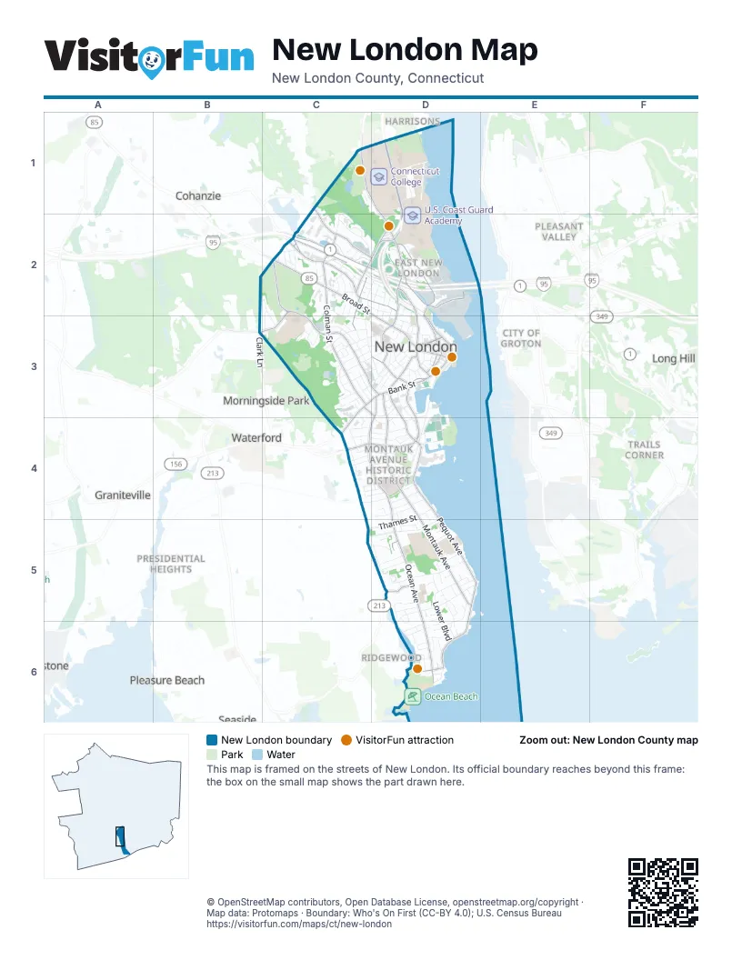
Street index of New London
Each street on the sheet and the grid squares it crosses.
- Jefferson AvenueC2, C3, D3
- Colman StreetC2, C3
- Broad StreetC2, D3
- Mohegan AvenueD1, D2
- Bank StreetC3, D3, C4
- North Frontage RoadC2, D2
- Huntington StreetD2, D3
- South Frontage RoadC2
- Eugene O'Neill DriveD2, D3
- Water StreetD2, D3
- Governor Winthrop BoulevardD3
- State StreetD3
- Truman StreetD3
- Jay StreetD3
- Ocean AvenueD3, C4, D4, D5, D6
- Williams StreetC1, D1, D2, D3
- Crystal AvenueD2
- State Pier RoadD2
- Willetts AvenueC4, D4
- Briggs StreetC2, D2
- Howard StreetD3, D4
- Chester StreetC2, B3, C3
- Niles Hill RoadD5
- Green StreetD3
- Briggs Mohegan ConnectorD2
- Lee AvenueC3, D3
- Tilley StreetD3
- Clark LaneB3
- Pequot AvenueD4, D5, D6
- Montauk AvenueD3, D4, D5
- Vauxhall StreetC2, D2
- Bayonet StreetC1, C2, D2
- Shaw StreetD3, D4
- Ledyard StreetC2, C3
- Blackhall StreetD3
- Blinman StreetD3
- Neptune AvenueD6
- Old Norwich RoadC1
- Fog Plain RoadB3
- Thames StreetD4, C5, D5
- Glenwood AvenueD5, D6
- Connecticut AvenueC2, C3, D3
- Gardner AvenueD5
- Lower BoulevardD5, D6
- Hempstead StreetD2, D3
- Elm StreetC3, D3
- Lincoln AvenueC3, D3
- Shaw's CoveD3, D4
- Norwood AvenueC2, D2
- Hawthorne DriveC2
- Farmington AvenueC5, D5
- Ashcraft RoadC3
- Garfield AvenueC3, D3
- Plant StreetD5
- Harriet LaneD1, D2
- Admiral DriveD5, D6
- Lake loopC1
- Viets StreetC4
- Cedar Grove AvenueC2, C3
- Cove View RoadD5
- Squire StreetC4, D4
- Goshen StreetD3, D4
- Bear DriveD1, D2
- Parkway SouthD5, D6
- Nautilus DriveC5, D5
- TampaD2
- East StreetD3, D4
- Laurel DriveC3
- Riverview AvenueD4
- Michael RoadC2, C3
- Raymond StreetC2
- Faire Harbour PlaceD4
- School StreetD4
- Oneco AvenueD1
- Hawthorne Drive NorthC2
- Union StreetD3
- Adelaide StreetD2
- Aitchison DriveD5
- Alger PlaceC4, D4
- Blydenburg AvenueC4, D4
- Summer StreetC3
- De Biasi DriveD5
- Bellevue PlaceD4
- Mansfield RoadD5
- Reservoir StreetD1
- Westridge RoadD5
- Redden AvenueC3
- Bayshore DriveD6
- Rosemary StreetD2
- West Coit StreetD3
- Winchester RoadD1
- West StreetC2, D2
- Boulder DriveC3
- South Water StreetD3
- Washington StreetD3
- Harris Drive ExtensionC1, D1
- Walbach StreetD4
- Phillips StreetC2
- Beckwith StreetC4
- Walden AvenueC3
- Waller StreetC3, D3
- Ferry StreetD3
- Cole StreetD2
- Highland AvenueD6
- Mountain AvenueD3
- Crest StreetD2
- Federal StreetD3
- Longview StreetC4
- Lewis StreetD2
- Crescent StreetD4
- Granite StreetD3
- Chapel WayC1, D1
- Morgan StreetC2
- Woodlawn RoadD6
- Brainard StreetD3
- Sherman StreetD4
- Sunset StreetC4
- Hamilton StreetD3, D4
- Cutler StreetC3
- Mott AvenueD6
- Dell AvenueC4, D4
- Maple AvenueD4
- Anthony RoadC2, C3
- Belden StreetD3
- Nob Hill RoadD5
- Ledge RoadC3
- Denison AvenueD4
- Fitch AvenueC2, D2
- Third AvenueC2
- Mercer StreetD3
- Grove StreetD2
- Ridgeview CircleC2
- Gorton StreetC4
- Warren StreetC3
- Glenwood PlaceD5, D6
- Greenway RoadD6
- Pacific StreetD4
- Lester StreetD5
- Park StreetD6
- Georgiana StreetC2, C3
- Terrace AvenueD2
- Evergreen AvenueD4
- Franklin StreetD3
- CampbellD2
- Gallows LaneC1
- West High StreetC3
- Shirley LaneD6
- Trumbull StreetD4
- Chapel DriveD5
- Nameaug AvenueD1
- Westomere TerraceD5
- Atlantic RoadD3
- Coit StreetD3
- Berkeley AvenueD2
- Sander StreetC4, D4
- Deshon StreetD1
- Linden StreetC4, D4
- Henry StreetC4, D4
- Granada TerraceD5
- Stuart AvenueD6
- Hall AvenueD5
- Prest StreetD3
- Meridian StreetD3
- Addison StreetC2, D2
- Pleasant StreetC3
- Dow StreetC2, C3
- Channing StreetD2, D3
- Perry StreetD4
- Hillside RoadD6
- Learned StreetC2
- Buchanan DriveC3
- Harris RoadD4
- Katie LaneD5
- Reyquinn StreetD5
- Dart StreetD5
- Fuller StreetC3
- Orchard StreetD4
- Westwood AvenueC3
- Golden StreetD3
- River Ridge RoadD1
- Central AvenueD2
- Converse PlaceD4
- Fifth AvenueC2
- Nameaug StreetD4
- Chappell StreetC3, D3
- Moore AvenueD3, D4
- Eastern AvenueD2
- Farnsworth StreetD1
- Jerome RoadD6
- Rogers StreetC3
- Bristol StreetD2, D3
- Robinson StreetD4
- Summit AvenueD2
- Center StreetD2, D3
- Reed StreetD3
- Ann StreetD4
- Hunter Liggett DriveD1
- Grand StreetD3
- Manwaring StreetD3
- Maxson PlaceD5
- Lodus CourtD5
- Riverside Heights RoadD2
- Fourth StreetD2
- Seneca DriveD2
- Parkway NorthD5
- Steward StreetD3
- Stanners StreetD2
- Avery CourtD4
- Mahan StreetC4
- Konomoc StreetC2
- Spring StreetC3, D3
- Chelsea StreetD4
- Cottage StreetD3
- Bulkeley PlaceD3
- Sunset RoadC1
- Eldane StreetD6
- Crocker StreetD5
- Fourth AvenueC2
- Willow LaneD4, D5
- Gardner CircleD5
- Thomas Griffin RoadD2, D3
- Terrace BoulevardC2
- Carroll CourtC3, C4
- South Ledyard StreetC3
- Darrow StreetD3
- Home StreetD3
- Gordon CourtD2
- Perkins StreetC2
- Guthrie PlaceD6
- McDonald StreetC3, D3
- Elrin PlaceD6
- Worthington RoadD6
- Mallove DriveD5
- West Pleasant StreetC3
- Acorn CourtC2
- Fowler CourtC4, D4
- Jennie StreetC2
- Keeney LaneD5
- Mary StreetC2
- Washburn RoadD5, D6
- Belvidere StreetC2
- Cape Ann CourtC3
- Easy StreetD5
- Nathan Hale StreetD2
- Pearl StreetD3
- Waller CourtC3, D3
- Garvin StreetD3
- Recreation WayD4
- Harbor View AvenueC2
- Brewer StreetD3
- Neptune CourtD6
- Smith StreetD4
- Colver StreetC3
- Wall StreetC3
- Charles StreetC4
- Quinnepeag AvenueD5
- Catherine StreetD4
- Sixth AvenueC2
- Garfield Avenue ExtensionC3
- Starr StreetD3
- Morton StreetD5
- Georgetown RoadD5
- Alger StreetD4
- Cleveland StreetD2, D3
- Margaret StreetC2
- Sharaf StreetD4, D5
- Bolles AvenueD2
- Bowditch StreetD4
- First AvenueC2
- Holly TerraceD5
- Wightman StreetD4
- Amity StreetD3
- Eastridge RoadD5
- West Guthrie PlaceD6
- Bailey CircleD2
- Bragaw StreetD2
- Hope StreetD3
- Parker StreetC2
- Masonic StreetD3
- Moran StreetC4
- Elliott AvenueD6
- Henderson RoadD6
- Braemer PlaceC3
- Fern StreetC3
- Whittlesey StreetC2
- Penny LaneD5
- Walker StreetD2
- Winthrop StreetD2
- Buell PlaceD3
- Marshall PlaceC3
- Mill StreetD2
- Prospect StreetD3
- Harbor LaneD5
- Waldo StreetC2
- Billard RoadD5
- North Ridge RoadC1, D1
- Hislop StreetC2
- Tinker CourtD3
- Cedar Grove Avenue ExtensionC2
- Belden CourtD3
Things to do on the New London map
Places on the map
- Amistad Landing
- Bates Woods Park
- Burr's Marina
- Caulkins Park
- Cedar Grove Cemetery
- Chapel Green
- Colonial Hyundai of New London
- Connecticut College
- Connecticut College Pond
- Crocker's Boat Yard
- Crocker's Boatyard
- Dye House Pond
- Ferry Slip
- Ferry Slip Dockominiums
- Fort Trumbull State Park
- Girard Toyota
- Lawrence+Memorial Hospital
- Meeting House Hill
- Mercedes-Benz of New London
- Mercer Field
- Nathan Hale Arts Magnet School
- Nelson W. Nitchman Fields
- Neptune Park Association Beach
- New London Armory
- New London High School Multi-Magnet Campus
- New London Mall
- New London Post Office
- New London Shopping Center
- Ocean Beach
- Ocean Beach Park
- Osprey Beach
- Prospect Hill
- Riverside Park
- Robert Crown Park
- Saint Mary's Cemetery
- Secor Subaru
- Secor Volvo
- Silfen Track
- U.S. Coast Guard Academy
Next to New London
- City of Groton
- Cohanzie
- Governor's Landing
- Graniteville
- Graniteville Historic District
- Groton Bank Historic District
- Harrisons
- Hartford Colony Historic District
- Jordan Village
- Jordan Village Historic District
- Long Hill
- Manitock Spring
- Millstone
- Morningside Park
- Pleasant Valley
- Pleasure Beach
- Presidential Heights
- Ridgewood
- Seaside
- Trails Corner
- Waterford
© OpenStreetMap contributors, Open Database License, openstreetmap.org/copyright · Map data: Protomaps · Boundary: Who's On First (CC-BY 4.0); U.S. Census Bureau















