

Florida map
Clearwater map
About 116,811 people live here (Census Bureau, 2024 estimate). The sheet's index lists 300 streets; Gulf to Bay Boulevard, Sunset Point Road and Drew Street cross the most grid squares. Things to do inside the boundary: Clearwater Beach, Clearwater Marine Aquarium and Countryside Mall.
Open the map (PDF, US Letter)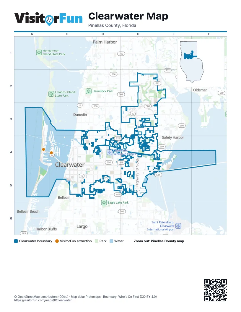
Street index of Clearwater
Each street on the sheet and the grid squares it crosses.
- US Highway 19 NorthD3, D4, D5
- Dillinger McCabe Bayside BridgeE4, E5
- US 19 NorthD3
- US Highway 19 SouthD3
- Gulf to Bay BoulevardC4, C5, D5, E5
- Courtney Campbell CausewayE4, F4, E5
- McMullen Booth RoadE2, E3, E4
- US 19 Northbound Frontage RoadD3, D4, D5
- US 19 Southbound Frontage RoadD3, D4, D5
- South Missouri AvenueB4, B5
- Memorial CausewayA4, B4, B5
- State Road 580E2, D3, E3
- Gulf BoulevardA4, A5
- Court StreetB4, B5, C5
- South Gulfview BoulevardA4, B4
- Southbound Frontage RoadD4, D5
- Northbound Frontage RoadD4, D5
- Coronado DriveA4
- Chestnut StreetB5
- Hamden DriveA4
- Causeway BoulevardA4
- Clearwater Beach RoundaboutA4
- Sunset Point RoadB4, C4, D4, E4
- Drew StreetB4, C4, D4, E4
- Countryside BoulevardD2, D3
- North Belcher RoadD3, D4
- South Keene RoadC4, C5
- North Keene RoadC3, C4
- Lakeview RoadB5, C5, D5
- Belleair RoadB5, C5, D5
- Northeast Coachman RoadC4, D4
- South Belcher RoadD4, D5
- North Fort Harrison AvenueB4
- South Myrtle AvenueB4, B5
- Douglas AvenueB3, B4
- South Ft Harrison AvenueB4, B5
- Fairmont StreetB4, C4
- North Myrtle AvenueB4
- Marshall StreetB4
- North Missouri AvenueB4
- Edgewater DriveB3, B4
- Keene RoadC3
- Fulton AvenueB4
- Belcher RoadD5
- Clearwater Largo Road NorthB5
- 10th Street SouthE4
- Cleveland StreetB4, C4, D4, E4
- Landmark DriveD2, D3
- Druid RoadB5, C5, D5
- Island WayB3, B4
- Palmetto StreetB4, C4, D4
- Jeffords StreetB5, C5
- Nursery RoadC5, D5
- North Hercules AvenueC3, C4
- Union StreetB3, C3, D3
- North Highland AvenueC3, C4
- Mandalay AvenueA3, A4
- North Betty LaneC3, B4, C4
- Harn BoulevardD5
- South Martin Luther King Junior AvenueB4, B5
- South Highland AvenueC4, C5
- North Martin Luther King Junior AvenueB4
- Enterprise Road EastD3, E3
- South Hercules AvenueC4, C5
- Kings HighwayC3, C4
- North Old Coachman RoadD3, D4
- North Bayshore BoulevardE4
- Eldorado AvenueA3, A4
- Seminole StreetB4, C4
- South Lake DriveC4, C5
- North Saturn AvenueC4
- Montclair RoadC3, C4
- Belleview BoulevardB5, C5
- Overbrook AvenueB4, C4
- Enterprise RoadD3
- Druid Road EastD5
- Northside DriveD2
- Soule RoadD3, D4
- Eastland BoulevardD3, E3
- North Hampton RoadD4
- Bayway BoulevardA4, B4
- South Bayview AvenueD4, D5
- South Old Coachman RoadD4, D5
- Access Road AD4
- Druid Road SouthB5
- Village DriveD3
- South Fort Harrison AvenueB5
- South Bayshore BoulevardE4, E5
- South Lake AvenueC5
- North Bayview AvenueD4
- South Hampton RoadD4, D5
- Druid Road WestB5
- Imperial WayC5
- Gateway DriveC5
- Hercules AvenueC5
- Greenbriar BoulevardD3
- Ponce de Leon BoulevardC5
- Hampton RoadD4
- Old Coachman RoadD4
- Magnolia DriveB5, C5
- Turner StreetB5, C5
- South Hillcrest AvenueC4, C5
- South Betty LaneB4, C4, B5, C5
- Bay EsplanadeA3, A4
- South Evergreen AvenueC4, C5
- Pierce StreetB4, C4
- Rainbow DriveC4
- Seville BoulevardD5
- Grove StreetB4, C4
- South Prospect AvenueB4, B5
- South Madison AvenueB4, B5
- North Osceola AvenueB4
- Rogers StreetB5, C5, D5
- Laura StreetB4, C4
- Lotus PathB5, C5
- South Duncan AvenueC4, C5
- Jasmine WayB5, C5
- Hyde Park DriveD2
- Ewing AvenueB4, B5
- North Garden AvenueB4
- South San Remo AvenueC4, C5
- Maple StreetB4, C4
- Franklin StreetB4, C4
- Wildwood DriveD3
- Eldridge StreetB4, C4
- Woodlawn StreetB5, C5
- Calumet StreetB4, C4, D4
- Meadow Wood DriveD2
- Masters DriveD2
- Winding Wood DriveD3
- Blanche B Littlejohn TrailB4
- Flagler DriveC4
- Stag Run BoulevardD4
- Pine StreetB5, C5
- Bruce AvenueA3, A4
- Howard StreetB5, C5
- Pennsylvania AvenueB4
- Sherwood StreetC4
- Park StreetB4, C4
- Fairwood AvenueD4
- Brentwood DriveC5, D5
- South Lincoln AvenueB4, B5
- Greenlea DriveC4
- Saint Croix DriveD4
- Engman StreetB4, C4
- Washington Avenue SouthB4, B5
- Pinellas StreetB5
- Bay AvenueB5
- Stewart BoulevardD5
- Regency Oaks BoulevardD3
- Murray AvenueC4
- McKinley StreetC4
- Laurelwood DriveD3
- Casler AvenueC4
- Brigadoon DriveD4
- Burnice DriveC5, D5
- Lantana AvenueA3, C3, A4
- North Washington AvenueB4
- North Glenwood AvenueC4
- South Park Place BoulevardD4, D5
- San Bernadino StreetE4
- Harbor IslandB3, B4
- Northridge DriveD2
- Windward PassageB4
- Palm Bluff StreetB4
- San Mateo StreetE4
- Sandy Ridge DriveD2
- San Jose StreetE4
- Frisco DriveD3
- Young AvenueB5
- Narcissus AvenueA3
- North Madison AvenueB4
- Midway IslandB4
- Summerlin DriveD5
- Saint John DriveD4
- Sunset DriveB4
- Seabreeze StreetC5
- Poinsettia AvenueA4
- Sandy LaneC4
- Long StreetC4
- Pinebrook DriveC4
- Jones StreetB4
- North Jefferson AvenueB4
- South Arcturas AvenueC4, C5
- Sharkey RoadD4
- Edenville AvenueD5
- San Pedro StreetE4
- Seton DriveC3, C4
- Via CiprianiD5
- South Michigan AvenueB5
- South Glenwood AvenueC4, C5
- Westchester Drive NorthD2
- Vine AvenueB4
- Algonquin DriveC3, C4
- South Prescott AvenueB5
- Souvenir DriveC3, C4
- Nash StreetD4
- Brookside DriveC5
- Linwood DriveC4
- Catherine DriveD4
- Ridgewood StreetC4
- Airport DriveC4
- Byram DriveC3, C4
- Nugget DriveC3, C4
- Windward Island RoadB4
- Richards AvenueC4
- Bayside DriveA4, B4
- Harbor DriveB4
- Alameda AvenueE4
- Overlea StreetC4
- Woodcrest AvenueC5
- South Keystone AvenueC5
- Williams DriveD5
- Sunnydale BoulevardC4, D4
- Springrains DriveC3
- Canterbury RoadC5
- La Salle StreetB4
- Harding StreetC4
- Ridge AvenueC4
- Lake Shore LaneD2
- Barry StreetC5
- Jackson RoadB4, C4
- McFarland DriveE4
- Brattle LaneD2
- Hamlet AvenueB5
- Scott StreetC4
- Bay Berry DriveD3
- Leeward IslandB4
- Shelley StreetD5
- Moore Haven Drive WestD3
- Willow Tree TrailD3
- Range RoadC4, D4
- Wildwood WayB5
- Tangerine StreetB4, C5
- Morningside DriveD4, D5
- Snug IslandB3, B4
- Flushing AvenueD5
- Saber DriveD3
- Wood AvenueC4
- Sedeeva StreetB3, B4
- Saint Charles DriveD5
- Nicholson StreetB4, C4
- Woodside AvenueC5
- Browning StreetC5
- North Park Place BoulevardD4
- Maximo AvenueE4
- Gentry StreetC4
- Grand Central StreetB5
- Mariva AvenueC4
- Moore Haven Drive EastD3
- North Duncan AvenueC4
- Sharondale DriveC4
- Lawson RoadD3, D4
- Gilbert StreetC4
- Bellemeade DriveC4
- South East AvenueB4, B5
- North Lincoln AvenueB4
- Lombardy DriveC4
- Glenmoor Road NorthD5
- Edenwood StreetD4
- Ridgeway DriveC4
- Whitman StreetD4
- Chaucer StreetD4, D5
- Quail Hollow Road EastD2, D3
- Greenhill DriveC4
- Chautauqua AvenueD3
- Fox Hill DriveD2
- BroadwayB3
- Parkwood StreetC4
- Springdale StreetC4
- Woodbine StreetC4
- North Jupiter AvenueC4
- Park Trail LaneD4
- North Mars AvenueC4
- Wellington DriveC5
- Apache TrailB4
- Owen DriveD4
- Abbey Lake RoadD3, D4
- Carlos AvenueC3, C4
- Carlton StreetB4
- Eagles Landing Circle WestD2
- Rollen RoadC4
- Chancery LaneD3
- Logan StreetC4, D4
- Yelvington AvenueC4, C5
- Granada StreetB3
- North Corona AvenueC4
- Admiral Woodson LaneC4
- Boylan AvenueC5
- Lakebreeze LaneD3
- Stevenson AvenueB4
- Devon DriveA4
- McCormick DriveD3
- Orangeview AvenueC4
- Brightwater DriveA4
- Idlewild DriveB3, C3
- Sequoia DriveD3
- South Saturn AvenueC4, C5
- Albright DriveD4
- North Arcturas AvenueC4
Things to do on the Clearwater map
Places on the map
- 629 Bay Motel
- Achieva
- All Saints Catholic Church
- Allen's Creek Park
- Audibel Hearing Center
- Barefoot Bay Motel
- Bay Royal Motel Apartments
- Beachouse Inn & Suites
- BJ's Wholesale Club
- Bob Heilman's Beachcomber
- Brightwater Suites
- Calvin Hunsinger School
- Castaways Motel
- Chi Chi Rodriguez Golf Course
- Clearwater Country Club
- Clearwater Executive Airport
- Clearwater Main Library
- Clearwater Mall
- Clearwater Police Headquarters
- Cliff Stephens Park
- Cliff Stevens Park Lake
- Countryside Country Club
- Countryside High School
- Countryside Mall
- Dillard's
- Fresenius Medical Care
- JCPenney
- Joe DiMaggio Sports Complex
- Lake Belleview
- Lake Chautauqua Park
- Mandalay Beach Club
- MD Now
- Moccasin Lake Nature Park
- Morton Plant Hospital
- Northwood Plaza
- Ruth Eckerd Hall
- Sandpearl Resort
- Sheraton Sand Key Resort
- Sun West Palms Condos
- The Landings Golf Club
Next to Clearwater
- Belleair
- Belleair Beach
- Belleair Bluffs
- Belleair Shore
- Dunedin
- Harbor Bluffs
- Largo map
- Oldsmar
- Ozona
- Palm Harbor
- Safety Harbor
© OpenStreetMap contributors, Open Database License, openstreetmap.org/copyright · Map data: Protomaps · Boundary: Who's On First (CC-BY 4.0)