

Florida map
Central West Florida map
The sheet's index lists 22 highways; US 19, I-275 and SR 589 cross the most grid squares. Things to do inside the boundary: Ballast Point Park, Brooksville Railroad Depot Museum and Busch Gardens Tampa Bay. Also on it: Bayonet Point, Beverly Hills and Brandon.
Open the map (PDF, US Letter)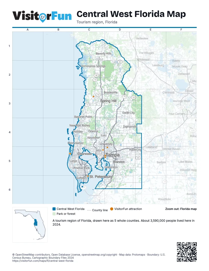
Highway index of Central West Florida
Each highway on the sheet and the grid squares it crosses.
- I-4D5, E5
- I-75D3, D4, D5, D6
- I-175C6
- I-275C4, C5, C6, D4, D5
- I-375C5
- US 19C1, C2, C3, C4, C5, C6
- US 41C4, D2
- US 92C5
- US 98C1, C2, D3
- SR 44C1, C2, D1, D2
- SR 50C3, D3, E3
- SR 54C4, D4
- SR 56D4
- SR 60C5, D5, E5
- SR 568C4
- SR 589C1, C2, C3, C4, C5
- SR 597C4
- SR 616C5
- SR 618C5, D5
- SR 686AC5
- SR 690C5
- SR 694C5
Things to do on the Central West Florida map
- Ballast Point Park
- Brooksville Railroad Depot Museum
- Busch Gardens Tampa Bay
- Clearwater Beach
- Clearwater Marine Aquarium
- Countryside Mall
- Egmont Key State Park
- Fort Cooper State Park
- Gulf View Square
- Hillsborough River State Park
- Imagine Museum
- International Plaza and Bay Street
- Lake Seminole Park
- Museum of Fine Arts, St. Petersburg
- Museum of Science & Innovation
- Seminole Hard Rock Hotel & Casino Tampa
- Sunken Gardens
- The Dalí Museum
- The Florida Aquarium
- Weeki Wachee Springs State Park
- Ybor City
- Zephyrhills Museum of Military History
- ZooTampa at Lowry Park
Places on the map
- Bayonet Point
- Beverly Hills
- Brandon
- Brooksville
- Clearwater
- Dade City
- Gibsonton
- Gulfport
- Holiday
- Homosassa Springs
- Keystone
- Largo
- Leto
- Lutz
- New Port Richey
- Odessa
- Palm Harbor
- Pinellas Park
- Plant City
- Spring Hill
- St. Petersburg
- Tampa
- University
- Zephyrhills
Next to Central West Florida
© OpenStreetMap contributors, Open Database License, openstreetmap.org/copyright · Map data: Protomaps · Boundary: U.S. Census Bureau, Cartographic Boundary Files 2024