

Florida map
Pinellas County map
About 965,870 people live here (Census Bureau, 2024 estimate). The sheet's index lists 7 streets; US Highway 19 North, Gateway Expressway and US 19 North cross the most grid squares. Things to do inside the boundary: Clearwater Beach, Clearwater Marine Aquarium and The Dalí Museum.
Open the map (PDF, US Letter)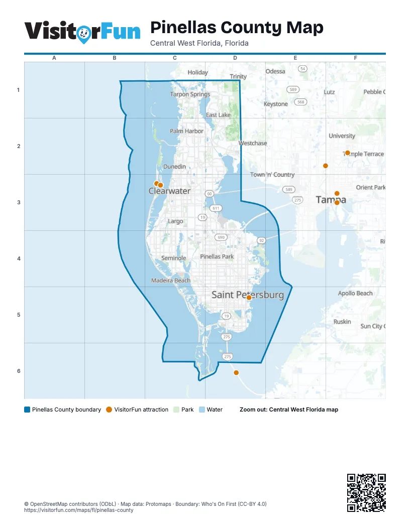
Maps inside Pinellas County
1 map inside, from the street map of Pinellas County down.
Street index of Pinellas County
Each street on the sheet and the grid squares it crosses.
- US 19 NorthC2
- US Highway 19 NorthC2, C3, D4
- US Highway 19 SouthC2
- Dillinger McCabe Bayside BridgeD3
- Gateway ExpresswayD3, D4
- Gandy BoulevardD4
- Sunshine Skyway BridgeD6
Things to do on the Pinellas County map
Places on the map
- Alligator Lake
- Bardmoor Country Club
- Bartow Power Plant
- Bay Pines
- Belleair
- Belleair Beach
- Belleair Bluffs
- Belleair Country Club
- Belleair Shore
- Boca Ciega Millennium Park
- Boyd Hill Nature Preserve
- Brooker Creek Preserve
- Caladesi Island State Park
- Clearwater
- Clearwater Executive Airport
- Countryside Country Club
- Crescent Oaks Country Club
- Dunedin
- Dunedin Golf Club
- Eagle Lake Park
- East Lake
- Feather Sound
- Feather Sound Country Club
- Fort De Soto County Park
- Fort DeSoto Park Campground
- Fred Howard Park
- Gandy
- Gulfport
- Hammock Park
- Harbor Bluffs
- Honeymoon Island State Park
- Indian Rocks Beach
- Indian Shores
- Innisbrook Golf Resort
- Isla Del Sol
- John Chesnut Sr. Park
- Kenneth City
- Lake Maggiore
- Lake Seminole
- Lake Seminole Park
Next to Pinellas County
- Apollo Beach
- Clair-Mel City
- Egypt Lake
- Gibsonton
- Holiday
- Keystone
- Lake Magdalene
- Leto
- Lutz
- Northdale
- Odessa
- Orient Park
- Palm River
- Pebble Creek
- Ruskin
- Sun City Center
- Tampa map
- Temple Terrace
- Town 'n' Country
- Trinity
- University
- Westchase
© OpenStreetMap contributors (ODbL) · Map data: Protomaps · Boundary: Who's On First (CC-BY 4.0)