

Florida map
Largo map
About 82,337 people live here (Census Bureau, 2024 estimate). The sheet's index lists 300 streets; Ulmerton Road, 2nd Street and 7th Street cross the most grid squares. Also on it: Aaron's, Advance Auto Parts and Applebee's.
Open the map (PDF, US Letter)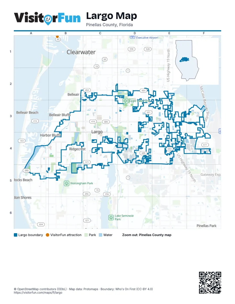
Street index of Largo
Each street on the sheet and the grid squares it crosses.
- US Highway 19 NorthE2, E3, E4
- Gateway ExpresswayF4
- Dillinger McCabe Bayside BridgeF4
- Ulmerton RoadB4, C4, D4, E4, F4, B5
- East Bay DriveC3, D3, E3
- Seminole BoulevardC3, C4
- Walsingham RoadA5, B5
- Roosevelt BoulevardE3, F3, F4
- West Bay DriveB3, C3
- US 19 Northbound Frontage RoadE2, E3, E4
- US 19 Southbound Frontage RoadE2, E3, E4
- 66th Street NorthE4
- Missouri Avenue NorthC2, C3
- 49th StreetF4
- South Missouri AvenueC2
- 1st Street SouthwestC3, C4
- Indian Rocks CausewayA5
- 49th Street NorthF4
- South Belcher RoadD2, D3, D4
- Starkey RoadD3, D4
- Ridge Road SouthC3, C4
- Indian Rocks RoadA4, B4, A5
- 113th StreetC4, C5
- Keene RoadD2, D3
- Belleair RoadC2, D2
- Clearwater Largo Road NorthC2, C3
- Clearwater Largo Road SouthC3, C4
- South Keene RoadD2
- Oakhurst RoadA5
- 8th Avenue SouthwestB3, C3
- 142nd Avenue NorthD4, E4, F4
- Highland AvenueC3, C4
- 137th StreetA4, A5
- 62nd Street NorthE3, E4
- 126th Avenue NorthB4, C4, D4, E4
- 58th Street NorthF3, F4
- 20th Street SouthwestB3, B4
- South Lake AvenueC2, D2, D3
- Vonn RoadB4, B5
- Wilcox RoadA4, B4
- 16th Avenue SouthwestB4, C4
- 150th Avenue NorthE4, F4
- Rosery Road NortheastC3
- Rosery Road NorthwestC3
- Ridge RoadC4, C5
- Central Park DriveC3
- Ponce de Leon BoulevardB2, C2
- South Highland AvenueC2, C3
- 131st Street NorthB5
- Lake Avenue NortheastC3, D3
- Whitney RoadE3, F3
- Dryer AvenueB4
- Donegan RoadC3, C4, D4
- Pine StreetB4
- 8th Avenue NorthwestC3
- Lake Avenue SoutheastD3, D4
- McMullen RoadD3
- Alt Keene RoadD3
- 8th Avenue SoutheastC3
- 119th Street NorthB4, B5
- Rosery Road EastC3, D3
- Gladys StreetB4
- Jasper StreetC3
- 130th Avenue NorthB4, C4
- Bolesta RoadF3
- South Martin Luther King Junior AvenueC2, C3
- South Indian Rocks RoadB3, B4
- 20th Street NorthwestB3
- Mehlenbacher RoadB3
- 134th AvenueB4
- Nursery RoadC2
- Wyatt StreetC2
- Wild Oaks WayD4
- Haines Bayshore RoadE3
- 162nd Avenue NorthF3
- 2nd StreetE2, C3, E3, C4, D4, E4
- 3rd StreetE2, C3, E3, D4, E4
- 1st StreetE2, C3, E3, D4, E4
- Bay Vista DriveF3
- 4th StreetE2, C3, E3, E4
- 5th StreetE2, C3, E3, E4
- 7th StreetE2, B3, C3, E3, C4, E4
- Royal Palm CircleC4
- 6th StreetE2, C3, E3, C4, E4
- Tall Pines DriveD4
- Reserve At ClearwaterE4
- Lake DriveC3, E4, B5
- 8th StreetE2, E3, C4, E4
- Fairway BoulevardD4
- 9th StreetE2, E3, C4, E4
- 6th Avenue SouthwestB3, C3
- 7th Avenue SouthwestB3, C3
- 10th Street NorthwestB3, C3
- Keene Park DriveD3
- Country Club DriveC3, D3, D4
- Kent PlaceD3, E3
- Belcher RoadD3
- Long Bow LaneD2, D3
- 4th Avenue NorthwestB3, C3
- Trotter RoadB3, B4
- Adrian AvenueB4
- Hospic CircleF3
- 6th Street NorthwestC3
- BonaireD4
- Washington AvenueC4
- Imperial Palm CourtD3
- Pindo Palm Street WestC4
- Roberta StreetD3
- 1st Avenue NorthwestB3, C3
- Hillsdale AvenueB4
- Foxbridge Circle NorthF3
- Wild Acres RoadD4
- 8th Avenue NortheastC3
- Alvarado AvenueE4
- Shoreline DriveF3
- 14th Avenue SouthwestB4, C4
- Lake Palm DriveD3, D4
- Seacrest DriveD3
- 10th Street SouthwestB3, B4
- 4th Avenue SouthwestB3, C3
- Croft DriveA5, B5
- Oak Manor LaneA4, B4
- Pindo Palm Street EastC4
- South Betty LaneC2, C3
- 2nd Street SouthwestC3, C4
- Pine BoulevardE4
- Boyette CircleB4
- 3rd Avenue NorthwestB3, C3
- 7th Avenue NortheastC3
- Granada AvenueD4, E4
- 143rd StreetA4, A5
- Whitney WayE3
- Lakeside DriveB4, C4, E4
- Icot BoulevardF4
- 3rd Avenue SouthwestB3, C3
- Saint Pauls DriveD2, D3
- Heron RoadE4
- 10th StreetE3, F3, E4
- Lake RoadE4
- 1st Avenue SouthwestC3
- Thatch Palm Street EastC4
- Golden Gate DriveC3
- Cleveland AvenueC3
- 2nd Avenue NortheastC3
- 1st Avenue NortheastC3
- 5th Avenue NortheastC3
- Thatch Palm Street WestC4
- 2nd Avenue SouthwestB3, C3
- 6th Street NortheastC3
- 4th Street NorthwestC3
- Cambridge DriveC2, C3
- 14th Street NorthwestB3
- 4th Street SouthwestC3
- Fulton DriveD3
- 11th Street NorthwestB3
- 7th Street NorthwestC3
- Parkview LaneB3, B4
- East Rosery RoadD3
- 2nd Avenue NorthwestB3, C3
- Melody LaneD3, D4
- Gershwin DriveD3
- Ridge Road SouthwestC3
- Emerald LaneD3
- 124th Avenue NorthB5, C5
- 1st AvenueB3, C3, C4
- Alicia WayE3
- King StreetC4
- 13th Avenue SouthwestB4, C4
- Whitting CourtC4
- 6th Avenue NortheastC3
- Crown CircleD4, E4
- 10th Avenue SouthwestB4, C4
- Sabal Palm DriveC4
- 126th AvenueA4, B4
- Mary Sue StreetB4
- 14th Avenue NorthwestB3, C3
- 13th Avenue NorthwestB3, C3
- 128th Avenue NorthB4, C4
- 20th Avenue SouthwestB4
- 22nd Street SouthwestB3, B4
- Valencia WayD3
- Beverly Avenue NorthwestB3, C3
- Crescent DriveB3, B4
- 122nd Avenue NorthA5, C5
- Thoroughbread LoopD4
- 15th Avenue NorthwestB3, C3
- Stratford DriveC2, D3
- 5th Avenue SouthwestC3
- 111th Lane NorthC4, C5
- Circle DriveC3, C4
- Wrens WayD2, D4
- 5th Street NorthwestC3
- 4th Street NortheastC3
- Ranchero BoulevardE4
- 6th Avenue SoutheastC3, D3
- Forest Parkway NorthD3
- Forest Parkway SouthD3
- 19th Place SouthwestB4
- Huntington DriveD3
- Lancaster DriveD3, E3
- El Camino CourtD3
- Beechwood LaneC3
- 15th StreetE3, F3, C4
- 127th PlaceC4
- Havana AvenueD4, E4
- Nolan Drive SouthwestB3, B4
- 129th Terrace NorthB4, C4
- El Centro Boulevard WestE4
- Bluffs DriveB3
- 12th StreetE3, F3, D4
- Myerlake CircleF4
- Imperial DriveD3
- 6th Avenue NorthwestB3, C3
- Belleair PlaceC2
- Chesterfield DriveC2, C3
- Whispering Drive SouthD4
- East Deville DriveD3
- 16th Avenue NorthwestB3, C3
- 127th Avenue NorthA4, B4, C4
- 122nd AvenueC5
- 145th Street NorthA4, A5
- East Overbrook DriveB3
- Forest Parkway EastD3
- Saint Thomas WayD4
- Central AvenueE3
- Riverside Drive NorthD3, E3
- 36th Street SoutheastD3
- 9th Street NorthwestC3
- Briarwood DriveE3
- Bogie Road NorthD4
- 144th StreetA5
- 6th Street SouthwestC3
- Frangipani CircleC4
- Whispering Drive NorthD4
- 11th Avenue SouthwestB4, C4
- 11th Street SouthwestB3
- Village BoulevardD4, E4
- Ashbury DriveE3
- 14th StreetE3, F3, C4
- 126th Terrace NorthB4, C4
- 127th AvenueC4
- 16th Avenue SoutheastC4
- 3rd Street NorthwestC3
- Sandpiper DriveD3
- Cork StreetC3
- Shore DriveD3
- 114th Street NorthC4
- 130th AvenueC4, D4
- Palm IslandD4
- 11th StreetE3, C4, D4
- Sunny Breeze AvenueB4
- 115th Street NorthC4
- Robin Hood LaneD2
- Willowbrook DriveD3, E3
- Egret DriveD3
- Kings Point DriveA4
- San Miguel DriveE4
- Corvett DriveD3
- Idle Drive NortheastC3, D3
- 5th Avenue NorthwestB3, C3
- Hidden Oaks CircleE4
- Nassau LaneD4
- 8th Street NortheastC3
- 71st Street NorthE4
- Cameo WayC3
- 10th Avenue NorthwestB3, C3
- Christie DriveD4
- Point West WayC4
- Willow AvenueD3, D4
- Eagle Drive EastD4
- 12th Street SouthwestB3, B4
- Eagle Drive WestD4
- 15th Street NorthwestB3
- Parakeet LaneC3
- 3rd AvenueC3, C4
- Meadow Lake AvenueD3
- Harmony DriveD3
- Leona DriveB3, B4
- Amhurst WayD3, E3, E4
- 61st Street NorthE3, E4
- Queen PalmC4
- 2nd AvenueB3, C3, C4
- Georgianna StreetB4
- Bedford Circle WestE3
- South Pines DriveD4
- Harbor Lake DriveB4
- Auburn StreetC2
- Martinique LaneD4
- Caerleon RoadE3
- King Palm StreetC4
- Meadow View AvenueD3
- Sago Palm StreetC4
- 17th StreetE3, F3
- Ridge Road NorthC3
- Highland Avenue SoutheastC4
- 21st Avenue SouthwestB4
- 144th LaneA5
- 145th Lane NorthA5
- 21st Place SouthwestB4
- Coastal Ridge RoadC4
Places on the map
- Aaron's
- Advance Auto Parts
- Applebee's
- AutoZone
- Bank of America
- Bayhead Action Park
- Bible Fellowship Church
- CarMax
- Chase
- Chili's
- Country Pizza Italian Grill
- CVS Pharmacy
- Datsko Park
- Denny's
- Eagle Lake Park
- East Bay Golf Club
- Famous Tate
- Fifth Third Bank
- Flagship Bank
- Four Lakes at Clearwater
- George C. McGough Nature Park
- Giovanni's Bakery
- Goodyear
- Hammock Hardware
- Hampton Inn & Suites
- HCA Florida - Largo Hospital
- Hungry Crab
- In Town Suites
- Indian Oaks Manor
- Keene Park Shopping Center
- Keene Plaza
- KIOS Group USA
- Largo Central Park
- Largo Fire Rescue
- Largo Golf Course
- Largo Mall
- Largo Public Library
- Serenity Gardens Memorial Park
- Taylor Lake
- Taylor Park
Next to Largo
- Belleair
- Belleair Beach
- Belleair Bluffs
- Belleair Shore
- Clearwater map
- Harbor Bluffs
- Indian Rocks Beach
- Indian Shores
- Pinellas Park
- Ridgecrest
© OpenStreetMap contributors, Open Database License, openstreetmap.org/copyright · Map data: Protomaps · Boundary: Who's On First (CC-BY 4.0)