

Florida map
St. Augustine map
About 16,033 people live here (Census Bureau, 2024 estimate). The sheet's index lists 300 streets; North Ponce de Leon Boulevard, Anastasia Boulevard and Pellicer Lane cross the most grid squares. Things to do inside the boundary: Castillo de San Marcos National Monument, Anastasia State Park and Fort Mose Historic State Park.
Open the map (PDF, US Letter)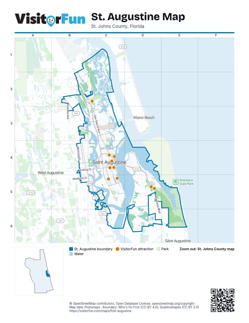
Street index of St. Augustine
Each street on the sheet and the grid squares it crosses.
- North Ponce de Leon BoulevardB2, C2, C3, C4
- Anastasia BoulevardC4, D4, D5, E6
- San Marco AvenueC3, C4
- South Ponce de Leon BoulevardC4, C5
- Cordova StreetC4, C5
- Avenida MenendezC4
- West King StreetB4, C4
- King StreetC4
- Bella Vista BoulevardC3
- Lewis SpeedwayB2, B3
- Charles Usinas Memorial HighwayC3
- May StreetC3
- Vilano CausewayC3
- Dixie HighwayC5, C6
- Bridge of LionsC4
- South Castillo DriveC4
- Ponce de Leon BoulevardC2, C4
- Cathedral PlaceC4
- West San Carlos AvenueC3
- Vilano CrosswayC3
- Anderson CircleC4
- A1A Beach BoulevardE6
- South Dixie HighwayC5
- West Castillo DriveC4
- San Sebastian ViewB2
- Pellicer LaneB4, C4, C5
- Picolata RoadC3
- Old Dixie HighwayC5
- Old A1A SouthE6
- Riberia StreetC4, C5
- Palmer StreetB4
- Masters DriveB3, B4
- Marine StreetC4, C5
- Martin Luther King Jr AvenueC4, C5
- Inlet DriveD4
- North Saint Augustine BoulevardD4
- South Whitney StreetB4, B5
- Comares AvenueD4
- South StreetC5
- Evergreen AvenueB4, C4
- Varella AvenueB2, B3
- Malaga StreetC4
- Ravenswood DriveB4
- Evergreen StreetB4
- Saint Augustine BoulevardD4
- Anastasia Park RoadD5, E5, E6
- Arricola AvenueD4, D5
- North Whitney StreetB4
- Vista Cove RoadB3, C3
- Charlotte StreetC4, C5
- Spring StreetB4
- Maralinda DriveB2, C2
- Coquina AvenueD4, D5
- Campground RoadE5, E6
- Plantation Island Drive SouthD6
- Saint George StreetC4, C5
- Harbour Vista CircleD6
- Arredondo AvenueD4
- Pelican Reef DriveD5
- Nesmith AvenueB4
- Menendez RoadD4, D5
- Pescado DriveB1, B2
- South Matanzas BoulevardD4, D5
- Oneida StreetC4, C5
- Washington StreetC4, C5
- Pantano DriveC1, C2
- Anastasia Lakes DriveD6
- Bridge StreetC4, C5
- Douglas AvenueC3
- Orange StreetC4
- Pintoresco DriveB2
- Santander StreetE6
- Flagler BoulevardD4
- Spartina AvenueD5
- Big Joe LaneB3
- Anderson StreetB5, C5
- Dolphin DriveD4
- Lewis BoulevardC4, C5
- Oglethorpe BoulevardD4
- Magnolia AvenueC3, C4
- Arpieka AvenueD4
- Alcarzar StreetD4
- Madeore StreetB5, C5
- Zorayda AvenueD4
- Arapaho AvenueC5
- Portada DriveB2
- Fullerwood DriveC3
- Lamengo LaneB2, C2
- Julia StreetB4, C4
- West Marina Cove DriveD6
- Saint Francis StreetC4, C5
- Valencia StreetC4
- Carrera StreetC4
- Red Cox DriveD5
- Sevilla StreetC4
- Magnolia DriveD4, D5
- Helen StreetB4, C4
- Mizell RoadD6
- Lions Gate DriveD6, E6
- Saragossa StreetC4
- Plaza del Rio DriveB2
- Pasarela DriveB2, C2
- Avery StreetB4
- Bay View DriveC3
- Florida AvenueB4, C4
- East Marina Cove DriveD6
- Grant StreetC3
- Five Is DriveD5, D6
- Miruela AvenueD4
- Lew BoulevardD5
- Sirena CircleB3, B4
- Dufferin StreetC3
- Sidney StreetB4, B5
- Macaris StreetC3
- Sand Dollar Campground LoopE5
- Avista CircleD4
- Casanova RoadD5
- Shark Eye Campground LoopE5
- Ponce Island DriveB2, C2
- Josiah StreetB4
- Theodore StreetB4
- Coquina Campground LoopE6
- Woodcrest DriveB2, B3
- East San Carlos AvenueC3
- Water StreetC4
- Blanco StreetC5
- Grove AvenueC4
- Twine StreetC5
- Spanish StreetC4
- Palmetto AvenueD4, D5
- Emergency / Staff Service RoadE5
- Oyster Catcher CircleD5
- Paranza TraceB2
- Lasa DriveB2
- Rohde AvenueC4
- Sylvan DriveC3
- East Park AvenueC3
- Cedar StreetC4
- Park Terrace DriveD5
- Old Quarry RoadD5
- Sanford StreetC4, C5
- Salida WayB1, B2
- John StreetB5
- Sea Bean Campground LoopE5
- Chapin StreetB4
- Leeward Island DriveD5, D6
- Milton StreetC3
- De Haven StreetC5
- Sea Urchin Campground LoopE5
- Queen Conch Campground LoopE5
- San Juan DriveE6
- Cincinnati AvenueC4
- Pearl StreetB4
- Whispering Brook DriveB2
- Fish Island RoadD6
- North Park AvenueC3
- Nelmar AvenueC3
- Lovett StreetC5
- Duero StreetC5
- East LaneC4
- Carver Street WestD5
- Gerado StreetD4
- Rio Vista DriveC5
- Atlantic AvenueC3
- Kings Ferry WayC5
- Lincoln StreetC5
- Hope StreetC4
- Phillips StreetB5
- Grande Vista BoulevardC3
- Hildreth DriveC3
- Smith StreetB4
- Weeden StreetC4, C5
- Park PlaceC5
- Pine StreetC4
- Solano AvenueD5
- Bernard StreetC4
- Hybiscus AvenueB2, C2
- Andreas StreetD4
- Arenta StreetC4
- Employee Service RoadE5, E6
- Flamingo DriveD5
- Old Mission AvenueC4
- Angel Wing Campground LoopE5
- Hypolita StreetC4
- Tesoro TerraceC1, C2
- Locust StreetC4
- South Comares AvenueD4, D5
- Islander DriveD6
- Ferdinand AvenueD5
- Hannah Cole DriveD6
- Willard DriveC6
- Granada StreetC4
- Beacon StreetC3
- Islander CircleD6
- Pauls AlleyD5
- Sebastian Harbor DriveC4
- School House RoadB3
- Baru RoadD5
- Christopher StreetB4, B5
- Mulberry StreetC4
- Sunset Circle SouthD6
- Sebastian AvenueC4
- Sunset Circle NorthD6
- Busam StreetD5
- Colon AvenueC2
- Mc Millan StreetC3
- Moultrie PlaceD4
- Ocean AvenueC4
- Bruen StreetB4
- Cerro StreetC5
- Hernandez BoulevardD5
- Spencer StreetC5
- Cuna StreetC4
- Herada StreetD5
- Zoratoa AvenueD4
- Leonardi StreetB4, C4
- M L King AvenueC5
- Nix Boat Yard RoadC5
- Williams StreetC3
- Loring StreetC4
- Shenandoah StreetC4
- Minorca AvenueD4
- Abbott StreetC4
- Osceola StreetC4
- Seminole DriveC3
- Joiner StreetC4
- Spoonbill Point CourtD5
- Carey StreetC5
- Pacific StreetC3
- Sanchez AvenueC4
- Kenan StreetD5
- Aviles StreetC4
- Montrano AvenueD4
- North Matanzas BoulevardD4
- Rollins AvenueB4
- Center StreetC3
- Clark StreetC4, C5
- Lighthouse AvenueD4, D5
- Treasury StreetC4
- Vedder StreetC3
- Iroquois AvenueC5
- Oak StreetC3
- San Rafael RoadE5
- White Street EastD4, D5
- Mackey LaneB4
- Ancient Island DriveD6
- Amarante LaneB2, C2
- Ballard AvenueC3
- Ribault StreetD4
- Davis StreetC4
- Fairbanks StreetC3
- Gabriel StreetC3
- Garnett AvenueC3
- Anastasia Park DriveD5
- Diesel RoadC5
- Louise StreetC3
- D O T RoadB2
- Ovieda StreetC4
- Althea StreetC3
- Genoply StreetC3
- Frontera DriveB2
- Bannon AvenueC3
- Cunningham AvenueC3, C4
- River RoadC5
- Pajaro WayB1
- Dayllon AvenueD4
- Desoto PlaceC4
- Isabel StreetB5, C5
- Almeria StreetC4
- Marina Cove DriveD6
- Moore StreetC5
- Nesbit AvenueB4
- Newcomb StreetB5
- Staff Service RoadE6
- Tesora TerraceB1, C1
- BusesC4
- Eastman StreetB5
- Carver Street EastD5
- Emergency Service Road / Staff Service RoadE5
- Institute StreetC3
- Pomar StreetC5
- Matanzas AvenueC3
- Railroad AvenueB4
- Rainey AvenueC3
- Gault StreetC3
- 1st StreetC4
- Lemon StreetC4
- Perpall StreetC3
- Cadiz StreetC4
- Waldo StreetC3
- La Quinta PlaceC4
- Aviles DriveC5
- Markland PlaceC4
- Saint Barts AvenueD6
- Aqua Vista LaneC3
- Inlet PlaceD4
- Red House CircleB2
- Alerto StreetD5
- Columbus StreetC5
- Estey StreetC3
Things to do on the St. Augustine map
- Castillo de San Marcos National Monument
- Anastasia State Park
- Fort Mose Historic State Park
- Lightner Museum
- Lincolnville Museum and Cultural Center
- Spanish Military Hospital Museum
- St. Augustine Alligator Farm Zoological Park
- St. Augustine National Cemetery
- St. Augustine Visitor Information Center
- St. George Street
Places on the map
- 8 Limbs Yoga
- A&R Auto Electric
- Ace Hardware
- Alpha Omega Thrift Store
- American Alligator Area
- Ameris Bank
- Anastasia Inn
- Anastasia Miniature Golf
- Anastasia Park Road
- Ancient City Baptist Church
- Angela's Restaurant Supply
- Archeological Exhibit
- Arnold's Lounge
- Art'nMotion
- AutoZone
- Avid Angler
- Bank of America
- Bayfront Inn
- Bayfront Marin House
- Bayfront Mini Golf
- Bayfront Westcott House Bed and Breakfast
- Bayview Samantha R. Wilson Care Center
- Best Western Bayfront
- Best Western Historical Inn
- Big Bill's Die Cast
- Conch House Marina
- Eddie Vickers Park
- Florida School for the Deaf and the Blind
- Gates of Saint Johns
- Lewis Auditorium
- Lincolnville Historic District
- Mission Nombre de Dios
- Pomar Park
- R.B. Hunt Elementary School
- Rivers Edge Marina
- Saint Augustine
- Saint Augustine Amphitheatre
- Saint Augustine City Hall
- Saint Augustine Marine Center
- Shipping Plus
Next to St. Augustine
- Vilano Beach
- West Augustine
© OpenStreetMap contributors, Open Database License, openstreetmap.org/copyright · Map data: Protomaps · Boundary: Who's On First (CC-BY 4.0); Quattroshapes (CC BY 2.0)















