

Iowa map
Dubuque Township map
About 58,987 people live here (Census Bureau, 2024 estimate). The sheet's index lists 204 streets; Derby Grange Road, John F. Kennedy Road and Seippel Road cross the most grid squares. Also on it: Althaus Pond, Althaus Pond Trail and Althaus Wetland and Nature Preserve.
Open the map (PDF, US Letter)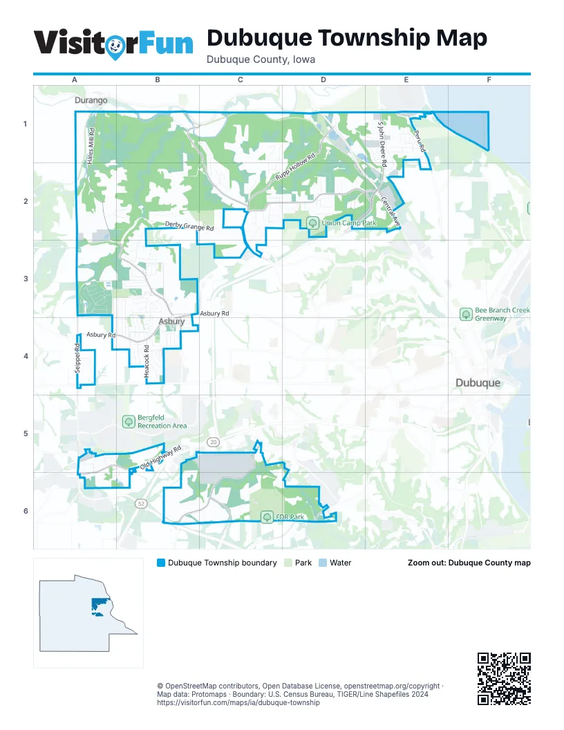
Street index of Dubuque Township
Each street on the sheet and the grid squares it crosses.
- Burton Furnace RoadA1, B1
- Burtons Furnace RoadA1
- Hales Mill RoadA1, A2, B3
- Access RoadB1, C1
- Clay Hill RoadB1, C1, C2
- Araglin CourtC1
- Ballymore LaneC1, C2
- Carina CourtC1, C2
- Castlemaine LaneC1, C2
- Emerald DriveC1, C2
- Dayflower StreetD1, D2
- Dayton StreetD1
- Deere StreetD1
- Elain StreetD1
- Ledgewood DriveD1
- Rupp Hollow RoadD1, C2, D2
- Sageville RoadD1
- Splinter StreetD1
- Timber Ridge StreetD1, E1
- Boleyn RoadE1
- Breiner DriveE1
- Charlies LaneE1
- Cinnamon RoadE1, E2
- Daisy Hill LaneE1
- Dee Lee DriveE1, E2
- Diesel DriveE1
- Dixie DriveE1
- Edmore LaneE1
- Eli DriveE1
- Emberwood DriveE1
- Flynn DriveE1
- Four Mounds LaneE1
- Gardners LaneE1, E2
- Ginger RidgeE1
- Gondola DriveE1
- Jolene LaneE1
- Melody CircleE1, E2
- Mels CourtE1
- New Ridge RoadE1
- Pepper LaneE1, E2
- Peru RoadE1, E2
- Rio Vista DriveE1
- River Vista CourtE1
- River Vista DriveE1
- Riverside RoadE1
- South John Deere RoadE1, E2
- Timberview CourtE1
- Vista DriveE1
- Cedar Ridge RoadA2
- Derby Grange RoadA2, B2, C2, A3, B3
- Elly Rose CourtA2, B2
- Hales Mill CourtA2
- Keegan CourtA2, B2
- Mill Ridge RoadA2, B2
- Country View CourtB2
- Country View DriveB2
- Cypress PointB2
- Herod LaneB2, C2
- Starr PassB2, B3
- Surrey LaneB2
- Woodmoor DriveB2, B3
- Barnwood LaneC2
- Barony DriveC2, C3
- Brittany CourtC2
- County Road 734C2
- Coventry LaneC2
- Eton CircleC2
- Forest Gate RoadC2
- Forest Glen CourtC2
- Forest Meadow DriveC2
- Hidden RidgeC2
- John F. Kennedy RoadC2, D2, E2, C3
- Kingston WayC2, C3
- Lime Rock LaneC2
- Lismore LaneC2
- Noble RidgeC2
- Northern Hills DriveC2
- Oak Brook PlaceC2
- Rugby CourtC2
- Rustic Forest TrailC2
- Rustic Point LaneC2
- Schlitzer LaneC2
- Sterling Oaks CourtC2
- Timber CourtC2
- Aspen Meadow CourtD2
- Breckenridge CourtD2
- Cedar HillD2
- Cherrywood Hills DriveD2
- Chicory StreetD2
- Chloe Mae LaneD2
- Corey Daniel CourtD2
- Daisy TrailD2
- Deer Valley TrailD2
- King Arthur CourtD2
- Muntz CourtD2
- Northwest ArterialD2, E2
- Nottingham CourtD2
- Robin Hood DriveD2
- Rolling Hills EstatesD2
- Sanders LaneD2
- Union Park LaneD2
- Wittman Hamm CourtD2
- Central AvenueE2
- Collision DriveE2
- Mount Vail RidgeE2
- Ski Park LaneE2
- Tanzanite DriveE2
- Amber Ridge DriveA3
- Apache CourtA3
- Forest Hills DriveA3
- Glen Eagle CourtA3
- Lenore LaneA3
- Lynbrook DriveA3
- Pinehurst CourtA3
- Seippel RoadA3, A4, A5, A6
- Seven Springs DriveA3
- Spruce Wood DriveA3, A4
- Stockwood DriveA3
- Stonebriar CourtA3
- Valley Wood CourtA3
- Willow Wood DriveA3, B3
- Willowbrook DriveA3
- Winterwood DriveA3
- Antler Ridge DriveB3, B4
- Asbury RoadB3, A4, B4
- Augusta CourtB3
- Autumn DriveB3
- Birchwood DriveB3, B4
- Briarwood DriveB3, B4
- Brick Mason LaneB3
- Brook Hills DriveB3
- Brook Hollow DriveB3
- Brook Meadows CourtB3
- Canterbury CourtB3
- Double Eagle DriveB3
- Heatherwood CourtB3
- Maplewood DriveB3, B4
- Park PlaceB3
- Pebble Beach DriveB3
- Radford RoadB3, B4
- Sage Valley CourtB3
- Sagewood DriveB3
- Sandestin DriveB3
- Sanibel LaneB3
- Springreen DriveB3, B4
- Summer DriveB3
- Sun RidgeB3
- Sun Valley DriveB3
- Sunset DriveB3
- Whitetail DriveB3, B4
- Wintergreen DriveB3, B4
- Berry LaneA4
- Catalpa StreetA4, B4
- Centura CourtA4
- East View StreetA4, B4
- Osage DriveA4
- Pennsylvania AvenueA4
- Sandpiper LaneA4
- Asbury CircleB4
- Asbury Court PlaceB4
- Asbury Heights PlaceB4
- Asbury MeadowsB4
- Burr Oak DriveB4
- Carver DriveB4
- Crown Point RoadB4
- Dearborn DriveB4
- Doe Run DriveB4
- Eldie DriveB4
- Fawnview DriveB4
- Grand Meadow DriveB4
- Green Crest CourtB4
- Heacock RoadB4
- Helle DriveB4
- Indy DriveB4
- Irina CourtB4
- Jill DriveB4
- Jo Ann DriveB4
- Jodi CourtB4
- Julia DriveB4
- Meadow CourtB4
- Northwood CourtB4
- Parkside DriveB4
- Rolling Hills PointB4
- Saratoga RoadB4
- School View DriveB4
- Trenton RoadB4
- Valley Forge RoadB4
- Water View LaneB4
- Yorktown RoadB4
- Fairgrounds Exit 2 RoadA5
- Fairgrounds Exit 4 RoadA5
- Fairgrounds RoadA5, B5
- Julien LaneA5, A6
- Old Highway RoadA5, B5, A6
- Public Safety WayA5
- Cousins RoadB5, B6
- Pine View DriveB5, A6, B6
- English Mill RoadC5, B6, C6
- Nightengale LaneC5, D5
- Southwest ArterialB6
- North English RoadC6
- Creekwood DriveD6
- Miners LaneD6
- North Cascade RoadD6
Places on the map
- Althaus Pond
- Althaus Pond Trail
- Althaus Wetland and Nature Preserve
- Asbury
- Asbury City Hall
- Asbury Community Fire Department
- Asbury Methodist Cemetery
- Asbury Park
- Asbury PD
- Brook Haven Park
- Casey's General Store
- Clay Ridge Park
- Cloie Creek Park
- Couler Valley RV
- Derby Grange Golf & Recreation Center
- Dubuque County Fairgrounds
- Dubuque Shooting Society
- Dubuque Sports Complex
- Emergency Site
- FDR Park
- Forest Hills Pond
- Frog Hollow
- Hawkeye Care Center
- Heritage Campground & Pond
- Heritage Marsh Wildlife Area
- Heritage Pond
- Iowa Depository
- Jumble Coffee Co.
- Maple Hills Park
- Midwest Maintenance
- Resurrection Cemetery
- Rhody's Food 7 Spirits
- Silver & Gold Exchange
- Tonic Salon & Day Spa
- TRAINING FACILITY
- Tri-State Modelers
- Union Camp Park
- Wagner's Nursery
Next to Dubuque Township
- Dubuque map
- Durango
© OpenStreetMap contributors, Open Database License, openstreetmap.org/copyright · Map data: Protomaps · Boundary: U.S. Census Bureau, TIGER/Line Shapefiles 2024