

Iowa map
Lee County map
About 32,376 people live here (Census Bureau, 2024 estimate). The sheet's index lists 79 streets; Main Street, State Highway 16 and Avenue of the Saints cross the most grid squares. Also on it: Amborn-Pagin Wildlife Area, Boulevard Place and Cedar Township.
Open the map (PDF, US Letter)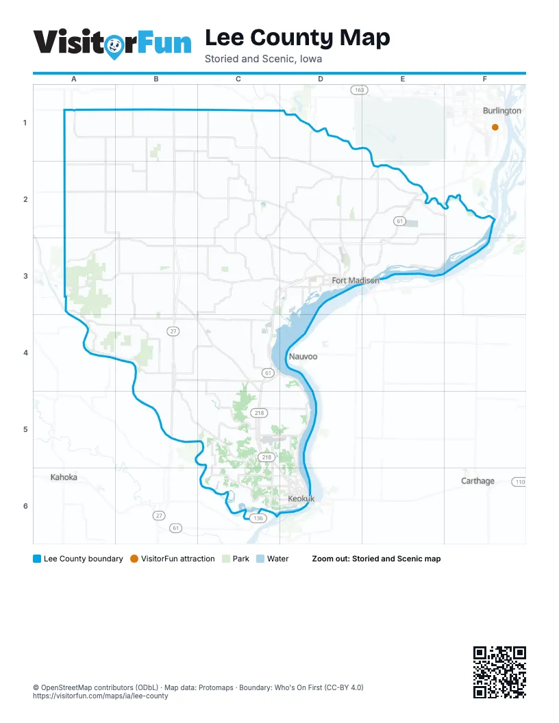
Maps inside Lee County
1 map inside, from the street map of Lee County down.
Street index of Lee County
Each street on the sheet and the grid squares it crosses.
- 100th AvenueA1, A2
- Ash AvenueA1
- Henry Lee StreetA1
- State Highway 16A1, B1, C1, D1, D2
- 130th StreetB1, C1
- Avenue of the SaintsB1, B2, B3, B4, B5
- Main StreetB1, C1, C4, D4, C5, D6
- Pilot Grove RoadB1, B2
- 205th AvenueC1
- 240th AvenueC1, C2
- Locust StreetC1
- 160th StreetA2, B2
- State Highway 103B2, C2
- 5th StreetC2
- 7th StreetC2
- Avenue DC2
- County Road J40C2, D2, D3
- Franklin RoadC2, C3
- West Point RoadC2, C3
- 303rd AvenueD2, D3
- Academy AvenueD2
- 175th StreetE2
- 330th AvenueE2, D3, E3
- 354th AvenueE2, D3, E3
- 71st StreetE2
- Perkins RoadE2
- Croton RoadA3, A4, B4
- State Highway 2A3, B3, C3, D3
- 180th AvenueB3, B4
- 200th StreetB3, C3
- Madison AvenueB3
- North Main StreetB3
- South Main StreetB3
- Broadway StreetC3
- 15th StreetD3
- 18th StreetD3
- 20th StreetD3
- 24th StreetD3
- 2nd StreetD3
- 48th StreetD3
- 6th StreetD3
- 9th StreetD3
- Avenue AD3
- Avenue ED3
- Avenue GD3
- Avenue HD3
- Avenue LD3
- Avenue ND3
- Avenue OD3
- Bluff RoadD3
- County Road X32D3
- Fort Madison BridgeD3, E3
- Old Highway 61D3
- 148th AvenueB4
- 255th StreetB4, C4
- 285th StreetB4
- 300th StreetB4, C4
- Argyle RoadB4, B5, C5
- Mississippi River RoadC4, D4, D5
- Elm StreetD4
- North 1st StreetD4
- Pine StreetD4
- River RoadD4, D5, D6
- South 1st StreetD4
- South Tesson StreetD4
- Water StreetD4
- 243rd AvenueC5
- 340th StreetC5, D5
- 353rd StreetC5
- 270th AvenueD5, D6
- Johnson Street RoadC6, D6
- South 7th StreetC6, D6
- Grand AvenueD6
- High StreetD6
- Keokuk-Hamilton BridgeD6
- North 5th StreetD6
- Plank RoadD6
- Rand Park TerraceD6
- South 25th StreetD6
Places on the map
- Amborn-Pagin Wildlife Area
- Boulevard Place
- Cedar Township
- Central Lee Community School
- Charleston Township
- Chatfield Park
- Chevron Chemical Company
- Climax Molydenum
- Denmark Township
- Des Moines River
- Des Moines Township
- Donnellson
- Elks Fairview Golf Club
- Fort Madison
- Fort Madison Middle School
- Fort Madison Municipal Airport
- Franklin
- Franklin Township
- Green Acres Country Club
- Green Bay Township
- Harrison Township
- Heron Bend Conservation Area
- Houghton
- Indian Hills
- Iowa State Penitentiary
- Jackson Township
- Jefferson Township
- Keokuk
- Keokuk Country Club
- Keokuk Municipal Airport
- Koch Fertilizer
- Lee County
- Lee County Speedway
- Lock & Dam No. 19
- Lotus Flats Conservation Area
- Madison Township
- Marion Township
- McDowell Lake
- Montrose
- Montrose Township
Next to Lee County
- Burlington
- Carthage
- Kahoka
- Nauvoo
- West Burlington
© OpenStreetMap contributors (ODbL) · Map data: Protomaps · Boundary: Who's On First (CC-BY 4.0)