

Illinois map
Forest Park map
About 13,846 people live here (Census Bureau, 2024 estimate). The sheet's index lists 66 streets; Circle Avenue, Des Plaines Avenue and Lathrop Avenue cross the most grid squares. Also on it: Concordia Cemetery, CTA Desplaines Yard and Forest Home Cemetery.
Open the map (PDF, US Letter)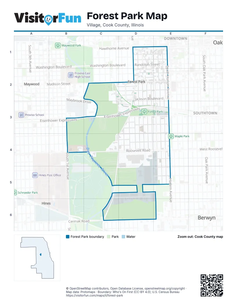
Street index of Forest Park
Each street on the sheet and the grid squares it crosses.
- Belvidere AvenueD1, E1
- Brown AvenueD1, D2
- Circle AvenueD1, E1, D2, E2, E3, E4, E5
- Des Plaines AvenueD1, D2, D3, C4, D4, C5, C6
- Dixon StreetD1, E1
- Franklin StreetD1, E1
- Hawthorne AvenueD1
- Lathrop AvenueD1, D2, D3, D4, D6
- Lincoln CourtD1
- Linden StreetD1
- Randolph StreetD1, E1
- Rockford AvenueD1, D2
- Washington BoulevardD1, E2
- Elgin AvenueE1, E2, E3, E4, E5
- Marengo AvenueE1, E2, E3, E4, E5
- Pleasant StreetE1
- South BoulevardE1
- South Harlem AvenueE1, E2, E3, E4
- Grove LaneC2, D2, D3
- Monroe StreetC2, D2, E2
- Park AvenueC2
- Van Buren StreetC2, C3, D3
- Adams StreetD2, E2
- Beloit AvenueD2, D3, D4
- Bergman CourtD2
- Burkhardt CourtD2
- Ferdinand AvenueD2, D3, D4
- Franklin AvenueD2
- Hannah AvenueD2, D3, D4, D5, E5
- Jackson BoulevardD2, E2
- Madison StreetD2, E2
- Rockford CourtD2
- Thomas AvenueD2, D3, D4
- Vine StreetD2
- Warren AvenueD2, E2
- Washington StreetD2, E2
- Wilcox StreetD2
- Eisenhower ExpresswayB3, C3, D3, E3
- Lexington StreetB3, D3, E3
- South 1st AvenueB3, B4
- Dunlop AvenueD3, D4
- Harrison StreetD3, E3
- Harvard StreetD3, E3, B4, D4
- Lehmer StreetD3, E3
- Polk StreetD3
- Troost AvenueD3, D4
- York StreetD3
- Garfield StreetE3
- Fillmore StreetB4, D4, E4
- Miller Meadow-North Access RoadB4
- Roosevelt RoadB4, C4, D4, E4
- Taylor StreetC4, D4
- Yuba StreetC4, D4
- 13th StreetE4
- Harlem AvenueE4, E5
- West Roosevelt RoadE4
- Greenberg RoadC5, D5
- Industrial DriveC5, D5
- 15th StreetD5, E5
- Abraham RoadD5
- Rebecca AvenueD5
- Sarah AvenueD5
- 14th StreetE5
- 16th StreetE5
- Jacob RoadE5
- Cermak RoadC6, D6, E6
Places on the map
- 1215 S Harlem Plaza
- 7-Eleven
- Altenheim Cemetery
- Blower
- Chicago Bulk Mail Center
- Chicagoland Christian Center
- Circle Bowling Lanes
- Concordia Cemetery
- CTA Desplaines Shop
- CTA Desplaines Yard
- CTA Harlem Shop
- CTA Harlem Yard
- Currie Motors Chevrolet
- Doc Ryan's
- Dollar Tree
- Exxon
- Famous Liquors
- Ferrara Candy Company
- First United Church of Christ
- Fitness Factory
- Forest Home Cemetery
- Forest Park Bank & Trust Company
- Forest Park Baptist Church
- Forest Park Blue Line Station
- Forest Park Fire Department
- Forest Park Kiss & Ride
- Forest Park National Bank & Trust
- Forest Park Park & Ride
- Forest Park Plaza
- Forest Park Post Office
- Forest Park Public Library
- Forest Park Village Hall
- Garfield Elementary School
- Goldyburger's
- Hawk Chrysler, Jeep, Dodge, Ram
- Howard Mohr Community Center
- Jewish Waldheim Cemeteries
- Riveredge Hospital
- Woodlawn Cemetery
Next to Forest Park
- Berwyn map
- Downtown
- Hemingway District
- Hines
- Maywood map
- Pleasant District
- Southtown
© OpenStreetMap contributors, Open Database License, openstreetmap.org/copyright · Map data: Protomaps · Boundary: Who's On First (CC-BY 4.0); U.S. Census Bureau















