

Illinois map
O'Fallon map
About 32,169 people live here (Census Bureau, 2024 estimate). The sheet's index lists 300 streets; Highway 50, Frontage Road and North Lincoln Avenue cross the most grid squares. Also on it: O'Fallon Family Sports Park, O'Fallon SPorts Park Path and Fairwood Lake.
Open the map (PDF, US Letter)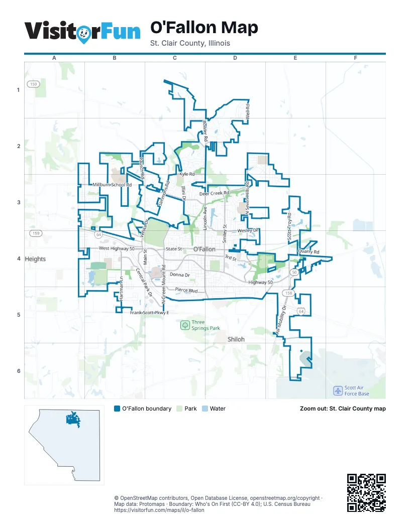
Street index of O'Fallon
Each street on the sheet and the grid squares it crosses.
- Air Mobility DriveE4, E5
- West Highway 50A4, B4, C4
- North Lincoln AvenueD2, C3, D3, C4
- Highway 50A4, B4, C4, D4, E4
- Scott Troy RoadE3, E4
- West State StreetC4
- South Lincoln AvenueC4, D4, C5, D5
- Frank Scott Parkway EastB5, C5
- North Main StreetE4, D5, E5
- Ofallon Troy RoadD2
- Thouvenot LaneB5
- O'Fallon Troy RoadD2
- Cross StreetD5
- North Green Mount RoadC4, C5
- North Seven Hills RoadD2, D3, D4
- Frontage RoadA3, B3, B4, E4, E5
- Millburn School RoadA3, B3, C3
- Central Park DriveB4, C4, C5
- North Smiley StreetD3, D4
- Hartman LaneB4, B5
- East Wesley DriveC3, D3, D4
- East 3rd StreetD4
- Old Collinsville RoadA3, A4
- Simmons RoadC2, C3
- Pierce BoulevardC5, D5
- Fairwood Hills RoadC3, D3
- Kyle RoadC2, D2
- South 7 Hills RoadD4
- Regency Park DriveB4, C4
- East State StreetC4, D4
- Saint Elizabeth's BoulevardC4
- Pausch RoadB2, B3
- Seibert RoadE6
- East Deer Creek RoadD3
- Venita DriveB3, C3, B4
- Cambridge BoulevardC4
- Obernuefemann RoadC3, C4
- West 3rd StreetC4, D4
- Wherry RoadE5
- Taylor RoadB4
- Deer Creek RoadD3
- South Smiley StreetD4
- Regency ParkC4, C5
- Bethel RoadC2
- Porter RoadC3
- Old Vincennes TrailD4, E4
- Bethel School RoadC2, D2
- Schwaegel RoadC4
- Ashland RoadA4
- O'Fallon Family Sports Park RdC3, C4
- Castle Acres DriveB4
- Shadow Ridge CrossingD3, D4
- Illini DriveC2, C3
- Dartmouth DriveD5
- Kings Ridge BoulevardC1
- South Old State Route 158E5, E6
- Shiloh Valley Twp Line RoadE5
- Rutherford RidgeD1, D2
- Spartan CircleD5
- South Walnut StreetC4, C5
- St Ellen Mine RoadB4
- Mirriam ParkwayB2, B3
- West Washington StreetB4, C4
- Longfellow DriveB2
- Nancy DriveC4, C5
- East 2nd StreetD4
- Aladar DriveC4
- Donna DriveC4
- Saint Nicholas DriveD3
- Wildwood LaneD3
- Elisabeth DriveC3
- Golf Course RoadE6
- West Madison StreetC4
- East Jefferson StreetC4, D4
- Nottinghill DriveD3, E3
- Hearthstone DriveD2
- North Cherry StreetC3, C4
- North Oak StreetC3, C4
- Agnes DriveD4
- Old State Route 158E5
- Stantons LaneC1
- Weil RoadD1
- Thornbury PlaceD2, E2, E3
- South Cherry StreetC4
- Weber RoadD4
- Hodgens Mill LaneC2
- Milburn Estates DriveB3
- Fountain Lakes DriveB5, C5
- Greenfield PlaceC5
- East 1st StreetD4
- Summerlin RidgeC2, D2
- Edgewood DriveD5
- Ponderosa AvenueC5
- Quarry RoadE4
- Matthew DriveD5
- Bethel Ridge Farms BoulevardC1, C2
- South Vine StreetD4
- Treybrooke PlaceE3, E4
- Timber Oak RoadD3
- Main StreetC4
- Reiss RoadD3, D4
- Riviera LaneC2
- East Adams StreetC4, D4
- Long DriveB4
- Whitehall DriveD4, D5
- Princeton DriveD4, D5
- Louella LaneE5
- Arbor Green TrailC3
- Covey LaneD2
- Flagstone Pass DriveB2, C2
- Allenbrook AvenueA3, B3
- East 5th StreetC4, D4
- Fairfield PlaceA5, B5
- South Hilgard StreetD4
- East Washington StreetC4, D4
- Juniper DriveC4
- East 4th StreetC4, D4
- Savannah Hills BoulevardA3, B3
- Stonybrook DriveC3
- Victoria LaneD2
- South Augusta StreetD4
- Schwarz Meadow DriveD3
- Saint Francis WayC4
- Oxford Hill RoadD2, E2
- Shamrock DriveC4, C5
- North Vine StreetD4
- Recplex DriveE4
- West Deer Creek RoadC3, D3
- Richland Park DriveB5
- Bossler LaneC3
- Sturbridge TrailA3, B3
- Lantern Lights CircleD1
- West 2nd StreetC4, D4
- Red Hawk Ridge LaneC3
- Chesapeake Junction LaneA3, B3
- Southview PlazaC4, D4
- Lancaster DriveD2
- Amy DriveC5
- Carnie Knolls DriveC3
- Joy DriveC4
- Bowler RoadD2
- Three RiversB5
- Conrad LaneC3
- Buran RoadD2, E2
- Ravenwood CircleD3, D4
- Bandmour PlaceE4
- Stone Briar DriveA3, B3
- Shallowbrook DriveD3
- Prarie CrossingD3, D4
- Hickory Point DriveC2
- Carol Ann DriveC4
- Lincoln Farm RoadC2
- Macon CourtC3
- Knob Creek LaneC2
- Eagle RidgeC4
- Dustin LaneD4
- Emily DriveD4
- Indian Springs RoadC3, D3
- Fontainebleau DriveD4
- Keck Ridge DriveE3
- Pacific Crossing DriveA3, B3
- Brookside DriveB4
- South Oak StreetC4
- Scheibel LaneE5
- Timber Creek LaneD4, D5
- West Nixon DriveC4
- Tazewell DriveC2, C3
- White Pine AvenueC5, D5
- Dale AvenueC4
- Wellesley DriveD4, D5
- West 4th StreetC4
- Merrifields DriveB3
- Heatherwood DriveC3
- Greystone PlaceE2, E3
- North Penn StreetD4
- Eastgate DriveE4, E5
- Mary Todd LaneC2
- Hawthorne PlaceD4, D5
- Westfield DriveD4
- Stone Hill DriveB5
- Natalyns TraceD1, D2
- Bassett StreetA3, B3
- Schwarz RoadD3
- Jacks BendC1
- Peoria LaneC3
- West 1st StreetC4, D4
- Timber Ridge Trace DriveC2
- Rustic Barn RoadC2
- Brandonwood DriveD3
- West Adams StreetC4
- Ashton Falls DriveC2
- Southview DriveD4
- West 5th StreetC4
- Royal Crest WayB3
- Willowbrook WayB3
- Callaway CourtC2
- Woodleaf DriveD3
- Bridgeway DriveB3
- Booster RoadB4
- Knollhaven TrD2
- Meadowbrook DriveB4
- Seagate DriveB3
- Quail RunD3
- Edward StreetC4
- Tea Olive BoulevardA2, B2
- Auto CourtB4
- Vanderbilt PlaceD4
- Edna DriveD4
- Terrace Green LaneB4
- Misty Valley RoadC4
- Woods WayD4, D5
- Cardiff CourtE2, E3
- Tanglewood TraceD3
- East Belpre DriveD3, D4
- Longmeade DriveD2
- Autumn Pine DriveA4, B4
- Armsleigh PlaceE3
- Indian Creek DriveC4
- Arrow Ridge DriveB4
- Fired Brick DriveD1, D2
- St Ellen DriveB4
- Oak Hill Scool RoadE3
- North Hilgard StreetD4
- Sweetwater LaneE4
- Talon DriveC4
- Park Plaza DriveB4
- Borchers LaneE4
- Meadowlark DriveD3, D4
- Rupel LaneC3
- Janeita CourtE3
- Erics RunE2, E3
- West Jefferson StreetC4
- Colleen DriveC4
- Saint Clair StreetB4, C4
- Shadow Rock CourtD1
- Westminster DriveC4, D4
- Moye School RoadD2
- South Lawn AvenueC4
- Catalpa DriveC3
- Douglas AvenueC4
- Willow DriveC4
- Rebecca DriveD4, D5
- Pepperidge DriveD4
- Granite DriveC4
- Mulberry LaneC4
- White Oak DriveC3
- Woodlake CourtD3, D4
- Bellingham CircleA3, B3
- Center Grove DriveC4
- Engle Creek DriveD3
- Oriole DriveC3
- Wheatfield RoadD4
- Parkview DriveD4
- Glen Hollow DriveC3
- Marigold DriveD2
- North Parc GroveC2
- Shawnee CourtC3
- North Orange StreetD4
- Terracotta PlaceE3
- Thoreau DriveB2
- Torchlight LaneD1
- Westbrook CourtC4
- Gambler Terrace CourtB3, C3
- Montebello LaneC4
- Titan DriveC4
- Cherylwood DriveA4, B4
- West Lakeshore DriveD3
- Chickasaw LaneC3
- Estate DriveD4
- Jamestown RoadD4
- Cottage Hill DriveB4
- Monterey StreetD4
- Braeswood Estates DriveE3
- Corporate CrossingE4
- Highland Estates DriveD3
- Forest Green DriveB4, B5
- North Cedar StreetC4
- River Birch DriveB2, B3, C3
- SaddlewoodC1
- East 7th StreetC4, D4
- Lee DriveD4
- Fieldspring CourtC3
- Carson DriveD4
- Lakepointe Centre DriveE4
- Marbleton CircleE4
- Fairyway Wood DriveA2, A3
- Belt AvenueB4
- Cantwell LaneA5
- South Park StreetD4
- Dickinson DriveB2
- Marilyn DriveC4
- Persimmon DriveC4
- Ambrose DriveA3
- Atlantic StreetB4
- Red Pine AvenueC5
- Park Bridge AvenueB3, B4
- Powell DriveB4
- Hilltop DriveE3
- Nathalie Fay LaneD2
- Pine Ridge CourtA4, B4
Places on the map
- A melia V. Carriel Junior High School
- A Storage Inn - O'Fallon
- Ace Hardware
- At Home
- Auffenberg Ford North
- AutoZone
- Baymont O'Fallon St. Louis Area
- Bella Milano
- Buffalo Wild Wings
- Candlewood Suites
- City of O'Fallon Public Works Office
- Comfort Inn & Suites
- Culver's
- Delores Moye Elementary School
- Edward A Fulton Jr High School
- Fairwood Lake
- Hesse Park
- Historic O'Fallon City Hall
- HSHS Saint Elizabeth's Hospital
- O'Fallon Board of Education
- O'Fallon City Hall
- O'Fallon City Park
- O'Fallon Family Sports Park
- O'Fallon Post Office
- O'Fallon Public Cemetery
- O'Fallon SPorts Park Path
- O'Fallon Sportsplex
- O'Fallon Township High School Milburn Campus
- OTHS Weber Field
- Rock Spring Park Trail
- Rock Springs Park
- Rock Springs Park Prairie #3
- Rock Srings Park Prairie #2
- Sam's Club
- St Ellen Mine Park
- The Storage Center
- Walmart Supercenter
Next to O'Fallon
© OpenStreetMap contributors, Open Database License, openstreetmap.org/copyright · Map data: Protomaps · Boundary: Who's On First (CC-BY 4.0); U.S. Census Bureau















