

Illinois map
Proviso Township map
About 147,156 people live here (Census Bureau, 2024 estimate). The sheet's index lists 300 streets; Roosevelt Road, Harrison Street and Tri-State Tollway cross the most grid squares. Things to do inside the boundary: The Pinball Capital.
Open the map (PDF, US Letter)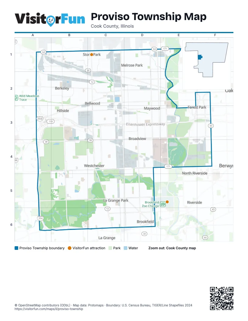
Street index of Proviso Township
Each street on the sheet and the grid squares it crosses.
- Tri-State TollwayA1, A2, A3, A4, A5, A6
- Eisenhower ExpresswayB3, C3, D3, E3, F3
- Ronald Reagan Memorial TollwayA3, B3
- Roosevelt RoadC3, D3, E3, F3, A4, B4, C4
- Cermak RoadB4, C4, D4, E4, F4
- North AvenueB1, C1, D1, E1
- West Lake StreetA1, B1, C1, C2, D2
- South 1st AvenueE2, E3, E4
- Mannheim RoadC2, C3, C4
- East North AvenueA1, B1, C1
- North Mannheim RoadC1, C2
- North La Grange RoadC4, C5, C6
- South Mannheim RoadC4
- South Harlem AvenueF2, F3, F4
- West North AvenueA1, B1
- West Cermak RoadA4, B4, F4
- Ogden AvenueA6, B6
- North 1st AvenueE1, E2
- 1st AvenueE1
- Harlem AvenueF4
- East Lake StreetB1
- West Ogden AvenueB6, C6
- South Railroad AvenueA1
- South La Grange RoadC5, C6
- East Ogden AvenueA6
- Harrison StreetA3, B3, C3, D3, E3, F3, A4
- Madison StreetA3, B3, C3, D3, E3, F3
- Saint Charles RoadA2, B2, C2, D2
- South 25th AvenueC2, C3, C4, D4, D5
- 31st StreetA5, B5, C5, D5
- Washington BoulevardB2, C2, D2, E2, F2
- Butterfield RoadB2, C2, A3, B3
- Des Plaines AvenueE2, F2, E3, F3, E4
- South Wolf RoadB1, B3, B4, B5
- Wolf RoadB2, B5, B6
- Jackson BoulevardB3, E3, F3
- South 5th AvenueD2, D3
- North Wolf RoadB1, B2, B3
- North 25th AvenueC1, C2
- North 5th AvenueD1, D2
- Eastern AvenueC2, C3
- Chicago AvenueA2, D2, E2
- North 17th AvenueD1, D2
- North Frontage RoadB3, C3
- East 31st StreetC5, D5
- Lake StreetD2, E2
- South 21st AvenueD3, D4
- 1st Avenue CutoffE4
- West 31st StreetC5
- South Frontage RoadB3
- East Saint Charles RoadA2
- West Roosevelt RoadF3
- Hillside DriveB3
- Buck RoadA4
- Randolph StreetB2, C2, D2, E2, F2
- Westchester BoulevardC3, C4
- South 9th AvenueD2, D3, D4
- Lexington StreetC3, D3, E3, F3
- Circle AvenueF2, F3, F4
- Washington AvenueA3, B3, D6
- Maple AvenueB3, D5, D6
- 17th AvenueD3, D4, D5
- 9th AvenueD1, D4, D5
- Bellwood AvenueC2, B3, C3
- Prairie AvenueD5, D6
- Kemman AvenueD5, D6
- Bataan DriveD3, E3
- South 17th AvenueD2, D3
- Lathrop AvenueE2, E3, F4
- Grand BoulevardD5, D6
- Hawthorne AvenueC1, E2, C4, C5
- Congress StreetC3, D3, E3
- South Maywood DriveD3
- North 9th AvenueD1, D2
- Brookfield AvenueD6
- North Gilbert AvenueB6
- East Harding AvenueC6, D6
- Brown AvenueE2, F2
- Maybrook DriveE3
- Wedgwood DriveC3
- 16th StreetF4
- Maywood DriveC3, D3
- Beach StreetC3
- Indian Joe DriveC3
- South BoulevardF2
- North Northwest AvenueA1
- Garfield StreetF3
- Van Buren StreetA3, B3, C3, D3, E3
- Division StreetB1, C1, D1, E1, B3
- Sunnyside AvenueB4, B5, C5, D5, D6
- Adams StreetB3, C3, D3, E3, F3
- Harvard StreetA3, C3, D3, E3, F3
- Oak StreetB2, C2, D2, E2
- South 16th AvenueD2, D3, D4
- South 15th AvenueD2, D3, D4
- Broadway AvenueD1, D2, D6
- Fillmore StreetC3, D3, E3, F3
- 22nd AvenueD2, D3, D4
- 24th AvenueC2, C3, D3, D4, D5
- Warren AvenueD2, F2, A3, B3, C3, D3
- Park AvenueA2, E3, E4, D5, D6
- Elgin AvenueF2, F3, F4
- Marengo AvenueF2, F3, F4
- 23rd AvenueD2, D3, D4
- Canterbury StreetB4, C4
- 21st AvenueD2, D3, D4
- Boeger AvenueB4, B5
- South 8th AvenueD2, D3
- South 7th AvenueD2, D3
- South 6th AvenueD2, D3
- 13th StreetC4, D4, E4, F4
- Main StreetC2, D2, E2
- West Le Moyne AvenueC1, D1
- Beach AvenueC5, C6
- Cleveland AvenueD5, D6
- Harrison AvenueD5, D6
- Newberry AvenueC5, C6, D6
- Grant AvenueC2, D2, D6
- Gardner RoadC3, C4
- Wilcox StreetC3, D3, E3
- Mayfair AvenueB4, B5
- East 30th StreetC5, D5
- South 11th AvenueD2, D3
- South 10th AvenueD2, D3
- Augusta StreetD1, E1, C2, D2
- Walton StreetC2, D2, E2
- South 3rd AvenueE2, E3
- South 2nd AvenueE2, E3
- Newcastle AvenueC3, C4
- South 12th AvenueD2, D3
- South 4th AvenueE2, E3
- Homestead RoadC5, C6
- North 15th AvenueD1, D2
- Taft AvenueA2, A3
- Arthur AvenueA2, A3, D5, D6
- South 19th AvenueD2, D3
- Portsmouth AvenueC3, C4
- Linden AvenueC2, C3, B6
- Norfolk AvenueC3, C4
- Barnsdale RoadC5, C6
- Thomas StreetC1, D1
- Proviso DriveB2, C2
- Bristol AvenueC3, C4
- Forest AvenueB3, E4, D5, B6, D6
- Erie StreetB2, C2, D2, E2
- Lincoln AvenueD6
- Forest RoadC5, C6
- Robinhood LaneC5, C6
- Hull AvenueC3, C4
- Manchester AvenueC3, C4
- 18th AvenueD3, D4, D5
- 14th AvenueD3, D4, D5
- Raymond AvenueD5, D6
- 14th StreetC4, D4, F4
- Suffolk AvenueC3, C4
- 11th AvenueD3, D4, D5
- Kensington AvenueB4, B5
- 10th AvenueD3, D4, D5
- Hannah AvenueF3, F4
- Marshall AvenueC2, C3
- West Hirsch AvenueC1, D1
- Morris AvenueB2, C2
- 47th AvenueA1, B2
- 13th AvenueD3, D4, D5
- 12th AvenueD3, D4, D5
- Vernon AvenueD5, D6
- North 22nd AvenueD1, D2
- 19th AvenueD3, D4
- Bohlander AvenueA2, B2
- North 23rd AvenueD1, D2
- North Spring AvenueC5, C6
- North 21st AvenueD1, D2
- Monroe AvenueD6
- Huron StreetA2, B2, D2, E2
- Rice StreetD2, E2
- North 18th AvenueD1, D2
- North 14th AvenueD1, D2
- North 20th AvenueD1, D2
- North 24th AvenueC1, C2
- North Waiola AvenueC5, C6
- South 18th AvenueD2, D3
- South 20th AvenueD2, D3
- Irving AvenueB2, B3
- South 14th AvenueD2, D3
- South 13th AvenueD2, D3
- Railroad AvenueB2, C2, D2
- Downing AvenueB4, B5
- Mandel AvenueB4
- Garfield AvenueC5, D5
- Superior StreetA2, D2, E2
- 15th StreetD4, F4
- West Soffel AvenueB1, C1
- Dickens StreetB4, C4
- Oak AvenueB3, D5, D6
- Monroe StreetC3, E3, F3
- Balmoral AvenueC3, C4
- Buckingham AvenueB4, B5
- Madison AvenueD5, D6
- Blanchan AvenueD5, D6
- Fairview AvenueC6, D6
- Rice AvenueC2, C3
- Windsor DriveB5, C5
- Bohland AvenueC2, C3
- North Park RoadC6
- East 26th StreetC5, D5
- Warren StreetD2, E2
- North 16th AvenueD1, D2
- North 12th AvenueD1, D2
- North Catherine AvenueC5, C6
- Elm AvenueB1, A2, A3, D5, D6
- 23rd StreetC4, D4
- 46th AvenueB1, B2
- Scott DriveD4
- North Stone AvenueC5, C6
- Jackson AvenueD5
- East 29th StreetC5, D5
- Cortez StreetC1, D1
- Haddon StreetC1, D1
- Stratford AvenueC4, C5
- Granville AvenueB2, B3
- 20th AvenueD3, D4
- Community DriveC5, C6
- Ferdinand AvenueF3
- Beloit AvenueF3
- Hyde Park AvenueC2, C3
- Hillside AvenueB1, B2, B3
- 5th AvenueE4
- North Kensington AvenueC5, C6
- Iowa StreetC2, D2
- Sherwood RoadC5, C6
- Geneva AvenueB2, B3
- Greenberg RoadE4, F4
- Miller Meadow-South Access RoadE4
- North Edgewood AvenueC5, C6
- West Hawthorne AvenueA2, B2
- Thomas AvenueF3
- Lind AvenueB1, B2, B3
- Mc Dermott DriveA2, B2
- 51st AvenueB2, B3
- Highridge AvenueB4
- Brainard AvenueC5, C6
- Bemis Woods South Access RoadB6
- Darmstadt RoadA3, B3
- 49th AvenueB2
- 21st StreetC4, D4
- Richmond AvenueC6
- North 11th AvenueD1, D2
- Belleview AvenueC4, C5
- Winston DriveD1
- 48th AvenueB2
- Jackson StreetC3
- Englewood AvenueC2, C3
- West Woodlawn AvenueC6
- Clayton RoadB2, B3
- Frederick AvenueC2
- Electric AvenueA2, B2
- 24th StreetD5
- 34th AvenueC1, C2
- North 33rd AvenueC1, C2
- Oxford StreetB4, C4
- School StreetA2, D3, E3
- 35th AvenueC1
- North 39th AvenueC1, C2
- Victoria AvenueA2
- 40th AvenueC1, C2
- 50th AvenueB2, B3
- 36th AvenueC1
- Chaucer StreetC4
- Kent StreetC4
- Legion StreetD3, E3
- Gladstone StreetC3
- Heidorn AvenueB4
- Kitchener StreetC3
- North 6th AvenueD1, D2
- North 13th AvenueD1, D2
- Enterprise DriveB4, B5
- 43rd AvenueC1
- North 7th AvenueD1, D2
- Howard AvenueA2, B3, B6
- North 8th AvenueD1, D2
- Fencl LaneB3, B4
- North 32nd AvenueC1, C2
- Twining AvenueB2, C2
- Bond StreetC4
- Maple StreetD2, E2
- Pine StreetD2, E2
- Morton AvenueD5, D6
- 37th AvenueC1
- North 2nd AvenueE1, E2
- Orchard AvenueB3, E3, B4
- East 28th StreetC5, D5
- East Hirsch AvenueB1, C1
- Wakefield StreetB5, C5
- North 3rd AvenueE1, E2
- East Oak AvenueC6, D6
- East End AvenueA2, B2, A3, B3
- North 4th AvenueD1, D2
- Southview AvenueD6
- East Morse AvenueB1, C1
- Tripp AvenueD4
Things to do on the Proviso Township map
Places on the map
- 26th Street Woods
- Bataan Park
- Bellwood
- Bemis Woods
- Bemis Woods Preserve
- Berkeley
- Brezina Woods
- Broadview
- Broadview Village Square
- Brookfield
- Brookfield Woods
- Brookfield Woods Preserve
- Chicago Highlands Club
- Concordia Cemetery
- CTA Desplaines Yard
- Edward Hines, Jr. VA Hospital
- Eight Corners
- Forest Home Cemetery
- Forest Park
- Forest Park Plaza
- Fresh Meadow Golf Club
- Glen Oaks Cemetery
- Greenwood Transfer Facility
- Hillside
- Jewish Waldheim Cemeteries
- La Grange Park
- La Grange Park Woods
- Madden Mental Health Center
- Maywood
- Meadowlark Golf Course
- Melrose Park
- Melrose Park Transfer Station
- Miller Meadow
- Miller Meadow Preserve
- Possum Hollow Woods
- Salt Creek
- Salt Creek Woods
- Stone Park
- UP Proviso Yard
- Westchester
Next to Proviso Township
- Berwyn map
- La Grange map
- North Riverside
- River Forest
- Riverside
© OpenStreetMap contributors, Open Database License, openstreetmap.org/copyright · Map data: Protomaps · Boundary: U.S. Census Bureau, TIGER/Line Shapefiles 2024















