

Illinois map
St. Clair Township map
About 35,560 people live here (Census Bureau, 2024 estimate). The sheet's index lists 300 streets; Smelting Works Road, North Illinois Street and North Green Mount Road cross the most grid squares. Things to do inside the boundary: Downstate Illinois.
Open the map (PDF, US Letter)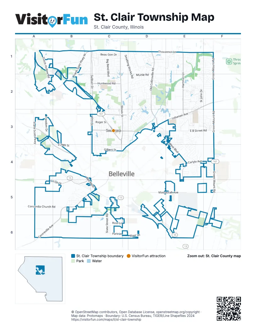
Street index of St. Clair Township
Each street on the sheet and the grid squares it crosses.
- North Illinois StreetC1, C2, C3, C4
- North Belt WestC3
- Carlyle AvenueE4, F4
- Illinois Route 161B2, C3
- North Belt EastC3, D3
- South Illinois StreetC6
- North Green Mount RoadF1, F2, F3, F4
- Centreville AvenueB5, C5, A6, B6
- Lebanon AvenueE2, F2, D3, E3
- Frank Scott Parkway WestB1, C1, B2
- South Belt WestA3, B4, B5, C5
- South Green Mount RoadF4, F5, F6
- Frank Scott Parkway EastC1, D1, E1
- Freeburg AvenueD5, D6
- Mascoutah AvenueD5, E5, F5
- Frank Scott ParkwayA3
- Old Saint Louis RoadA3
- Thouvenot LaneD1, E1
- Old Collinsville RoadD1, D2, D3
- Hartman LaneE1, E2, E3
- West BoulevardD3, E3, E4
- South 11th StreetC4, A5, B5
- Sullivan DriveC1, C2
- Huntwood RoadC2
- Fullerton RoadC3
- Boul AvenueC3
- Morgan StreetC3
- North 17th StreetC3
- Union Hill RoadC1
- South 59th StreetA6
- South 23rd StreetB4
- East Carson DriveA1
- Carson DriveA1
- Smelting Works RoadC1, D1, D2, C3, D3
- Old Caseyville RoadC1, C2, C3
- East B Street RoadE3, F3
- Llewellyn RoadA1, B1, C1
- Caseyville AvenueC3, C4
- Lake Lorraine DriveD2, D3
- Concordia Church RoadA5, B5
- Green Mount LaneE5, E6
- Dutch Hollow RoadA1, A2
- State Street RoadC5, C6
- Kinsella AvenueC3, C4
- Winslow RoadA1, B1
- Cedarwood TrailD1, E1
- Mine Haul RoadA6, B6
- West Waters Edge DriveE1, E2
- Big Bend BoulevardC1, C2
- Saint Sabre DriveC1
- Beau Gon DriveC1
- St John DriveE2
- Williamsburg DriveE3
- Gilbert StreetC4
- Aaron DriveB5
- Lyonshall BoulevardD2
- Freedom DriveA3
- Sundew DriveE3
- Country Meadow LaneE2
- Green Haven DriveC1
- Munie RoadD2
- Lake Christine DriveD2, E2, D3
- Metro WayC3
- Merganser BoulevardD2
- Messinger TrailD2, E2
- Richland Prairie BoulevardE2
- Michael John DriveC1, C2
- Papillon DriveC1
- RavenelD1, E1
- Rand LaneD2
- Brackett StreetC4
- North 15th StreetC3
- Westinghouse DriveE1, F1
- Hidden Lakes DriveD2, E2
- Anderson LaneE3
- Vicksburg DriveE4
- Bunker Hill RoadE4
- Cresthaven DriveE4
- Old Park LaneB1, C1, B2, C2
- Cascade Lake DriveE1, F1
- BivertonD1
- Warrior WayE3
- Avery HillA2
- Pinedale DriveC2, C3
- North 16th StreetC3
- Mary Jo DriveD3
- Ross LaneC6
- Park LaneC6
- Dianne DriveB5
- Hunters WayE3, F3
- Duncan AvenueC3
- Roger StreetC3
- Greystone Estates ParkwayE2, F2
- Belleville Crossing StreetA4, B4
- Cheyenne Wells DriveE2, F2
- Anna StreetC3, D3
- Menard DriveB5
- Glen Mor DriveE2, F2
- Pineywoods DriveC2
- Blanc-Lee DriveC1
- Prairie View RoadE2
- Lake Lucerne DriveE1, F1
- Windrift DriveF4
- Paulette DriveA3
- Lake Inez DriveD3
- Shady LaneE4
- Bourdelais DriveC1
- Penn StreetA2
- San Mateo DriveE3
- Las Olas DriveE3
- East A StreetE4
- McDonald BoulevardC2, D2, C3
- Winthrop DriveE3
- Southwind DriveE3
- Old Freeburg RoadD6, E6
- Liberty DriveA3
- Spruce Hill DriveE3, E4
- Woodfield PlaceD1
- Twin Lake DriveC2
- Mimosa AvenueC1
- Bassen DriveB1, C1
- Oak Grove DriveD3
- Wolf Creek DriveC2
- Lindenleaf LaneC1
- Ganim DriveE2
- Magnolia DriveE4
- Preswyck DriveE1
- Bobbie DriveD3
- Goldenrod LaneC1
- Wood Duck DriveD2
- Bluff Ridge LaneE2, F2
- Tanbark DriveC1, C2
- Carnation DriveE4
- Barrett Lake DriveC2, D2
- Huntleigh DriveB5
- Olroyd DriveD2
- Birmingham DriveE1
- Grimmig RoadC2, D2
- Pasteur LaneD1
- Carrington WayB1, B2
- Lincolnshire BoulevardE4
- East Main StreetE4
- Elizabeth DriveA3
- Haverford DriveE1
- Appaloosa DriveC1, C2
- Cardinal DriveE4
- Cromwell LaneE1
- Van Rue DriveB5
- Coral DriveE4
- Todd LaneE4
- Biver LaneC6, D6
- Redfield DriveD1
- Cedar Mill DriveE3
- Rio Verde DriveE3
- College AvenueF4
- Fox Glenn DriveF3
- Helen StreetC3
- Schilling AvenueD3
- Kimberly Lake DriveD1
- Country View DriveE2
- Old Fullerton RoadC3
- Renoir AvenueD1
- Heitman LaneB1
- Naughton WayB1, C1
- Joyce DriveB2
- Leighigh DriveC2
- East Waters Edge DriveE1, E2
- Britanna DriveD3
- Progress LaneF4
- Greenfield DriveE2
- Oxen DriveE2
- Green Mount TrailF5
- Keil DriveB2
- Mill Spring DriveE4, E5
- Marilyn AvenueC3
- Piper Hills DriveE2, F2
- Turnbridge DriveD3
- Royal Heights RoadB2
- Deer Springs TrailE1
- Ashwood LaneD1, D2
- Tanglebrook DriveE3, F3
- Weatherstone DriveF4
- Janet DriveA3
- Carlyle EastE4
- Sequoia PlaceE1
- Sierra DriveE2, E3
- Coniferous DriveE2
- West Taft StreetC5
- Eastview DriveD3, E3
- Ednick DriveC2
- Village DriveC1
- Deerfield DriveC2
- Roanoke DriveE4
- South 29th StreetA3, B3, B4
- Sumter DriveE4
- Chambers BoulevardD2, D3
- North 2nd StreetC3, C4
- Eastridge DriveF3
- Amann DriveF5
- Timber RidgeC3
- Wendy Way DriveE3
- Sagebrush DriveE3
- El Cerrito DriveE3
- Meridian Lake DriveE1, F1
- Lakeland BoulevardC1
- Chatham DriveE1
- North 66th StreetA2
- High Valley LaneF1
- Pipers CourtE2, F2
- Sandpiper DriveE2
- Bridle LaneC2
- Breckenridge DriveE4
- North 1st StreetC3, C4
- Kimberly Lake LaneD1
- Optimist DriveB5, C5
- Plankway DriveE2
- Crimson View DriveF1
- Hemlock DriveE4
- Simeon DriveE1, F1, F2
- Lauren Lake DriveE1, F1
- Fawnlily DriveE3, E4
- Clairmont DriveE1
- Leland DriveB4, B5
- Rachels WayE1
- Holly DriveB4, E4, B5
- Pensoneau DriveC3, C4
- Fenwood DriveB5
- Potomac DriveE4
- Shade Tree CourtB2, C2
- Kendra Ann DriveC1, C2
- Kingsbury DriveC4
- Thunderbird LaneF4
- Timber DriveD3
- Stonebridge DriveE3, F3
- Woodridge DriveC2, C3
- Whiteside DriveE3
- Ida DriveB2
- Stafford WayB2
- Ambrose Terrace DriveB1
- Bradford PlaceF4
- Adam DriveD3
- Elm DriveA1
- South 16th StreetB4
- Burr OakE3
- Englewood DriveC3
- Ambridge DriveF1, F2
- Brian DriveD3
- Whistling CoveD2
- Bluegrass LaneB5
- Shawn DriveC3
- Oakwood DriveA2
- Creekside DriveD3
- Country RoadE2
- Garden BoulevardE5
- Scottsdale DriveC2
- White Birch LaneD1, E1
- Hampshire LaneE1
- Rosewood Village DriveC2
- Park PlaceC3
- Ramsfield DriveD1
- Crosswinds DriveF3
- Service StreetC3, D3
- Clinton Hill DriveD2
- Timberline DriveB4
- Homestead AvenueC1
- 4th AvenueB4, B5
- Jardin CourtC1
- Flagstone DriveF4
- Cloverridge LaneE3, F3
- Mahogany LaneE1
- Raven Oak DriveE2
- Honeysuckle LaneC2
- Jay AvenueC3
- Kensington Hts RoadA3
- Glenwood DriveC3, D3
- Bernard LaneE3
- Patrick DriveE3
- Banbury PlaceD2
- Maple DriveC6
- Millbrook DriveE3, F3
- Bettina DriveC1
- Narrow Leaf LaneB2
- Westwick CourtC2
- Barrett DriveC2, D2
- Big Oaks LaneB3, B4
- Rose DriveE3
- South Missouri AvenueE5
- Hawkridge RunF2
- Fawn MeadowsD2
- Starlight DriveB4
- Bittersweet LaneE3, E4
- Pawnee DriveC3, C4
- Marla Kay DriveD3
- Melvin Price Memorial City Park DriveC3
- Orchard DriveE4
- Ellington DriveE2
- Fox Creek RoadA1
- Park RoadB6, C6
- Highland DriveA4, B4
- Viburnum DriveC1
Things to do on the St. Clair Township map
Places on the map
- ALDI
- Belle Clair Soccer Park
- Belleville Church of Christ
- Best Royal Inn
- Cambridge House of Swansea
- Catholic Credit Union
- Centenial Park
- CVS Pharmacy
- Dobb's Tire & Auto
- East Side Fire Protection District Station 2
- Gepperts Lake
- Green Mount Catholic Cemetery
- Green Mount Non-Sectarian Cemetery
- Harold Emmerich Airport
- High Mount School
- Holy Shoghagat Armenian Church
- Inez Lake
- Knights of Columbus Council
- Lake Christine
- MedExpress Urgent Care
- Melvin Price Memorial City Park
- Messenger Cemetery
- Motomart
- Northwest Fire Department
- PAK MAIL
- Rider Cemetery
- Rural King
- Saint Constantine and Saint Helen Church
- Schnucks
- Schranz Memorial Park
- St Clair Lake
- Swansea
- Swansea Clinton Hills Conservation Park
- Swansea Volunteer Fire Department
- The Village of Swansea Government Center
- Towerview Baptist Church
- Valhalla Cemetery
- Winchester Plaza
- Wolf Branch Middle School
- Yoch Lake
Next to St. Clair Township
© OpenStreetMap contributors, Open Database License, openstreetmap.org/copyright · Map data: Protomaps · Boundary: U.S. Census Bureau, TIGER/Line Shapefiles 2024















