

Illinois map
Belleville map
About 40,560 people live here (Census Bureau, 2024 estimate). The sheet's index lists 300 streets; West Main Street, West A Street and West Washington Street cross the most grid squares. Also on it: The Orchards Golf Course, Belleville East High School and Belleville West High School.
Open the map (PDF, US Letter)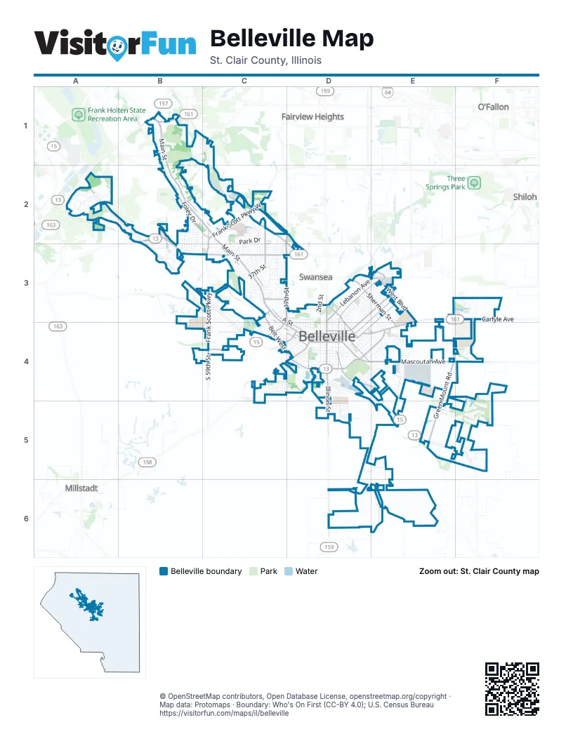
Street index of Belleville
Each street on the sheet and the grid squares it crosses.
- South Illinois StreetD4, D5, D6
- Carlyle AvenueE3, F3, D4, E4
- Illinois Route 161C2, D3
- Sherman StreetD3, E3, E4
- North Illinois StreetD3, D4
- North Belt EastD3
- South New Missouri AvenueA2
- Illinois StreetD4
- West Main StreetB1, B2, C2, C3, C4, D4
- Old Saint Louis RoadA2, B2, B3
- Mascoutah AvenueD4, E4, F4
- North Belt WestB3, C3, D3
- South Green Mount RoadE4, E5
- West A StreetB2, C2, C3, D3, D4
- Lebanon AvenueD3, E3
- South Belt WestC3, C4, D4
- Frank Scott ParkwayC2, C3, C4
- East Main StreetE3, D4, E4
- Frank Scott Parkway WestC2
- East A StreetE3, D4
- West Washington StreetB2, C2, C3, C4, D4
- Freeburg AvenueD4, E4
- South Belt EastD4
- Centreville AvenueC4, D4
- Forest AvenueD4
- Lebanon RoadB1
- East Washington StreetD4
- South 6th StreetD4
- North Oak StreetD4
- North 88th StreetB1
- North Green Mount RoadE3
- East B StreetD3, E3, D4
- North 17th StreetC2, C3, C4
- North Charles StreetD3, E3, D4
- Foley DriveB2, C2
- South 11th StreetC4, D4
- West BoulevardE3, E4
- North Douglas AvenueD3, D4
- McClintock AvenueD4, E4
- Royal Heights RoadC2, C3
- West Lincoln StreetD4
- South 74th StreetB2, B3
- South Charles StreetD4
- North 37th StreetC3
- South 59th StreetC2, C4
- Town Hall RoadB3, C3
- North 28th StreetC3
- South 17th StreetC4
- Old Collinsville RoadE3
- East Lincoln StreetD4
- South 23rd StreetC3
- Sullivan DriveC2, D2
- North 74th StreetB2
- South 95th StreetB1
- East Carson DriveC2
- Signal Hill PlaceB1
- Belleville Crossing StreetC3, C4
- Dutch Hollow RoadB1, C1, C2
- Obstweg DriveE5, D6, E6
- Golf Course DriveE5, F5
- North Church StreetD3, E3, D4
- East C StreetD3, E3, D4
- East McKinley StreetD4, E4
- East D StreetD3, E3, D4
- South Demazenod DriveA2
- Wabash AvenueD4, E4
- North 39th StreetC2, C3
- South Church StreetD4
- Lake Forest DriveC4, D4
- Schluetter Germaine RoadD6, E6
- Scheel StreetD3, E3, D4
- West C StreetB2, C2, D4
- Community DriveA2
- Pro Tour DriveF5
- Reunion BoulevardD5
- East Adams StreetD4
- West Monroe StreetD4
- South Virginia AvenueD4, E4
- Lucinda AvenueD3, E3, E4
- Arapaho DriveC4
- South Pennsylvania AvenueD4, E4
- South 44th StreetC3
- Springdale DriveB2, B3, C3
- Southgate DriveB2, C2
- Old Freeburg RoadE5, E6
- East Monroe StreetD4
- Fairway DriveF4, F5
- North Park DriveC2
- Belleville West ParkwayC3, C4
- North 40th StreetC2, C3
- North Delaware StreetD3, E3
- South High StreetD4
- South Jackson StreetD4
- Union AvenueC4, D4
- Muren BoulevardD3, E3
- State StreetD4
- Green Mount LaneE4
- South 20th StreetC3, C4
- Orchard Lakes CircleE5
- Lasalle StreetD3, E3
- East Belle AvenueD3, E3
- Portland AvenueD4, E4
- Sheridan AvenueC3
- South 2nd StreetD4
- Garden BoulevardE4
- Highwood DriveC1, C2
- North 2nd StreetD3, D4
- Commons ParkwayF3
- Roan Hill CircleF5
- West F StreetC3, D3
- South Missouri AvenueD4, E4
- West B StreetB2, C2, D4
- Foster DriveC3
- West Adams StreetC4, D4
- North 38th StreetC2, C3
- West E StreetC3, D3, D4
- South Park DriveC2, C3
- Orchard DriveE3, E4
- South Douglas AvenueD4, E4
- Biver LaneD5
- North 1st StreetD3, D4
- Clearview DriveB2, C2
- West D StreetD4
- South 3rd StreetD4
- Longview DriveB2, B3
- Sheraton DriveB2, B3
- South 19th StreetC3, C4
- North 5th StreetD3, D4
- Amann DriveE4
- Brookmeadow DriveF4
- East Grant StreetD4
- Springwood DriveC4
- Premier DriveE4
- North 6th StreetD3, D4
- North 41st StreetC2, C3
- North 44th StreetC2, C3
- Carlyle Plaza DriveE4
- Hillwood DriveB1, C1
- South 18th StreetC3, C4
- South 1st StreetD4
- Arthur StreetB1, D3
- West Cleveland AvenueD4
- Kansas AvenueD3, E3
- Hecker StreetD3
- Brittany LaneB2, B3
- East Garfield StreetD4
- Persimmon Ridge RoadC2
- Cedar Grove DriveF3
- Prairie AvenueD4, E4
- Summers TraceC4
- Sedona CircleF5
- Coyote RunF3
- Tenth Fairway DriveF5
- North 3rd StreetD3, D4
- South 10th StreetD4
- North 43rd StreetC2, C3
- Memorial DriveC2
- Raab AvenueC4
- Westfield Plaza DriveB3
- South 29th StreetC3
- Dewey StreetD3, E3
- Turkey Hill LaneE5, F5
- Blue Ridge DriveB2, C2
- South 16th StreetC4
- Granvue DriveB1
- Vicksburg DriveE4
- South 7th StreetD4
- Bellevue Park DriveC2, C3
- North Virginia AvenueD3, D4
- Schilling AvenueE3
- North Pennsylvania AvenueD3, D4
- Summit AvenueC3
- Dapron DriveC2
- Shrine CircleA2
- South 8th StreetD4
- Westhaven School RoadD5
- Park AvenueD4
- South 21st StreetC3, C4
- North Jackson StreetD3, D4
- Denvershire DriveE4
- Stations WayA2
- Jefferson RoadF5
- Mc Kinley DriveE4
- Periwinkle CircleD4, E4
- Industrial DriveE4
- Gettysburg RoadC2
- North High StreetD3, D4
- Stevens StreetC3
- Dublin BoulevardE3
- Bel Aire DriveD4, E4
- Dale Allen DriveC3
- Mount Pleasant LaneC2
- West Harrison StreetD4
- Maple Hill LaneF5
- Vernier AvenueC3
- Chevy Chase DriveB2, B3
- Friendly DriveC3
- East Van Buren StreetD4
- West Belle StreetC3
- Meadowlark LaneC4
- Mitchell LaneB2
- Empire DriveE4
- West H StreetC3, D3
- South 13th StreetC4, D4
- Benton StreetD3
- Columbus DriveC3
- Abend StreetD4
- Rock Hill DriveF5
- South 14th StreetC4, D4
- Magna RoadB3
- Green Mount Commons DriveE3, F3
- Glenview DriveB1
- Florida AvenueD3, E4
- North Water Works DriveB3
- Arabelle DriveD4, E4
- Rosewood DriveB2, B3
- Kretschmer AvenueD3, D4
- Cool Valley DriveE4
- North Michigan AvenueD3, E4
- North Demazenod DriveA2
- North 8th StreetD3, D4
- Country Club AcresB2
- Bristow StreetD3
- Walnut StreetD3, D4
- Brentmoor DriveB3, C3
- Celebration Park CircleD5
- Sycamore StreetD3, D4
- Tower PlazaE4
- North 16th StreetC3, D3, C4, D4
- Clearwater DriveD4
- North 45th StreetC3
- Olive StreetD4
- Oak Knoll PlaceB2
- High Forest DriveC2
- Fort Henry RoadE4
- Westfield Plaza ParkwayB3
- North 36th StreetC3
- North 4th StreetD3, D4
- North 49th StreetC2, C3
- Juanita PlaceB2
- North 42nd StreetC3
- South 52nd StreetC3
- Oak LaneB1, C3
- Roland AvenueC3
- River Laurel DriveD5
- South 27th StreetC3
- North 98th StreetB1
- Page AvenueD3, E3
- Chaucer DriveC2, C3
- Franklin AvenueC4
- Sandwedge DriveD4
- Reserve Walk WayD5
- North 9th StreetD3, D4
- Allsup PlaceB3
- South 22nd StreetC3, C4
- Lake Shore DriveD4
- Jack Nicklaus DriveF4
- North 10th StreetD3, D4
- North Missouri AvenueD3, D4
- Marlo DriveC3
- Church Circle DriveA2
- Walter StreetC3
- Belleville Station LoopD3
- Shirley DriveC2
- Old Caseyville RoadD3
- Saint Clair AvenueD4
- North 11th StreetD3, D4
- Jay AvenueC3
- Highview LaneB1, C1
- South 15th StreetC4, D4
- West Van Buren StreetD4
- Ruck DriveC2
- Queensway DriveC3
- Forest Hills DriveD3
- Laurette LaneC3
- Comwest ParkwayB3
- West J StreetC3, D3
- Freemont StreetD3, E3
- North 66th StreetB2, C2
- Roosevelt AvenueC4
- Flintwood Farm LaneE5
- Autumn Harvest DriveF3
- Woodsong WayD5
- Dawn DriveE4
- Rose Marie DriveD4
- North 48th StreetC3
- Beth Ann DriveE3, E4
- Brookrun DriveF4
- Alexander StreetC3
- Tamaroa LaneC2
- 3 Wood DriveD4
- White StreetD3
- Pheasantwood DriveC2
- Canterbury DriveC3
- Dalton DriveC2
- Westhaven Medows DriveD4
- Green Mount TrailE4
- Canyon Creek DriveF5
- South 47th StreetC3
- North 12th StreetD3, D4
Places on the map
- Ace Hardware
- Associated Bank
- AutoZone
- B'Nai Israel Cemetery
- Beast Craft BBQ Company
- Belle Valley School
- Belle-Clair Speedway
- Belleville City Hall
- Belleville East High School
- Belleville Fire Department Station 1
- Belleville Fire Department Station 2
- Belleville Public LIbrary West Branch
- Belleville West High School
- Bellevue Park
- Ben Emge Airport
- Bicentennial Park
- Bicentennial Park Walking Trail
- Citizen's Park
- Douglas Elementary School
- Dutch Hollow Post Office
- East End Park
- Family Sportsplex
- Green Mount Commons
- Jefferson Elementary School
- Laderman Park
- Memorial Hospital in Belleville
- Mount Carmel Cemetery
- Mount Hope Cemetery
- North End Park
- Pleasant Hill Park
- Signal Hill Athletic Park
- Skyview Drive-In Theater
- South Side Park
- Southwestern Illinois College Prairie
- Stolberg Lake
- The Orchards Golf Course
- Turkey Hill Lake
- Walmart Supercenter
- Walnut Hill Cemetery
- Zion Lutheran School
Next to Belleville
© OpenStreetMap contributors, Open Database License, openstreetmap.org/copyright · Map data: Protomaps · Boundary: Who's On First (CC-BY 4.0); U.S. Census Bureau















