

Indiana map
Fishers map
About 103,986 people live here (Census Bureau, 2024 estimate). The sheet's index lists 300 streets; East 96th Street, East 116th Street and Allisonville Road cross the most grid squares. Things to do inside the boundary: Conner Prairie.
Open the map (PDF, US Letter)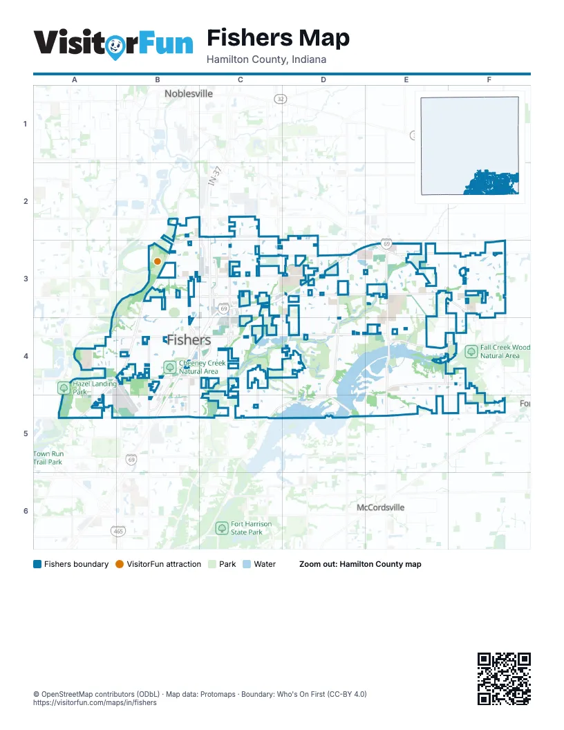
Street index of Fishers
Each street on the sheet and the grid squares it crosses.
- IN-37C3, B4, C4
- East 116th StreetA4, B4, C4, D4, E4
- Allisonville RoadB2, B3, A4, B4, A5
- East 96th StreetA5, B5, C5, D5, E5, F5
- Olio RoadE3, E4, E5
- Southeastern ParkwayE3, F3
- Fall Creek RoadC5, D5
- East 146th StreetB2
- North 600 WestE5
- East 126th StreetB3, C3, D3, E3, F3
- East 106th StreetA4, B4, C4, D4
- Cumberland RoadC2, C3, C4, C5
- Brooks School RoadD3, D4, D5
- Promise RoadC2, C3
- Carroll RoadD5
- East 131st StreetB3, C3, D3, E3
- East 136th StreetC3, D3, E3, F3
- Lantern RoadB3, B4, B5
- Cyntheanne RoadF3, F4, F5
- USA ParkwayB4, C4
- East 141st StreetB2, C2, D2, B3
- Hague RoadB4, B5
- East 104th StreetE4, F4
- Howe RoadC2, C3
- Parkside DriveC3
- 113th StreetE4, F4
- Florida RoadE3, E4, F4
- Hoosier RoadD3, D4
- East 121st StreetC3, D3
- Eller RoadA4, A5
- Atlantic RoadF3
- Crosspoint BoulevardB4, B5
- Britton Park RoadC2, C3
- Mollenkopf RoadC4, C5
- Marilyn RoadD2, D3
- Geist RoadD4, D5
- Georgia RoadE4, E5
- Corydon DriveE3, F3
- Commercial DriveB4
- Masters RoadA5, B5
- Overlook DriveC4
- West 800 SouthF3
- Connecticut AvenueF4
- 135th StreetC3
- Corporation DriveB5
- Herriman BoulevardC2
- Hawthorn RidgeD4
- Windermere BoulevardC4, D4, C5
- Del Webb ParkwayF3
- Hamilton PassC4, D4
- Harrison ParkwayB2, B3
- North by Northeast BoulevardB5
- Gray Eagle DriveD3, E3, D4, E4
- Kincaid DriveB4, B5
- Sunblest BoulevardB3, B4
- Springstone RoadE4, D5, E5
- Duval DriveD3, E3
- Conner Knoll ParkwayB2, B3
- Avalon BoulevardE3
- Knightsbridge LaneC4
- River Glen DriveB4
- Bradwell PlaceB4, B5
- Breakwater DriveD4
- River Place DriveA5
- Geist Ridge DriveE4
- Exit 5 ParkwayC3, C4
- Remington DriveF3
- Municipal DriveB4
- Sweet Briar ParkwayC3
- Ranford BoulevardF4, F5
- IKEA WayC4
- Water Crest DriveC3
- Willow View RoadA4, A5
- Regency DriveB3, B4
- Ellipse ParkwayB3, B4
- Jaywick DriveB4
- Wedgeport LaneD4
- Covington BoulevardB5, C5
- Royalwood DriveE3, E4
- Victory LaneB5
- Fishers Pointe BoulevardB4
- Waterway BoulevardE4
- Royalty DriveE3
- Heatherfield DriveC2, C3
- Harbor Bay DriveE4
- Minden DriveE3
- Woods Edge DriveC4, C5
- Niagara DriveC4
- Greenway DriveC5
- Pennington RoadE3
- Valleyview DriveA4
- Meadow Lake DriveC2, C3
- Girvan WayF3
- Muirfield TraceC4, D4, D5
- Parkway DriveC4, C5
- Technology LaneB4, C4
- Garrick StreetB4
- Formula WayB5
- Orchard BoulevardB3
- Easy StreetA4, B4
- Bridgewater RoadD5
- Silverstone DriveE3
- Orange Blossom TrailC2
- Hamilton Commons BoulevardD3, E3
- Parkshore DriveC3
- Manchester DriveA4
- Sunblest Boulevard SouthB4
- Lakeland DriveC5
- Whitebridge DriveD4
- Tidecrest DriveF3
- Gallop LaneE4, E5
- Wilderness TrailA4, B4
- Hamble BoulevardD4
- Beardsley WayD3
- East 101st StreetF4
- Midnight Line DriveF4, F5
- Great Blue TraceD4
- Kittery DriveD3, D4
- Gilmour DriveF3
- Sawgrass DriveC4
- Whelchel DriveE3, F3
- Chapelwood LaneE3, E4
- Prairie Baptist RoadE3
- Glen Abbey LaneC4, C5
- Roy Anderson BoulevardC2, C3
- Fishers Crossing DriveB4
- Copper Mines WayD3
- Old Oak DriveC2, C3
- Cedar DriveC3, C4
- Raiders BoulevardD3
- Colbarn DriveB3, B4
- Tremont DriveC4
- Brooks CrossingD4
- Nottingham RoadB3
- Hearthstone DriveD4
- Pine Bluff DriveC4
- Haven Cove LaneE4
- Forest Glade DriveE3, F3
- Creektree LaneC3
- Gatwick View DriveE3, E4
- Cobblestone DriveD3, D4
- Brixton LaneC4
- Clarkson WayF3
- Holland DriveB4
- Madden DriveB4
- Eddington PlaceE3
- Treyburn DriveC4, D4
- Avalon East DriveE3
- Sedalia DriveF5
- Plantana BoulevardC2, C3
- Fawnsbrook DriveB3
- Stratford WayA4
- Thames DriveE3
- Forest Knoll LaneD4, E4
- Belle Plaine BoulevardC4, D4
- Brightwater DriveC2, C3
- Catalina DriveD2, D3
- Fishers Station DriveB4
- Providence DriveB2
- Weathered Edge DriveD3
- Westmoreland DriveD3
- Alston DriveE3
- Sand Creek BoulevardC4
- Newburyport DriveE4
- Logan LaneB5, C5
- Anchorage WayD4
- Conner Creek DriveB4
- Club ChaseD4
- Boothbay LaneD3, D4
- Tiger DriveC3, D3
- Woodstock WayB5, C5
- Westpoint DriveB4, B5
- Refreshing Garden LaneC2
- Governors LaneD4
- Talblick StreetD3, E3
- Edgebrook DriveE4, E5
- Bent Grass LaneC3
- Courage CrossingD3
- Copper Saddle BendE4, E5
- Wading Crane AvenueE5
- Rainbow Falls LaneC4
- Castlestone DriveD3
- Franks WayE4
- Idlewood DriveD4
- Ridge DriveC4, C5
- Club Point DriveD4
- East 138th StreetE3
- Sunrise CircleB3, B4
- Cabri LaneD3, D4
- Cherry Blossom East DriveA4, B4
- Woodlands DriveC5
- Apalachian WayD4
- Ardennes DriveB3
- Haywood StreetF3
- Oakleaf WayE5
- Pleasant View LaneC3
- Silverado DriveD4
- Muir LaneC4
- Carriage Stone DriveD3
- Trailwood DriveC3
- Ayshire DriveF3
- Landwood DriveE3, E4
- Buffett ParkwayB3
- Schoolhouse RoadC3, D3
- Chestnut Hill CircleD4
- River Highlands DriveB3
- Whispering Breeze DriveE3
- Shasta DriveC3
- Washington Bay DriveC4
- Highland Springs Drive NorthE5
- Princewood DriveE3, E4
- Blue Ribbon BoulevardE4, E5
- Stable Stone TerraceE5
- USA DriveB4, C4
- Edgefield DriveD4
- Guy StreetD3
- Backstretch RowE4, E5
- Cullerton WayD3
- Fishers Landing DriveB4
- East 134th StreetE3
- Thistle RidgeB4
- Bellingham BoulevardE3
- Charleston ParkwayB4
- Melrose CircleC3
- Meadow Ridge DriveB4
- Coastal PlaceF3
- Gulfstream DriveD4, D5
- Ensley DriveB3
- Oak Haven DriveE4, E5
- Deer Bank RoadF3
- Midnight PassC4
- Suncatcher DriveD4
- Talon TraceD4
- Mancroft DriveE3
- Brook Park BoulevardE4
- Parkview LaneB3, B4
- Dekoven DriveD3, E3
- White River Park DriveA5
- Blooming Orchard DriveC3
- Summerlin WayD4
- Fishers Corner BoulevardB4, C4
- All American RoadD3
- Ford DriveC3
- Tufton StreetB4
- Shoe Overlook DriveB3
- Riverside WayA4, B4
- Overview DriveE3
- Prominence PlaceF4
- Brook Wood DriveE5
- Glass Chimney LaneB5, C5
- Lowery WayF3
- Sea Star WayD4
- South StreetB4
- Weeping Cherry DriveC2
- Brooks Edge CircleE5
- Springtide LaneF3, F4
- Fortune DriveC4
- Paddington ParkwayE3
- Aubrey LaneF4
- Oxbridge PlaceE3
- Slate Stone DriveC4
- Courtyard WayB4
- Black Hills DriveD3
- Malta WayF3
- Memorial WayF3
- Van Buren PlaceD3
- Sweet Creek TrailC3
- Longleaf LaneC3
- Ambergate DriveD3, E3
- Fairwood DriveE5
- Wolverton WayE3
- Bristlecone DriveA4
- Spyglass Ridge DriveC4
- Water Ridge DriveD5
- Ashwood DriveC3
- Gatewood LaneA4, B4
- Twyckenham DriveE3
- Eastpark Circle WestF3
- River Valley DriveD3
- Brookfield DriveE4
- Club PointD4
- Republic DriveD3
- Thorpe Creek ParkwayE3
- Traverse PlaceB3
- Thorny Ridge TraceD4
- Geist View DriveE4
- Fallingbrook DriveA4
- Cherry Blossom West DriveA4
- Fantina LaneE4, F4, E5
- Faucet LaneE4
- Farrington WayE3
- Northhampton DriveB4
- Trophy DriveB3
- Heatherwood DriveE4
- Meadows DriveB4
- Provincal LaneF4
- Lake Ridge LaneD4, E4
- Quarterback LaneD3
- Soaring Eagle LaneE5
- St Andrews WayC3
Things to do on the Fishers map
Places on the map
- 1836 Prairietown
- 1863 Civil War Journey
- Ascension St. Vincent Fishers
- Billericay Park
- Brooks School Park
- Camp Mudsock
- Cheeney Creek Natural Area
- Citizens Reservoir
- Conner Prairie Museum
- Crossing at Fishers District
- Cumberland Park
- Cyntheanne Park
- Delaware Park
- Exit 5 Business Park
- Fall Creek Intermediate
- Fall Creek Junior High
- Fishers AgriPark
- Fishers Crossing
- Fishers District
- Fishers Heritage Park at White River
- Fishers High School
- Fishers Junior High School
- Fishers Station
- Fishers White River Park
- Flat Fork Creek Park
- Geist Pavillion
- Geist Reservoir
- Grace Fishers Church
- Gray Eagle Golf Club and Academy
- IKEA Fishers
- Ironwood Golf Club
- IU Health Fishers Hospital
- Medtech Park
- Ritchey Woods Nature Preserve
- River Glen Country Club
- Riverside School
- Sand Creek Overlook
- Sand Creek Schools
- Saxony Lake
- The Hawthorns Golf & Country Club
Next to Fishers
- McCordsville
- Noblesville map
© OpenStreetMap contributors, Open Database License, openstreetmap.org/copyright · Map data: Protomaps · Boundary: Who's On First (CC-BY 4.0); U.S. Census Bureau