

Indiana map
Hamilton County map
About 379,704 people live here (Census Bureau, 2024 estimate). The sheet's index lists 88 streets; Allisonville Road, North Meridian Street and East 96th Street cross the most grid squares. Things to do inside the boundary: Conner Prairie.
Open the map (PDF, US Letter)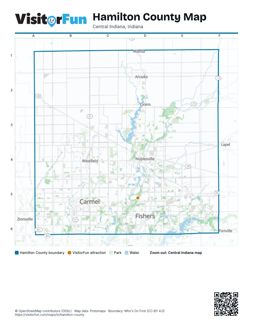
Street index of Hamilton County
Each street on the sheet and the grid squares it crosses.
- Cicero AvenueD1, D2
- Cicero RoadD1, D3, D4
- East 296th StreetE1
- Walnut Grove RoadE1, E2
- East 10th StreetA2, B2
- East 6th StreetA2
- North Sherman StreetA2
- South Main StreetA2
- South Sherman StreetA2
- South White AvenueA2
- State Road 38A2, B3
- West 10th StreetA2
- West 2nd StreetA2
- East 236th StreetB2, C2, D2
- West 236th StreetB2
- East 266th StreetD2, E2, F2
- North Peru StreetD2
- South Peru StreetD2, D3
- West Jackson StreetD2
- Atlantic AvenueF2, F3
- Sheridan AvenueB3, C3, C4, D4
- Allisonville RoadD3, D4, D5, C6, D6
- Carrigan RoadD3
- East 196th StreetD3, D4
- East 206th StreetD3, E3, F3
- Hague RoadD3, D4
- IN-37D3, D4, D5, D6
- Prairie Baptist RoadE3
- Atlantic RoadF3, F4
- West 176th StreetA4, B4
- West Base Line RoadA4
- IN-32B4
- North Meridian StreetB4, C4, B5, C5, B6
- West Main StreetB4, C4, B5, C5
- East Main StreetC4, C5, D5
- Hazel Dell RoadC4, C5
- Little Chicago RoadC4
- Westfield RoadC4, D4
- Cherry Tree RoadD4, C5, D5
- East Conner StreetD4, E4
- Field DriveD4
- Greenfield AvenueD4, D5, E5
- North 10th StreetD4
- Pleasant StreetD4
- River RoadD4, D5
- South 10th StreetD4
- Union Chapel RoadD4, D5, E5
- West Conner StreetD4
- Boden RoadE4, E5
- Fisherburg AvenueE4, F4
- North Pike StreetE4, F4
- Pendleton AvenueE4
- State Road 32F4
- West 146th StreetA5, B5
- East 146th StreetB5, C5, D5, E5
- Old Meridian StreetB5
- Pennsylvania StreetB5, B6
- South Guilford RoadB5, B6
- Towne RoadB5, B6
- US Highway 31 NorthB5
- West 136th StreetB5
- East Greyhound PassC5
- Hazel Dell ParkwayC5, C6
- Keystone ParkwayC5, C6
- North Range Line RoadC5
- South Range Line RoadC5, C6
- Cumberland RoadD5, D6
- East 126th StreetD5, E5
- Brooks School RoadE5, E6
- Campus ParkwayE5
- Olio RoadE5, E6
- Promise RoadE5
- Southeastern ParkwayE5, F5, F6
- Michigan RoadA6
- North Michigan RoadA6
- South Michigan RoadA6
- West 116th StreetA6, B6
- College AvenueB6
- East 111th StreetB6, C6
- East 116th StreetB6, C6, D6, E6
- East 96th StreetB6, C6, D6, E6, F6
- Pennsylvania ParkwayB6
- West 96th StreetB6
- Westfield BoulevardC6
- East 106th StreetD6
- Carroll RoadE6
- Fall Creek RoadE6
- North 600 WestE6
Things to do on the Hamilton County map
Places on the map
- Abbott Commons
- Aberdeen
- Albany Ridge
- Ambleside
- Ambria
- America/Indiana/Indianapolis Timezone
- Anchorage
- Anderson Hall
- Andover
- Andover North
- Arcadia
- Ascension St. Vincent Fishers
- AShfield
- Ashford Place
- Ashmoor
- Ashmore Trace
- Ashton
- Ashwood
- Atlanta
- Autumn Breeze Apartments
- Avalon Springs
- Avalon Townes
- Avian Glen
- Balmoral Village
- Barrington Estates
- Barrington Ridge
- Bayhill
- Beacon Point
- Beaver Pit & Mill
- Bella Vista
- Berkley Grove
- Billericay Park
- Blue Ridge
- Bluestone
- Bonbar at Monon Lake
- Bordeaux
- Bradford Knoll
- Branson Reserve
- Bray Family Homestead Park
- Breakwater
Next to Hamilton County
- Fortville
- Lapel
- Zionsville
© OpenStreetMap contributors (ODbL) · Map data: Protomaps · Boundary: Who's On First (CC-BY 4.0)