

Indiana map
Central Indiana map
The sheet's index lists 14 highways; I-65, I-69 and I-74 cross the most grid squares. Things to do inside the boundary: Anderson Center for the Arts, Benjamin Harrison Presidential Site and Conner Prairie. Also on it: Alexandria, Anderson and Avon.
Open the map (PDF, US Letter)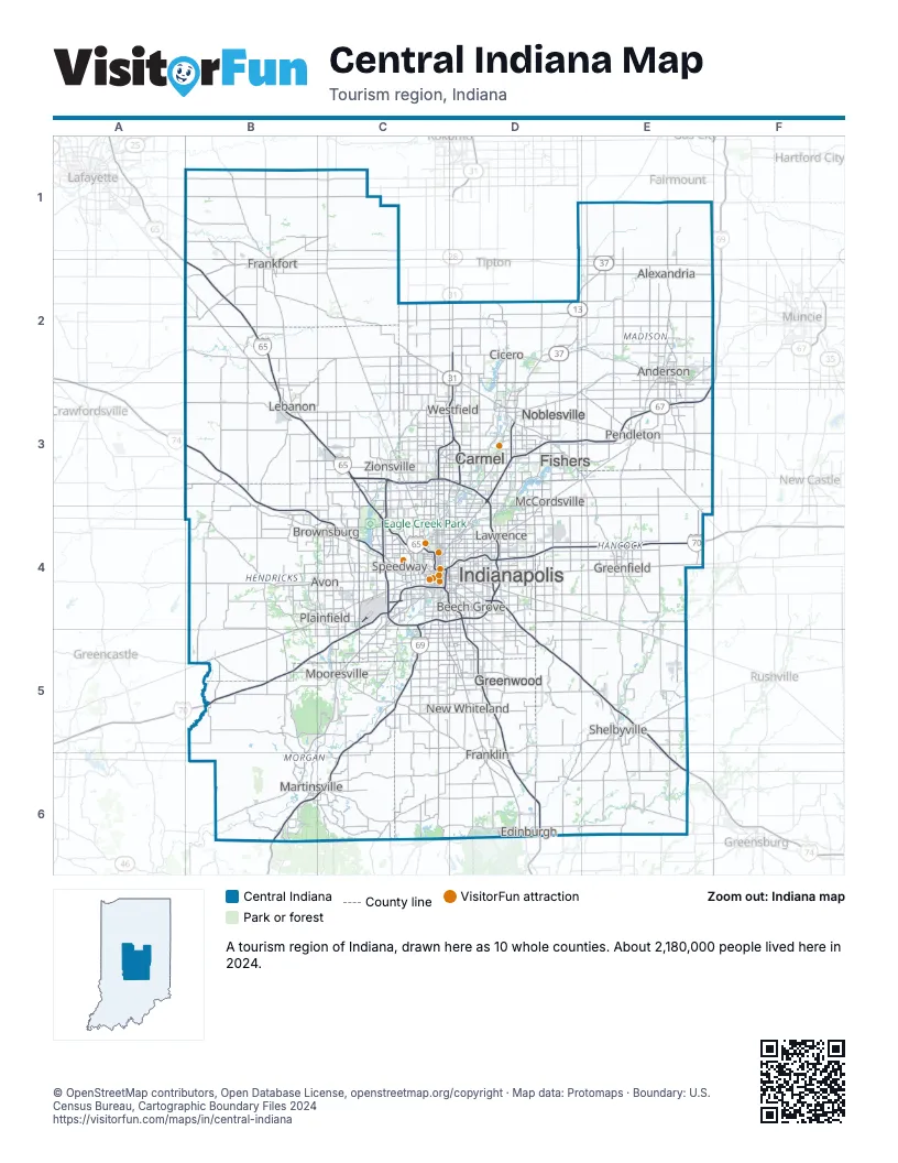
Highway index of Central Indiana
Each highway on the sheet and the grid squares it crosses.
- I-65B2, B3, C3, C4, D4, D5, D6
- I-69B6, C4, C5, C6, D3, D4, E3
- I-70B5, C4, C5, D4, E4
- I-74B3, B4, C4, D4, D5, E5, E6
- I-465C3, C4, D3, D4
- I-865C3
- US 31C3, D2, D3
- US 52B3, C3
- US 421D4, D5, E5, E6
- SR 9E3, E5
- SR 13D2, E2
- SR 37D2, D3, E1, E2
- SR 38E3
- SR 67E3
Things to do on the Central Indiana map
- Anderson Center for the Arts
- Benjamin Harrison Presidential Site
- Conner Prairie
- Eagle Creek Park
- Eiteljorg Museum
- Fort Harrison State Park
- Gainbridge Fieldhouse
- Garfield Park Conservatory and Gardens
- Holliday Park and Nature Center
- Horseshoe Indianapolis
- Indiana Medical History Museum
- Indiana State Museum
- Indiana War Memorial
- Indianapolis Cultural Trail
- Indianapolis Motor Speedway
- Indianapolis Zoo
- James Whitcomb Riley Museum Home
- Kurt Vonnegut Museum and Library
- Mounds State Park
- NCAA Hall of Champions
- Newfields
- Soldiers' and Sailors' Monument
- The Children's Museum of Indianapolis
- Town Run Trail Park
- White River Gardens
Places on the map
- Alexandria
- Anderson
- Avon
- Beech Grove
- Brownsburg
- Carmel
- Cicero
- Edinburgh
- Fishers
- Frankfort
- Franklin
- Greenfield
- Greenwood
- Indianapolis
- Lawrence
- Lebanon
- Martinsville
- McCordsville
- Mooresville
- New Whiteland
- Noblesville
- Pendleton
- Plainfield
- Shelbyville
- Speedway
- Westfield
- Zionsville
Next to Central Indiana
© OpenStreetMap contributors, Open Database License, openstreetmap.org/copyright · Map data: Protomaps · Boundary: U.S. Census Bureau, Cartographic Boundary Files 2024