

Indiana map
Noblesville map
About 75,239 people live here (Census Bureau, 2024 estimate). The sheet's index lists 300 streets; East 146th Street, Allisonville Road and IN-37 cross the most grid squares. Also on it: 21st Amendment Wine and Spirits, Crownland Cemetery and Dr. James A Dillon Park.
Open the map (PDF, US Letter)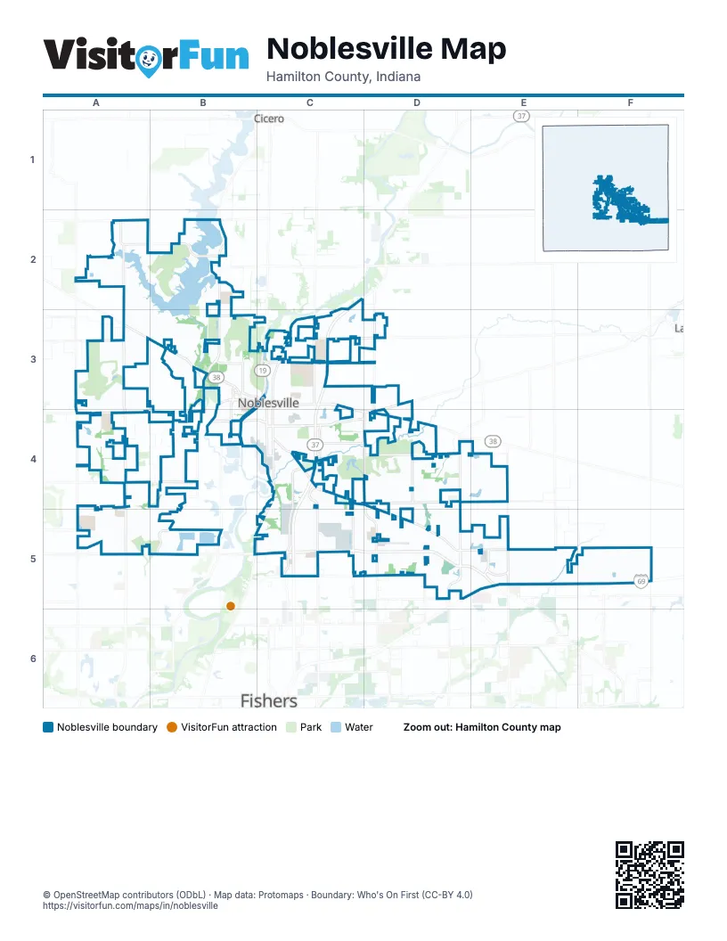
Street index of Noblesville
Each street on the sheet and the grid squares it crosses.
- IN-37C2, C3, C4, C5
- East 146th StreetA5, B5, C5, D5, E5, F5
- Westfield RoadB3, A4, B4
- Sheridan AvenueA3, B3
- Campus ParkwayD5, E5
- East Conner StreetC3, C4, D4
- Cicero RoadB3, C3
- Pendleton AvenueD3, D4
- Fisherburg AvenueD3, D4
- West Conner StreetB3, C3
- Southeastern ParkwayE5
- Pleasant StreetB4, C4, D4
- Little Chicago RoadA2, A3, A4
- Hague RoadB2, B3, B4
- Greenfield AvenueC4, D4, D5
- Hazel Dell RoadA4, A5
- Union Chapel RoadD4, D5
- Boden RoadD4, D5
- Promise RoadD3, D4, D5
- Allisonville RoadC2, C3, C4, B5, C5
- Cherry Tree RoadB4, B5
- River RoadB3, B4, B5
- South 10th StreetC3, C4
- North 10th StreetC3
- East 196th StreetB3, D3
- Carrigan RoadB2
- Field DriveC3
- Hazel Dell ParkwayA5
- Cumberland RoadC3, C4, C5
- East 166th StreetC4, D4, E4
- East 141st StreetC5, D5, E5
- East 156th StreetA4, D4, E4
- East 191st StreetA3, C3, D3
- Herriman BoulevardC4, C5
- Olio RoadE4, E5
- Howe RoadC4, C5
- East 161st StreetA4, B4
- South 8th StreetC3, C4
- Summer RoadD4, D5
- Lakeview DriveB3
- Marilyn RoadD5
- East 186th StreetC3
- Town & Country BoulevardC4, D4
- Tegler DriveD5, E5
- East 211th StreetA2, B2
- Bergen BoulevardE5
- Brooks School RoadD5
- North 16th StreetC3
- Moontown RoadA3, A4
- West Logan StreetB3, C3
- East 216th StreetA2
- Mercantile BoulevardC4
- Prairie Baptist RoadE5
- East Logan StreetC3
- East 136th StreetD5, E5
- East Millcreek RoadA2
- Hamilton County SquareC3
- Carbon StreetC4
- East 169th StreetA4
- Golden Bear WayC4, D4
- North Pointe BoulevardC4, C5
- Oakmont DriveB3, B4
- Buttonwood DriveA2, A3, B3
- Cherry StreetC4
- Midland LaneA5, B5
- North Harbour DriveB2
- Cumberland Pointe BoulevardC4, C5
- Wellington ParkwayC4
- Division StreetB4, C4
- Natasha DriveB4
- South 9th StreetC3, C4
- Prairie Crossing DriveB3
- Maple AvenueC3
- Amber WayC3
- Ashbrook DriveA3
- South 6th StreetC3, C4
- North Mill Creek RoadA3
- Forest Park DriveB3, C3
- Monument StreetC3
- Golden Meadow WayC2, C3
- Hannibal StreetC4
- Dry Creek RoadD4, D5
- Presley DriveC3, C4
- South Harbour DriveB3
- Edgewater DriveB2
- Cabela ParkwayD5, E5
- Oakbay DriveB2
- Cold Stream RoadD5
- Westchester BoulevardB2
- Banbury RoadA2, B2
- North 12th StreetC3
- Cyntheanne RoadF5
- Pine Hill DriveA2
- Timbers ParkwayA2, A3
- Stony Creek WayC4, C5
- Chesterfield DriveC4
- South 16th StreetC3, C4
- Maines Valley DriveA4
- Stones Crossing LaneA3
- Clover RoadC4
- Montview WayA5
- Showdown RoadE4
- Elderberry RoadA2
- South 5th StreetC3, C4
- South 13th StreetC3, C4
- Fawn Hollow LaneD5
- Westbrook BoulevardB4
- Sunset DriveB3
- Mill Grove DriveA3
- East 171st StreetB4
- Wolf Run RoadD4, D5
- Atlantic RoadF5
- Westminster DriveC4, C5
- Harrell ParkwayD5, E5
- Harrison StreetC3
- Roxbury LaneA2, B2
- North 14th StreetC3
- Maple Grove WayA3
- Bluestone DriveA4
- Edenshall LaneA5, B5
- Dakota DriveB2
- Pebble Brook DriveA3
- Stony Creek OverlookC4
- Pebble Brook BoulevardA3, A4
- Mill Oak DriveA3
- Seven Springs LaneD4, E4
- Potters Bridge RoadC3
- North 15th StreetC3
- South StreetC4
- Vine StreetB4, C4
- Fairfield BoulevardC3
- Maraschino DriveB4
- Clinton StreetC3
- Sweetwater DriveA4
- Wayne StreetC3
- Cedar Creek LaneD4
- Redcliff DriveA5
- Edwards Grove DriveA3
- Promenade of Noblesville ParkwayA3, A4
- Plum StreetB4, C4
- Wagon Trail DriveC3
- Citadel DriveA2
- Pine Knoll BoulevardA2
- Windsor LaneC5
- South 11th StreetC4
- Coventry WayA2, B2
- Woodview DriveB3
- East 181st StreetD3
- Promenade Shops BoulevardA3, A4
- Town Center BoulevardE5
- Christian AvenueC4
- Chestnut StreetB4, C4
- Bruce BoulevardA4
- Mundy DriveC5
- Magenta DriveC3
- Grand Cypress DriveC4
- North 9th StreetC3
- Follow DriveD4, D5
- Mahogany DriveA4
- Sommerwood DriveC5
- Wandering WayD4, D5
- Foundation DriveC3
- War Emblem DriveD5
- Hanbury Manor BoulevardD4
- Dunrobin DriveB4, B5
- Hazelnut BoulevardA3
- Rocky Canyon BoulevardE4
- Campus Center DriveD5
- Castle Pine DriveD4
- Sand Brook DriveA3
- Washington StreetB4, C4
- North Banbury RoadA2
- Myers Lake DriveA2
- Queensbury DriveA2, B2
- Wythe DriveB3
- Doverton DriveA2
- Pathway PointeB3
- Valhalla DriveD4
- Bladstone RoadB5
- Wimbly WayC3
- Saw Mill DriveA3
- Ashbourne DriveC5
- Flynn PlaceD4
- Symphony BoulevardC4
- Whisper Ridge DriveD4
- Stonewolf BoulevardD4
- Anderson WayA4
- Castamere DriveA3, A4
- Mulberry StreetC4
- Slateford DriveA5, B5
- Kinder Oak DriveB3
- Hazel Dell CrossingA5
- Cliff OverlookB4
- Catlin LaneA5
- Rushing RiverB3
- Cole Evans DriveC4
- South 19th StreetC3, C4
- Watermead DriveB4
- Cobbs Creek LaneD4
- Fox Chase DriveB3
- Summit RoadA2
- Americana CrossingD4
- Glasgow LaneC4
- Stony Ridge DriveC4
- Fairview ParkwayC3
- North 11th StreetC3
- Lake Station LaneA3
- Yorkshire CircleC4
- Willowview RoadB4
- Seabiscuit DriveD5
- Tradewinds DriveB3
- Heron Trail WayC5
- Dorchester DriveB2
- Redpoll TrailD4
- Douglas Floyd ParkwayC5
- Stoney Creek RoadC4
- Stonebluff LaneA3
- Spayside Drive NorthB5
- Walnut WayA2
- Aegis DriveA2
- Planer DriveA3
- Granite Peak BoulevardE4
- Plains RoadA4
- Old Pond RoadD4, D5
- Longford WayB2
- Lucky Dan DriveD5
- Loch CircleD4
- Harbour Town DriveA2
- Round Lake RoadB3
- Waterhaven DriveA4
- Macduff DriveB5
- Rosebud DriveC5
- SMC BoulevardC5
- Country Lake BoulevardA2
- Lansdowne DriveC4
- Babbling Brook RoadD4
- Hargray DriveA4
- Tenor WayC4
- Drayton DriveA5
- Phillip DriveC3
- Teak DriveA4
- Northface DriveD4
- Pilot Mills DriveA3
- Big Circle DriveB3
- Braemar Avenue EastB5
- Terry Lee CrossingC3, C4
- Oakview DriveB2
- Endeavor DriveC4, C5
- Kensington DriveB5, C5
- Boundary DriveA4
- Willow Pond DriveB4
- Stony LaneD4
- Walnut StreetB4, C4
- Kings LaneC3
- Pegasus DriveD5
- Course View RoadB3
- Evans AvenueC3
- Prairie Lakes Boulevard SouthC5
- Millwood DriveD4
- Burlat LaneB4
- Getz RoadD5, E5
- Piers End DriveB3
- Sandbar DriveB3
- Bladen DriveA4
- Morse Park LaneB2, B3
- North Herriman BoulevardC4
- Taconite DriveD4
- Quicksilver RoadA2
- Kenyon TrailA5
- Windwood ParkwayB3
- Noble Creek DriveC4
- Elmwood CircleB3
- Grant StreetC3
- Ramsey DriveA4, A5
- South 4th StreetB4, C4
- Stockton DriveB3
- Crosscut LaneA3, D3
- Meadow Wood DriveA4
- Unbridled LaneD5
- Winnower DriveD4
- Braemar Avenue NorthB5
- Atkinson DriveC5
- Cerulean DriveC3
- Montfort DriveA5
- Dado DriveA3
- Pebble Brook PlaceA3
- Canal WayC3
- Historic Pleasant StreetB4, C4
- Amberstone LaneC5
- Peach LaneB4
- Village Center DriveA3, A4
- South 7th StreetC4
- Creek Trail DriveA4
- Arbor Grove BoulevardC4
- South 12th StreetC3, C4
- Laurel Crest RunA5
- Searay DriveD3
- Cottage Grove LaneA3
- Stroup DriveA4
- Dunhaven RoadA5
Places on the map
- 21st Amendment Wine and Spirits
- Crownland Cemetery
- Dr. James A Dillon Park
- Finch Creek Park
- Forest Park
- Fox Prairie Golf Course
- Hague Road Nature Haven
- Hamilton County Community Corrections
- Hamilton County Fairgrounds
- Hamilton Town Center
- Hazel Dell Elementary School
- Morse Park
- Noblesville Airport
- Noblesville Creek Shoppes
- Noblesville East Middle School
- Noblesville High School
- Noblesville Post Office
- Noblesville Soccer Fields
- Noblesville Square
- Noblesville West Middle School
- Pebble Brook Golf Club
- Pebble Brook Shops
- Prairie Lakes Health Campus
- Promise Road Elementary School
- Riverplace Center
- Riverview Health Noblesville Hospital
- Roberts-Jacobi Restricted Airport
- Ruoff Home Mortgage Music Center
- St. Theodore Guerin Catholic High School
- Stony Creek Commons
- Stony Creek Elementary School
- Stony Creek Marketplace
- Stonycreek Golf Club
- The Plaza at Saxony Marketplace
- The UPS Store
- Town & Country Shopping Center
- Trinity Sports Park
- Valley Forge Lake
- Walmart Supercenter
- White River Elementary
Next to Noblesville
- Cicero
- Fishers map
© OpenStreetMap contributors, Open Database License, openstreetmap.org/copyright · Map data: Protomaps · Boundary: Who's On First (CC-BY 4.0); U.S. Census Bureau