

Kansas map
Emporia Township map
About 24,354 people live here (Census Bureau, 2024 estimate). The sheet's index lists 74 streets; Road G, Road 140 and Road 150 cross the most grid squares. Also on it: East Lake, ESU Trail and Emporia RV Park.
Open the map (PDF, US Letter)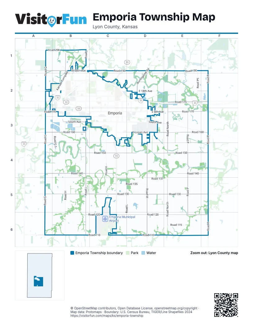
Street index of Emporia Township
Each street on the sheet and the grid squares it crosses.
- Road 190A1, C1, D1, E1
- Road 200A1, B1
- Road GA1, A2, A3, A4, A5, A6
- West 30th AvenueA1, B1
- Crestview DriveB1
- Graphic Arts RoadB1, B2
- Hughes LaneB1
- Kansas TurnpikeB1, A2, B2, A3
- Lakeridge RoadB1
- Road JB1, B3, B4, B5, B6
- Timmerman DriveB1
- Tracy's CrossingB1
- Turnberry Place RoadB1
- Wheatland CourtB1
- Windsor CircleB1
- Derecho CourtC1
- Road KC1, C3, C4, C5
- Burlingame RoadD1, D2
- Road MD1, D2, D4, D5, D6
- Road P5E1, E2
- Road 180A2, E2, F2
- East 18th AvenueD2, E2
- Riley AvenueD2
- Whittier StreetD2
- Bodock RoadE2, F2
- P2 RoadE2
- Road 175E2, F2
- Road NorthE2, E3, E4, E5, E6
- Road North 5E2
- Lakeshore DriveF2
- Locust LaneF2
- Road RF2, F3, F4, F5, F6
- BNSF Spring Switch Access roadA3, B3
- Road 160A3, B3, D3, E3, F3
- Road 170A3, B3, E3, F3
- Freight RoadB3, C3
- Overlander StreetB3
- Prairie StreetB3
- Road G 5B3, B4
- Road HB3, B4, B5, B6
- South Prairie StreetB3
- West South AvenueB3
- 3rd AvenueC3
- Funston StreetC3
- Road 155C3, C4, D4
- Soden RoadC3
- South Commercial StreetC3, C4
- South West StreetC3
- County Road 165D3, E3
- County Road M7D3
- East 6th AvenueD3, E3
- East Logan AvenueD3
- East South AvenueD3
- Morse LaneD3
- Morse RoadD3, D4
- Road M5D3
- Road M7D3
- South Weaver StreetD3, D4
- Wanamaka RoadD3
- Warren WayD3
- Weaver StreetD3
- Road PE3, E4, E5, E6
- Road 167F3
- Road 140A4, B4, C4, D4, E4, F4
- Road 145A4
- Road 150A4, B4, C4, D4, E4, F4
- Road 130A5, B5, C5, D5, E5, F5
- Road 135C5, D5
- Road 137D5, E5
- Road LD5, D6
- Road 110A6, B6, C6, D6
- Road 120B6, C6, D6, E6
- County Road 120E6, F6
- Road 115E6
Places on the map
- BNSF Spring Switch Access road
- Camp Alexander Trail Trailhead
- East Lake
- Emporia RCAG
- Emporia RV Park
- ESU Trail
- Evergreen Cemetery
- Fowler Cemetery
- Fowler School
- Greenwood Cemetery
- Lakeside School
- Mary's Place Airport
- Quaker Valley School
- Rinker School
- Sacred Heart Cemetery
- Sardis Church
- Spring Switch
Next to Emporia Township
© OpenStreetMap contributors, Open Database License, openstreetmap.org/copyright · Map data: Protomaps · Boundary: U.S. Census Bureau, TIGER/Line Shapefiles 2024















