

Kansas map
Topeka map
About 125,467 people live here (Census Bureau, 2024 estimate). The sheet's index lists 300 streets; Southwest 11th Street, Truman/Eisenhower Presidential Highway and Southwest Topeka Boulevard cross the most grid squares. Things to do inside the boundary: Brown v. Board of Education National Historical Park, Kansas Historical Society and Kansas State Capitol.
Open the map (PDF, US Letter)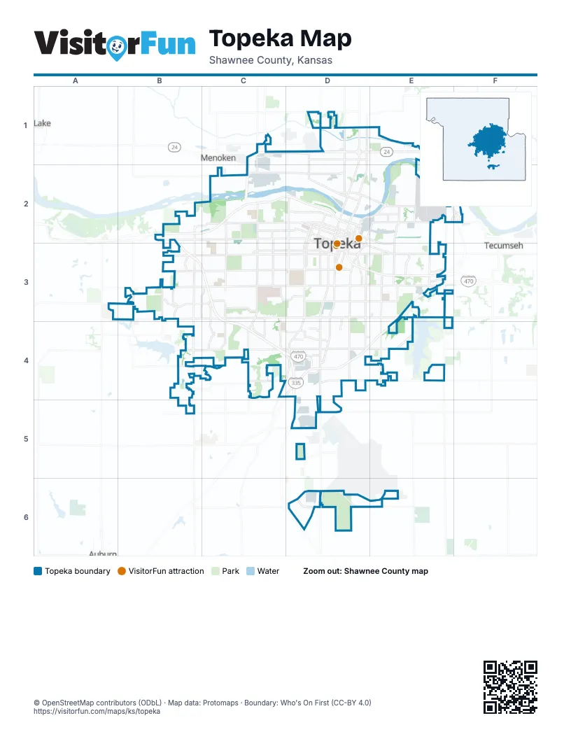
Street index of Topeka
Each street on the sheet and the grid squares it crosses.
- Truman/Eisenhower Presidential HighwayB2, C2, D2, D3, E3
- Dr. Martin Luther King Jr. Memorial HighwayB3, C3, C4, D4
- Kansas TurnpikeE3, D4, E4
- Northwest 24th StreetD1
- Addy Westgate Memorial BridgeC2
- Southwest Topeka BoulevardD2, D3, D4, D5, D6
- Southwest 6th AvenueB2, C2, D2
- Southwest 10th AvenueB2, C2, D2, D3
- Southeast 6th AvenueD2, D3, E3
- Northwest Topeka BoulevardD1, D2
- Southeast Madison StreetD2, D3, D4
- Southeast Monroe StreetD2, D3, D4
- Southeast 10th AvenueD3, E3
- Oakland ExpresswayE2, F2
- Southwest 21st StreetB3, C3, D3
- Southwest 29th StreetB3, C3, D3
- Southeast Adams StreetD2, D3, D4, D6
- Southwest Gage BoulevardC2, C3, C4
- Southeast California AvenueE2, E3, E4, E6
- Southwest 17th StreetB3, C3, D3
- Southwest Wanamaker RoadB2, B3, B4, B5
- Southwest Huntoon StreetB3, C3, D3
- South Kansas AvenueD2, D3, D4
- Southwest Fairlawn RoadC2, C3, C4
- North Kansas AvenueD1, D2
- Southwest Macvicar AvenueD2, D3, D4
- Southeast 21st StreetD3, E3
- Southwest Burlingame RoadD3, C4, D4
- Southwest 37th StreetB4, C4, D4
- Southeast 29th StreetD3, E3
- Southwest 12th StreetB3, C3, D3
- Southwest 8th AvenueC2, D2, D3
- Southeast 45th StreetD4, E4
- Northwest 17th StreetC2, D2
- Northeast Seward AvenueE2, F2
- Southeast Croco RoadE3, E4
- Southwest Washburn AvenueD2, D3
- Southeast 37th StreetD4, E4
- Southwest Lane StreetD2, D3, D4
- Northeast Sardou AvenueD2, E2
- Southwest Harrison StreetD2, D3, D4
- Southwest Seabrook AvenueC3, C4
- Southwest Urish RoadB2, B3
- Northwest Tyler StreetD1, D2
- Northeast Quincy StreetD1, E1, D2, E2
- Northwest Gordon StreetD2
- Northeast Croco RoadE2, F2
- Northeast Strait AvenueE2
- Southwest 42nd StreetC4, D4
- Southwest Jackson StreetD2, D3
- Southwest 45th StreetC4
- Southeast Branner StreetD2, E2, D3
- Northwest Rochester RoadD1
- Northwest Vail AvenueD1, D2
- Southeast 8th AvenueD3, E3
- Southwest Indian Hills RoadB3
- Northwest Morse StreetD2
- Southeast Branner TrafficwayD3
- Northwest MacVicar AvenueD2
- Northeast Gordon StreetD2, E2
- Southwest 57th StreetD5
- Northeast Branner StreetE2
- Northwest 35th StreetD1
- Northeast Morse StreetD2
- Southeast 6th StreetE3
- Southwest 27th StreetA3, B3, C3, D3
- Southwest 25th StreetB3, C3, D3
- Southwest Randolph AvenueC2, C3, C4
- Southwest Belle AvenueC2, C3, C4
- Southwest Oakley AvenueC2, C3, C4
- Southwest 33rd StreetB4, C4, D4
- Southeast Indiana AvenueD3, D4
- Southeast 2nd StreetD2, E2
- Southwest Clay StreetD2, D3
- Northwest Frontage RoadC1, D1
- Southwest Western AvenueD2, D3
- Southeast 25th StreetD3, E3
- Southwest Westport DriveB3, C3, C4
- Southeast Golden AvenueE2, E3, E4
- Southeast Jefferson StreetD2, D3, D4
- Southwest Arrowhead RoadC3, C4
- Southwest 34th StreetC4, D4
- Southeast 4th StreetD2, E2, E3
- Southwest 9th StreetB2, C2, D2, D3
- Southwest Shunga DriveC3, D3
- Southeast Quincy StreetD2, D3, D4
- Southeast 23rd StreetD3, E3
- Southeast Rice RoadE2, E3
- Northwest Lyman RoadD1
- Southwest Arvonia PlaceB3, B4
- Southwest 1st StreetD2
- Southwest Twilight DriveC3, C4
- Southwest 4th StreetB2, C2, D2
- Southeast 77th StreetD6, E6
- Southeast 5th StreetD2, E2, E3
- Southeast Highland AvenueE3, E4
- Southeast Deer Creek TrafficwayE3
- Southwest 14th StreetC3, D3
- Northwest 25th StreetC1, D1
- Northwest Taylor StreetD1, D2
- Southeast Fremont StreetD3, D4
- Northeast Chester AvenueE2
- Southeast Wisconsin AvenueE3, E4
- Southwest 5th StreetC2, D2
- Southwest 32nd StreetB4, C4, D4
- Southwest Innovation ParkwayD6
- Southwest 38th StreetB4, C4, D4
- Southeast Lakeshore BoulevardE4
- Southwest 41st StreetB4, C4, D4
- Southwest 32nd TerraceC4, D4
- Southeast Carnahan AvenueE3
- Southeast Gary Ormsby DriveD6
- Southwest Arnold AvenueC3, C4
- Northeast Jefferson StreetD2, E2
- Southwest Kingsrow RoadB3
- Southwest 39th StreetB4, C4, D4
- Northwest Lower Silver Lake RoadD2
- Northwest Menninger RoadD1
- Southeast 34th StreetD4, E4
- Southeast 1st StreetD2, E2
- Southwest Westchester RoadC2
- Southeast 15th StreetD3
- Southeast Washington StreetD3
- Northeast Division StreetE2
- Southeast 9th StreetD3, E3
- Southeast West Edge RoadE3, E4
- Southwest Croix StreetD4
- Northwest Stover RoadC1
- Southeast 17th StreetD3
- Southwest Westview AvenueD4
- Northeast Freeman AvenueE2
- Southwest Willow AvenueD2
- Northeast River RoadD2, E2
- Southwest Roosevelt StreetD2
- Northwest Brickyard RoadC1, C2
- Southeast Cyprus DriveE3
- Southwest Summit AvenueD2
- Southeast 53rd StreetD5
- Southwest Greenwood AvenueD2
- Southwest Woodlawn AvenueD2
- Southeast Sycamore DriveE3
- Northwest Green Hills RoadD1
- Southwest Clontarf StreetD4
- Northeast Rice RoadE2
- Northeast Golden AvenueE2
- Southwest Martin DriveD4
- Southwest Gary Ormsby DriveD6
- Southwest 53rd StreetB5
- Southwest 10th StreetB2
- Northeast Calhoun Bluff RoadE1
- Southwest Southgate DriveD4
- Northwest Beverly StreetD2
- Northeast Jefferson TrafficwayD2
- Southwest Quinton AvenueD2
- Rice Road, I 170, Cypress Road RoundaboutE3
- Rice Road, I 170, Sycamore Road RoundaboutE3
- Northwest Goodyear RoadD1
- Southwest University BoulevardD5
- Southwest 19th StreetC3, D3
- Southwest Jewell AvenueD2, D3, D4
- Southwest 23rd StreetB3, C3, D3
- Southwest 15th StreetC3, D3
- Southwest 11th StreetB2, C2, D2, B3, C3, D3
- Southwest Plass AvenueD2, D3, D4
- Southwest Fillmore StreetD2, D3, D4
- Southwest 7th StreetC2, D2
- Southwest Buchanan StreetD2, D3
- Southwest 24th StreetB3, C3, D3
- Southwest Moundview DriveC3, C4
- Southwest College AvenueD2, D3, D4
- Southwest Mulvane StreetD2, D3, D4
- Southwest Lincoln StreetD2, D3, D4
- Southwest Van Buren StreetD2, D3, D4
- Southwest 3rd StreetC2, D2
- Southwest 28th StreetB3, C3, D3
- Southwest High AvenueC2, C3
- Southwest 13th StreetC3, D3
- Southwest 22nd ParkB3, C3, D3
- Southwest Wayne AvenueD2, C3, D3, C4
- Southwest 16th StreetC3, D3
- Southwest Munson AvenueC3, D3
- Southeast Michigan AvenueD3, E3, D4, E4
- Southwest 18th StreetC3, D3
- Southeast Minnesota AvenueE3, E4
- Southwest 49th StreetC4, D4
- Southwest Mission AvenueC3, C4
- Southwest 30th StreetC3, C4, D4
- Southwest Cambridge AvenueC2, C3, C4
- Southwest Medford AvenueC2, C3
- Southwest Burnett RoadC3, C4
- Southeast Colorado AvenueE3, E4
- Southwest Lincolnshire RoadB3, B4
- Southwest 20th StreetC3, D3
- Southwest 26th StreetA3, B3, C3, D3
- Southeast Pennsylvania AvenueD3, D4
- Southwest Westridge MallB3
- Southeast Illinois AvenueD3, D4, E4
- Southeast Maryland AvenueD3, D4
- Southeast Ohio AvenueD3, D4
- Southwest Stonybrook DriveB4
- Northeast Grantville RoadE1, E2
- Southwest 29th TerraceC3, D3, D4
- Southwest Tyler StreetD2, D3
- Southeast 28th StreetD3, E3
- Southwest 2nd StreetD2
- Southwest Polk StreetD2, D3
- Southwest Lakeside DriveC3, C4
- Southwest Collins AvenueC2, C3
- Southwest Webster AvenueC2, C3
- Southwest Crest DriveC2, C3, C4
- Southeast 7th StreetD2, D3, E3
- Southwest 31st StreetB4, C4, D4
- Southeast 27th StreetD3, E3
- Southwest Central Park AvenueD3, D4
- Southwest Prairie RoadC2, C3, C4
- Southwest Watson AvenueC2, C3, C4
- Southwest Boswell AvenueD2, D3, D4
- Southwest Eveningside DriveC3, C4
- Southeast 10th StreetE3
- Southeast Massachusetts AvenueD3, D4
- Southeast Kentucky AvenueD3, D4
- Old Highway 24D1, E1
- Southwest Atwood AvenueC3, C4
- Southwest Chelsea DriveC3, C4
- Southwest McAlister AvenueC3
- Northeast Forest AvenueE2
- Southeast 22nd StreetD3, E3
- Southeast 31st StreetD4, E4
- Southeast 43rd TerraceD4, E4
- Southwest Garfield AvenueD2, D3, D4
- Southeast Chandler StreetD2, E2, D3
- Southeast Virginia AvenueD3, D4
- Southwest Indian TrailC3
- Northeast Monroe StreetE1, D2, E2
- Southeast Iowa AvenueE3, E4
- Southwest Meadow LaneC2, C3, C4
- Northeast Oakland AvenueE2
- Southeast 33rd TerraceD4, E4
- Southeast 3rd StreetD2, E2
- Southwest 31st TerraceB4, C4, D4
- Southeast Wittenberg RoadE3
- Southeast 13th StreetD3, E3
- Northeast Madison StreetE1, D2, E2
- Southwest Stone AvenueC3, C4
- Southeast Long StreetE3, E4
- Northwest Polk StreetD1, D2
- Southwest 33rd TerraceC4
- Southeast 26th StreetD3, E3
- Northeast Kellam AvenueE2
- Southwest 23rd TerraceB3, C3
- Southeast 24th StreetD3, E3
- Southwest Glendale DriveC2, C3, C4
- Northeast Winfield AvenueE2
- Northeast Laurent StreetD2, E2
- Northeast State StreetE2
- Southwest 36th StreetB4, C4, D4
- Southwest 35th StreetB4, C4
- Southwest 22nd StreetC3, D3
- Southwest 28th TerraceB3, C3, D3
- Northeast Arter AvenueE2
- Southeast Truman AvenueD4
- Southeast 43rd StreetD4, E4
- Southeast 11th StreetD3, E3
- Access RoadD1, E1
- Southeast 35th StreetD4, E4
- Northeast Wabash AvenueE2
- Northwest Buchanan StreetD1, D2
- Southeast 36th StreetD4, E4
- Southwest Edgewater TerraceC3
- Southwest Frazier AvenueC2, C3
- Northeast Fairchild StreetD2, E2
- Southwest Wenger StreetD4, D5
- Southeast Market StreetE2, E3
- Southwest James StreetC3, C4
- Southwest 35th TerraceC4, D4
- Southwest Taylor StreetD2, D3
- Southwest Pembroke LaneC3
- Southwest 24th TerraceB3, C3
- Southwest Ashworth PlaceB3, C3
- Northwest Central AvenueD1, D2
- Southeast Girard StreetD4
- Southeast 42nd StreetD4, E4
- Southeast 35th TerraceD4, E4
- Southwest Sena DriveC3
- Southeast 12th StreetD3, E3
- Northeast Meriden RoadE1, E2
- Southeast Swygart StreetE2, E3, E4
- Southwest 17th TerraceC3
- Northwest Clay StreetD1, D2
- Southwest Saline StreetC2, C3
- Perimeter RoadD6, E6
- Northeast Grant StreetD2, E2
- Southwest Morningside RoadC2, C3
- Northwest Harrison StreetD2
- Southeast 33rd StreetD4, E4
- Southwest Tara AvenueD4
- Southeast 44th StreetD4, E4
- Northeast Michigan AvenueE2
- Southeast Lawrence StreetE2, E3
- Southwest Westwood DriveC3, C4
Things to do on the Topeka map
Places on the map
- Bauersfelds Market
- Berkshire Country Club
- Big Shunga Park
- Clarion Woods Park
- Colmery-O'Neil VA Medical Center
- Crestview Park
- Cypress Ridge Golf Course
- Dornwood Park
- Fairlawn Plaza
- Felker Park
- Grant Bradbury Park
- Hayden Catholic High School
- Heartland Park
- Hillcrest Park
- Hummer Sports Park
- Kansa Science Education Park
- Kansas National Guard
- Kansas Neurological Institute
- Kansas River MacVicar Wildlife Area
- Kansas State Capitol
- Kaw River State Park
- Kaw Valley Plaza
- MacLennan Park
- Memorial Park Cemetery
- Mount Hope Cemetery
- North Topeka Golf Center
- Oakland Billiard Park
- Philip Billard Municipal Airport
- Potwin Place
- Riverside ATV Park
- Rueger Park
- Security Benefit
- Shawnee Country Club
- Skyline Park
- St. Francis Health Center
- Stormont Vail Events Center
- Stormont Vail Health
- Warren Park
- West Ridge Mall
Next to Topeka
- Auburn
- Menoken
- Tecumseh
© OpenStreetMap contributors, Open Database License, openstreetmap.org/copyright · Map data: Protomaps · Boundary: Who's On First (CC-BY 4.0); U.S. Census Bureau