

Kentucky road map
I-64 in Kentucky map
I-64 is about 187 miles in Kentucky. It has 52 exits, from Exit 1 at mile 0 to Exit 191 at mile 186. It meets 68 highways; US 60, US 150 and US 31W meet it in the most grid squares.
Open the map (PDF, US Letter)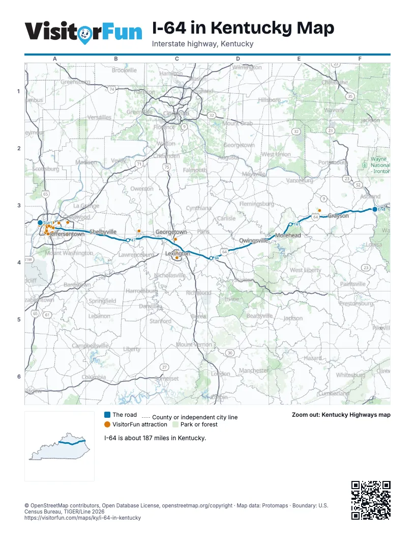
Exits on I-64 in Kentucky
Each exit in mile order, with its grid square.
- Exit 1mile 0, A3
- Exit 0-B/0-Amile 0, A3
- Exit 3mile 2, A3
- Exit 4mile 3, A3
- Exit 5Bmile 4, A3
- Exit 5mile 4, A3
- Exit 137mile 4, A3
- Exit 6mile 5, A3
- Exit 1C/1Bmile 5, A3
- Exit 7mile 5, A3
- Exit 5Amile 5, A3
- Exit 8mile 7, A3
- Exit 10mile 9, A3
- Exit 19Bmile 11, A3
- Exit 12mile 12, A3
- Exit 15mile 13, A3
- Exit 17mile 15, A3
- Exit 19mile 17, A3
- Exit 19Amile 18, A3
- Exit 25Amile 18, A3
- Exit 28mile 27, B3
- Exit 32mile 31, B4
- Exit 35mile 34, B4
- Exit 43mile 42, B4
- Exit 48mile 46, B4
- Exit 53Amile 51, B4
- Exit 53Bmile 52, B4
- Exit 58mile 57, B4
- Exit 65mile 63, C4
- Exit 69mile 68, C4
- Exit 75mile 73, C4
- Exit 118mile 73, C4
- Exit 115mile 75, C4
- Exit 113mile 77, C4
- Exit 111mile 79, C4
- Exit 81mile 80, C4
- Exit 87mile 85, C4
- Exit 94mile 92, C4
- Exit 96mile 94, D4
- Exit 98mile 95, D4
- Exit 101mile 100, D4
- Exit 110mile 107, D4
- Exit 121mile 118, D4
- Exit 123mile 121, D4
- Exit 133mile 131, E4
- Exit 156mile 153, E3
- Exit 161mile 158, E3
- Exit 172mile 168, F3
- Exit 179mile 175, F3
- Exit 181mile 177, F3
- Exit 185mile 182, F3
- Exit 191mile 186, F3
Highways I-64 meets
Each highway it meets and the grid squares where they meet.
- US 150A3
- US 31WA3
- I-65A3
- US 31A3
- I-71A3
- US 60A3, B4, D4, F3
- US 42A3
- KY 1932A3
- I-264A3
- I-265A3
- KY 841A3
- KY 1531A3
- KY 1848B3
- KY 2824B4
- KY 55B4
- KY 2257B4
- KY 2923B4
- KY 53B4
- KY 2558B4
- KY 2826B4
- KY 1790B4
- KY 714B4
- KY 395B4
- KY 2823B4
- KY 1472B4
- KY 151B4
- US 127B4
- KY 1681B4
- US 421C4
- US 62C4
- I-75C4
- US 25C4
- KY 922C4
- KY 353C4
- US 68C4
- US 27C4
- KY 57C4
- KY 859C4
- KY 2072C4
- KY 1678C4
- KY 2888C4
- KY 1958C4
- KY 627D4
- KY 9000D4
- KY 713D4
- US 460D4
- KY 11D4
- KY 36D4
- KY 801E4
- KY 32E3
- KY 799E3
- KY 1662E3
- KY 59E3
- KY 2E3
- KY 1704E3
- KY 1025E3
- KY 182E3
- KY 1947F3
- KY 1959F3
- KY 1F3
- KY 7F3
- KY 1910F3
- KY 207F3
- KY 966F3
- KY 180F3
- KY 538F3
- US 23F3
- KY 3F3
Towns along I-64 in Kentucky
In mile order, with the grid square of each.
- Louisvillemile 0, A3
- Seneca Gardensmile 8, A3
- St. Matthewsmile 9, A3
- Meadowview Estatesmile 11, A3
- St. Regis Parkmile 11, A3
- Norwoodmile 11, A3
- Louisville/Jefferson County metro government (balance)mile 12, A3
- Hurstbournemile 12, A3
- Cambridgemile 12, A3
- Jeffersontownmile 13, A3
- Douglass Hillsmile 15, A3
- Middletownmile 16, A3
- Woodland Hillsmile 16, A3
- Simpsonvillemile 25, B3
- Shelbyvillemile 30, B4
- Frankfortmile 51, B4
- Midwaymile 63, C4
- Lexington-Fayettemile 69, C4
- Winchestermile 92, C4
- Mount Sterlingmile 106, D4
- Owingsvillemile 118, D4
- Moreheadmile 134, E4
- Olive Hillmile 155, E3
- Graysonmile 167, F3
- Cannonsburgmile 181, F3
Things to do on the I-64 in Kentucky map
© OpenStreetMap contributors, Open Database License, openstreetmap.org/copyright · Map data: Protomaps · Boundary: U.S. Census Bureau, TIGER/Line 2026