

Louisiana map
St. James Parish map
About 19,110 people live here (Census Bureau, 2024 estimate). The sheet's index lists 300 streets; Airline Highway, Hymel Street and Helvetia Street cross the most grid squares. Things to do inside the boundary: Laura Plantation and Oak Alley Plantation.
Open the map (PDF, US Letter)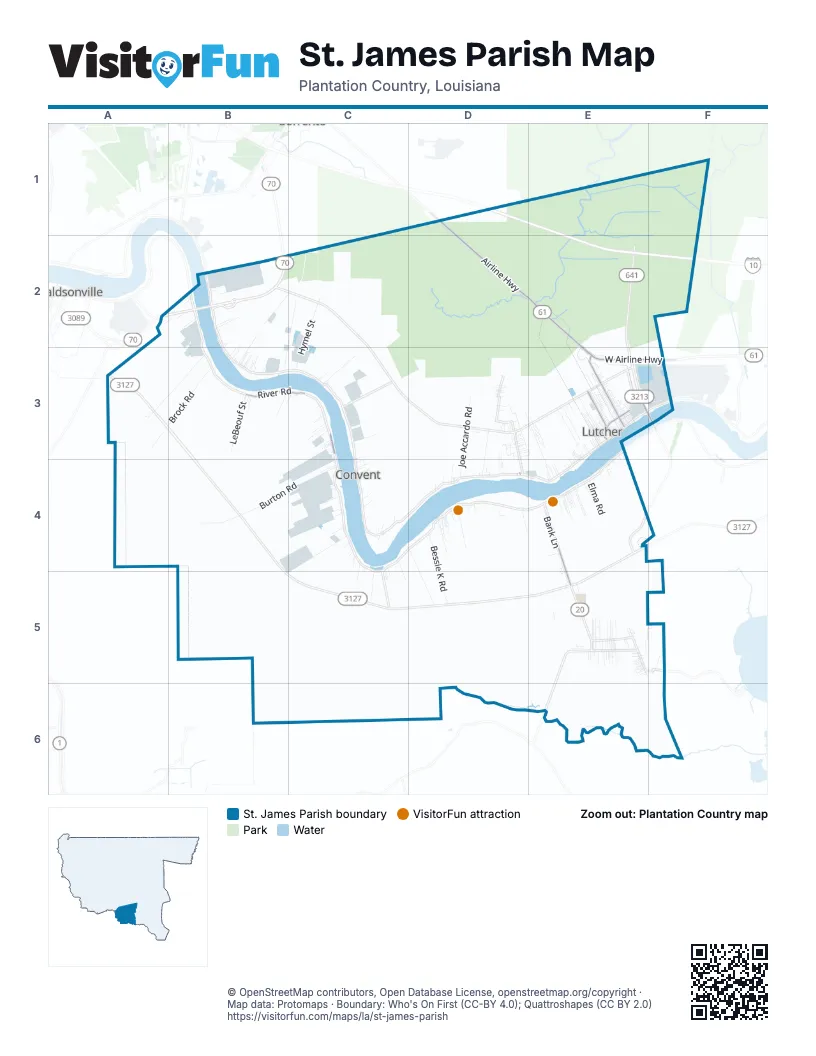
Street index of St. James Parish
Each street on the sheet and the grid squares it crosses.
- Airline HighwayD1, D2, E2, E3
- West Airline HighwayE3, F3
- Gramercy BridgeE3
- River RoadB3, C3
- Louisiana 20E4, E5
- North Airline AvenueE3
- Lutcher AvenueE3
- Main StreetE3
- West Main StreetE3
- Albert StreetE3, D4
- East Main StreetE3
- South Airline AvenueE3
- Brock RoadA3, B3
- Burton RoadB4, C4
- Lapice RoadA3, B3
- Hymel StreetC2, C3, C4
- Joe Accardo RoadD3, D4
- Star Enterprise RoadB2
- Bessie K RoadD4, D5
- Helvetia StreetB2, C2, B3
- Chopin RoadD4, D5
- Sidney Farm RoadC4
- LeBeouf StreetB3
- North King AvenueE3
- Barras StreetC4, C5
- South Martin RoadE3, E4
- Winnie RoadB2, C2, B3
- Romeville StreetC3
- North Nobile StreetE3
- Exxon RoadC4
- Boyce Tower RoadC2
- South Burton RoadB4
- Elma RoadE4
- 2nd StreetE3
- Falgoust StreetC4, E5
- 3rd StreetE3
- Admirals Landing StreetE3
- Belmont LaneD4
- Capline Tank RoadC4
- North Ezidore AvenueE3
- Shell Hill LaneE5, F5
- Baytree StreetD4
- Mbc Plantation RoadC4
- Church StreetE3, E4, E5
- Pine StreetE3, E5
- Oak Alley DriveD4
- North Magnolia StreetE3
- Ballevue Lakes StreetE3
- Winniw RoadB2, B3
- Old Vacherie StreetE4
- Magnolia Heights StreetE4
- North Montz AvenueE3
- Locap RoadC4
- South Bank LaneE4
- King View StreetB3
- West Lebray StreetE3
- Brroklyn RoadE5
- Legion StreetB2
- Hester StreetD3, D4
- North Courseault StreetE3
- Freeport RoadC3
- Department of Energy RoadC4
- Aubrey StreetD4
- School StreetE3
- Freetown StreetC3
- 5th StreetE3
- North Millet AvenueE3
- Burton StreetC4
- East Roussel Road.E3, E4
- Cabanose AvenueE3
- North Central AvenueE3
- North Rosary StreetE5
- Lionel Washington StreetE3
- North Oak StreetE5
- No Name RoadB3
- Burnside StreetB2, E4
- Hester RoadD3
- Convent Station DriveC4
- Pikes Peak StreetC4, C5
- Judge Becnel LaneE4, E5
- Maple StreetE5
- Reverend Doctor Samual JonesD3, D4
- Ellis StreetE3, E5
- Red Falgoust StreetE5
- La Jet RoadC3, C4
- Saint James StreetD3, E4
- North Bank LaneE4
- Longview StreetD3
- High Ridge DriveE5
- Nicole StreetD3
- Salsburg RoadB2
- Kirklin DriveD3, D4
- Kahn StreetD4
- Forrestal StreetE5
- Oak Alley Farm RoadD4
- Celestan StreetC4
- North Pine StreetE3, E5
- Communi StreetC3
- Collins StreetE4
- Ergon RoadC3
- Cypress StreetE3, F5
- Exchange AlleyE3
- East 2nd StreetE3
- Sugarhill StreetB3
- South Railroad StreetE3
- Michel RoadE4
- Cut Cane DriveB3
- Texas StreetE3
- Dey Say StreetE3
- Luther King StreetE4
- Water Tower StreetB3
- Oubre RoadD3
- Redbud StreetE5
- Saint James Co-Op StreetC4
- Stevedoring RoadB3
- Central Project StreetB3
- Perkins StreetE4
- Fern StreetE5
- North Peach StreetE5
- Pecan StreetB3
- Back Quarters StreetE4
- Margaret StreetE5
- Franklin StreetE4
- Cemetery RoadE3
- North Line StreetA2, B2
- Life House StreetA2, B2
- Sugar Estates StreetE5
- Swimming Pool StreetF5
- Bellvue StreetE4
- Magnolia Garden StreetE4
- Carly LaneD3
- Babin Wilson StreetC4
- Harrison StreetD4
- Badeaux DriveC4
- Lilly RoadC3, D3
- North Albert StreetE3
- Falcon Court RoadE3
- Mill StreetB3, C3
- Ester StreetB3
- Le Boukin StreetE4
- Magnolia StreetE3
- Park StreetC3
- Reverend Thomas Scott StreetC4
- Lake Perique DriveE3
- Post Office StreetC4
- Louisiana AvenueE3
- Lucien RoadB3
- Kilmer StreetE4
- Apricot LaneE5
- Canatella StreetC4
- Chicago DriveE4
- East Railroad StreetE3
- Cayette StreetC3
- Domino StreetD4
- Oubre 2 StreetD4
- South Nobile StreetE3
- T Poche StreetE4
- Redwood LaneD3
- North David DriveE3
- Paul Nelson RoadC3
- Brignac StreetE3
- Plantation StreetD3
- Ash StreetE5
- Valcour Aime StreetD4
- North Spruce StreetE5
- Hymel DriveE3
- Saint Luke StreetC4, C5
- Simon StreetE4
- Sugar House StreetD3, E3
- Palm StreetE5
- Pleasant Hill StreetC3
- Brazan RoadE5
- Sycamore StreetE5
- Porrier RoadC3, C4
- South Peach StreetE5
- Antioch StreetE4
- Acorn StreetE5
- Champion StreetE5
- Morgan StreetE3
- Maura StreetD3, E3
- Saint Michaels StreetC4
- South Millet AvenueE3
- Wendy StreetD3, E3
- Desire StreetE5
- Sugar Lakes LaneE3
- Marcelin Rome StreetE3
- Methodist StreetB3
- North Coteau RoadE5
- Gauthreaux RoadB3
- Oak StreetE5
- South Rosary StreetE5
- East 4th StreetE3
- Felicite RoadD4
- Matherne RoadE3
- Poche StreetE3
- Alexander StreetE3
- Evacuation StreetD3
- Levy Gaudet StreetE3
- Melon LaneE5
- Terre Haute StreetE5
- Buena Vista StreetB2
- La Belle Rue RoadE5
- Ann DriveD4
- Leno DriveD4
- Miles StreetE3
- Kenmore DriveD3
- Bon Sejour StreetE3
- Garden Lakes CourtE3
- Schexnayder StreetB3, E3
- Tower RoadE5
- 6th Ward StreetC3
- Frontage RoadB2
- East 1st StreetE3
- Walnut StreetE5
- East LebrayE3
- Haydel StreetC4
- June RoadB2
- Mimosa StreetE5
- Koch RoadC3
- Zenon StreetE4
- Lloyd RoadE5
- Riley StreetD3
- Edwards StreetC3
- Golden Grove RoadE3
- Clinton RoadC4
- Louise RoadE5
- Kinler StreetE3, E4
- Fig StreetE5
- Lena StreetD3
- Leon RoadE5
- Saint Joe RoadD4
- Harrytown LaneE5
- Mulberry StreetE5
- Deroche CircleE3
- East Park AvenueE3
- Lawrence StreetE3
- Lemon StreetE5
- East Arbreed StreetC4, C5
- Cherry StreetE5
- South Coteau RoadE5
- Gravois StreetD3
- Saint Emma StreetC4
- Coco StreetE5
- Mount Calvary StreetB3
- Dennis StreetB3
- Geismar StreetD3
- John C StreetE5
- Capline Dock RoadC4
- Nette StreetE5
- South Fir AvenueE3
- Wayne StreetE3
- Willow StreetE5
- South Mulberry AvenueE3
- Waguespack StreetE3
- Como StreetC3, C4
- 14th StreetE3
- South Spruce StreetE5, F5
- Effie RoadD4
- South Elm AvenueE3
- Weber DriveD4
- Amy StreetD3
- Queen of the Angels RoadC2
- Leblanc StreetD3
- Tupelo LaneD3, D4
- Elizabeth RoadE5
- M & P RoadE3
- Ricky laneD3
- Martin DriveC4, C5
- Oak Tree StreetB2, B3
- Cypress LaneD3
- East 6th StreetE3
- Old Cabanocey RoadC4
- South Plum AvenueE3
- Lotus StreetE5
- North Louque StreetD3
- T-Caillou RoadD3, E3
- Lucky StreetE3, E4
- Lonnie LaneE5
- Orange StreetE5
- South Cherry AvenueE3
- Tribbet StreetB2
- Haas RoadE4
- Lime StreetE5
- Abadie StreetE3, E4
- Hickory LaneE3
- Oubre 1 StreetD4
- Pear StreetE5
- Trudeau StreetC4
- Lilly StreetE5
- South Sycamore AvenueE3
- Brignac RoadD3
- Copalm StreetC3
- Rizzuto StreetD4
- Courthouse StreetC4
- Tregre StreetE5
- Paul Stein StreetE5
- South Oak StreetE3
- Ponderosa StreetD3
- South Angelle StreetD3
- Simon DriveE5
Things to do on the St. James Parish map
Places on the map
- Antioch Cemetery
- Beacon Behavioral Hospital
- Buena Vista Cemetery
- Celestin Cemetery
- Dollar General
- Gramercy
- Gramercy Post Office
- Hester Post Office
- Highway Cemetery
- K.C Hall
- La Vacherie Swimming Club
- Laura Plantation
- Lutcher
- Lutcher Fire Station
- Lutcher High Schools Sports Fields
- Lutcher Park
- Lutcher Post Office
- Manresa House of Retreats
- Miles Memorial Park
- Most Sacred Heart of Jesus Catholic Church
- Mount Calvary Cemetery
- North Vacherie
- Oak Alley Plantation
- Oak Alley Plantation House
- Our Lady of Peace Catholic Church
- Paulina Park
- Paulina Post Office
- Saint James Cemetery
- Saint James Parish
- Saint Joseph Cemetery
- Saint Joseph Plantation
- Saint Michael Cemetery
- Sixth Ward Elementary School
- South Vacherie
- St. James Crude Rail Terminal
- St. James Parish Hospital
- St. Joseph Plantation
- Whitehall Field Ultralightport
Next to St. James Parish
- Donaldsonville
© OpenStreetMap contributors, Open Database License, openstreetmap.org/copyright · Map data: Protomaps · Boundary: Who's On First (CC-BY 4.0); Quattroshapes (CC BY 2.0)















