

Massachusetts map
Bourne map
About 20,508 people live here (Census Bureau, 2024 estimate). The sheet's index lists 300 streets; Sandwich Road, County Road and Orchard Road cross the most grid squares. Things to do inside the boundary: Cape Cod Canal Region and Cataumet Crossing.
Open the map (PDF, US Letter)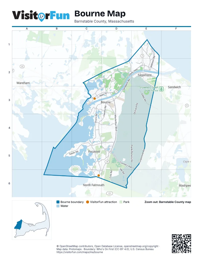
Street index of Bourne
Each street on the sheet and the grid squares it crosses.
- Mid Cape HighwayE2
- Pilgrim HighwayE1, E2
- Pilgrims HighwayE2
- MacArthur BoulevardD3, D4, D5
- Sandwich RoadD2, E2, D3, D5, C6, D6
- Scenic HighwayD2, E2, D3
- State RoadE1, E2
- Canal StreetE2, C3
- Bourne BridgeD3
- Mid-Cape ConnectorE2
- Otis Air Force Base RotaryD5
- North Bourne RotaryD3
- Sandwich Road ConnectorD3
- MacArthur Boulevard Southbound Collector Distribution RoadD4
- Bourne RotaryD3
- County RoadD3, C4, D4, C5, D5, C6
- Shore RoadC3, D3, C4, C5
- Head of the Bay RoadC2, D2, D3
- Old Plymouth RoadE1, E2
- Barlows Landing RoadC5, D5
- Clay Pond RoadC4, D4
- Main StreetC3, D3
- Waterhouse RoadD3, D4
- Buzzards Bay BypassC3, D3
- Scusset Beach RoadE2
- Cranberry HighwayE2, C3
- Trowbridge RoadD3
- Lake DriveD5
- Adams StreetE2
- Meetinghouse LaneE2
- Long Hill RoadD5
- Old County RoadD5
- Lake Drive ExtendedD5
- Beach StreetC4
- Shore RouteD5
- West End RotaryC3
- Scussett Beach RoadE2
- Red Brook RoadC2
- North Falmouth HighwayC6
- Connery AvenueD5, E5
- Scraggy Neck RoadB5, C5, B6, C6
- Wings Neck RoadB5, C5
- Bournedale RoadD2
- Cole RoadD5, D6
- Gibbs RoadE2, E3
- Williston RoadE1, E2
- Mashnee RoadC3, C4
- Herring Pond RoadD1, E1, D2, E2
- Puritan RoadC3, D3
- Red Brook Harbor RoadC5, C6
- Church LaneE2
- Standish RoadE1, E2
- Clark RoadE1
- Norris RoadE1
- Academy DriveC3
- Williams AvenueD5
- Old Dam RoadC3, D3
- Presidents RoadC3
- Megansett RoadC6
- Monument Neck RoadC3
- Plymouth LaneD2, D5
- Saint Margarets StreetC3
- Sagamore RoadE1
- Old Bridge RoadD3
- Squeteague Harbor RoadC6
- Vickerson AvenueE1
- Midway RoadC4
- Samoset RoadE1
- Scraggy Neck Road ExtensionC6, D6
- Peaked Cliff RoadE1
- Ben Abbey RoadE2
- Shawmut RoadE1
- McKenna RoadD5
- Garnet AvenueC6
- Turpentine RoadE4, E5, D6, E6
- Frank Perkins RoadD4, E4, D5, E5
- Orchard RoadD2, E2, E3, D4, E4
- Forestdale-Pocasset-Sandwich RoadE4, D5, E5
- Curtis BoulevardD6
- Lee RoadD5, D6
- Circuit AvenueC5
- Veterans WayD3, D5
- Monument Beach RoadD4, E4
- Connector DriveE2, E3
- Estey RoadD5
- Wheelock RoadD4, E4
- South RoadB5, C5
- Spinnaker LaneD4, D5
- Minton RoadE5
- Valley Bars RoadC4, D4
- Forestdale-Pocasset RoadE5
- Winston AvenueE1, E2
- East Hospital RoadD5, D6
- Brookside RoadD3, D4
- Emmons RoadC4
- Deseret DriveD2, D3
- Tara TerraceD4
- Memorial CircleD5
- Sachem DriveE2
- West Hospital RoadD5, D6
- Elgin RoadC5
- Bennets Neck DriveC4
- Ernest Valeri RoadD2
- Howe RoadE5
- Portside DriveD4, D5
- Siasconset DriveE2
- Weatherdeck DriveD3
- Chartwell DriveE1, E2
- Fieldwood DriveE2
- Club House DriveC5
- Vandenbura DriveD6
- Bellavista DriveC5
- Harbor Lights RoadD3
- Tahanto RoadC4, C5
- Herbert RoadE5
- Dump RoadD3, D4
- Canal Service RoadE2, C3
- Mirasol DriveD2
- Jonathan Bourne DriveD4
- High Ridge DriveD2, D3
- Old North RoadC5
- Yearling Run RoadD2
- Thom AvenueC4, D4
- Eel Pond RoadC4
- Howard AvenueC4, D4
- North RoadC5
- Roundhouse RoadD4
- Shaker DriveD4
- Phillips RoadE1
- Hilltop DriveE2
- Great Rock RoadD3
- Noreast DriveE1
- Diandy RoadE2
- Harbor DriveC5
- Lemay AvenueD6
- Hunter AvenueD6
- Lewis Point RoadC2, C3
- Concord LaneD5
- Maple StreetC3, D3
- Rocky Point RoadC3, C4
- Salt Marsh LaneC5
- Kelly StreetD6
- Ocean Pines DriveE1, E2
- Sea Breeze DriveC3
- Clubhouse DriveC5, D5
- Dry Cedar Swamp RoadD2
- Heather Hill RoadD2
- Cotuit RoadD3
- Hersey LaneC4, D4
- Patriot LaneD5
- Jefferson RoadC3
- Tower LaneC3
- Harmony Hill RoadD4
- Mayflower WayD5, D6
- Chidlaw StreetD6
- Pasture RoadC6
- Old Head of the Bay RoadC2, D2
- Sycamore AvenueE1
- Depot RoadC5, C6
- Commital Services Shelter LoopD5
- Westerly DriveD4
- Harwood DriveC4
- Cedar Point DriveC5
- Rip Van Winkle WayC3
- Maryland AvenueC4
- Winsor RoadC5
- Clarissa Joseph RoadD2
- Quaker LaneD4
- Finch LaneD3
- Bennington BoulevardD5
- Briarwood LaneC4
- Harlow Farm RoadE1
- Settlers WayD2
- Ridgehill LaneE1
- Cranberry RoadC3, D3
- Sheriff's PlaceD5
- Windrush AvenueD5
- Carpenter AvenueD6
- Michael RoadC5, D5
- Little Bay LaneD2, D3
- Bell Buoy RoadC5
- Old Monument Neck RoadC3, D3
- Hunters Brook RoadE2
- Catskill RoadC3
- Chamber Rock RoadD2
- Handy RoadD5
- Valley Farm RoadD5
- Kendall Rae PlaceC3, D3
- Elm AvenueC4, C6
- Spruce DriveC5
- Armory RoadC3
- Pryer DriveD4, D5
- Maintenance RoadD5
- Tech DriveD3
- Beebe StreetE5
- Whimbrel DriveC6, D6
- Nye LaneC2
- Pleasant StreetE2
- Perry AvenueD3
- Pine Ridge RoadC2
- Andrew RoadE2
- Nightingale Pond RoadD3
- Nauset RoadE1
- Wallace AvenueC3
- Arlington DriveC3
- Norstad StreetD6
- Aptucxet RoadD3
- Tibbetts StreetD6
- Gilder RoadC3
- Tecumseh RoadE1
- Studio DriveC3
- Lincoln AvenueC3
- Commerce Park RoadD4, D5
- Keene StreetD3
- Rice AvenueD5
- Vesper DriveC5, D5
- Captains RowC4
- Gated CmmunityC4, D4
- Holt RoadC3
- Colonel DriveD3
- Jillian DriveE2
- Sagamore Rifle Club Access RoadD2
- Carnoustie RoadD3
- Foster Howard RoadD5
- Colony AvenueD4
- Tinker StreetD6
- Gibson StreetD6
- Cohasset AvenueC3
- Buttermilk WayC3
- Briggs AvenueD4
- Observatory LaneD5
- Kenwood RoadC5
- Wayne RoadE2
- Olofson DriveC6
- Ocean AvenueC6
- Cliff RoadC4, D4
- Sanderling DriveC6, D6
- USS Constitution AvenueD5
- Washington AvenueC3
- Harrison AvenueC3
- Long Boat RoadE2
- Shells WayE2
- Mizzen LaneD3
- Agawam Point RoadC3
- Keith RoadC5
- Baxendale RoadC6
- Gaffield AvenueC4
- Bourne DriveD5
- Penelope RoadC4, D4
- Sheppard RoadE1
- Cortege LanesD5
- Pinehurst DriveD4
- Douglas AvenueC4
- Colonial RoadC3
- Cypress StreetD3
- Marsh Pond RoadE2
- Heritage DriveD3
- Sanford StreetD4
- Oakbluff RoadE1
- Homestead RoadE2
- Leeward RoadC4
- Tiffany RoadC4, D4
- Mooring RoadC4
- Turnberry RoadD3, D4
- Hunters Ridge RoadE2
- Lord Hayford RoadE1
- White StreetD6
- Kayajan AvenueC3
- Linwood AvenueC4
- Cove LaneC5
- Osborne Pond RoadD6
- Chenault RoadD5
- Buzzards Bay AvenueC3
- Luigi AvenueE2
- Ramey StreetD5, E5
- Ships WayD3
- Avery RoadD5
- Little Sandy Pond RoadD2
- Edith AvenueC3, D3
- Doolittle AvenueD5, D6
- Oak AvenueC6
- Crowell RoadE1
- North Beach AvenueC4
- Shipyard LaneC5
- Bosuns LaneD3
- Surrey LaneD3
- Bourne Neck DriveC3
- Manomet RoadE1
- Marjorie AvenueD5
- Benedict RoadC3
- Black Pond RoadD2, E2
- Everett RoadD3
- Rope WalkC4
- Alden AvenueC3
- Lafayette AvenueC3
- Pleasure Point RoadE2
- Thorne RoadC3
- Bluff RoadE2
- Laura LaneD4
- Virginia RoadC5
Things to do on the Bourne map
Places on the map
- Animal Friends Summer School
- Barnstable County Hospital
- Bassett's Island
- Bayview Campground
- Beaton Bog
- Bourne Marina
- Bourne Public Schools
- Bourne Water District
- Buzzards Bay Park
- Canal Wellfield
- Cape Cod
- Cape Cod Canal Access
- Cape Cod Space Force Station
- Cataumet
- Cataumet Wellfield
- Cliffside Estates
- Deer Horn Hill Conservation Area
- Flax Pond
- Former Cape Cod Aggregates Bourne Pit
- Four Ponds Conservation Area
- Four Ponds Loop
- Goat Pasture Pond
- Ingersoll
- Joint Base Cape Cod
- Mashnee Island
- Megansett Harbor
- Monument Beach
- North Sagamore Woodlots
- Old Field Pond Preserve
- Otis Air Force Base Landfill
- Pocasset
- Pocasset Golf Club
- Sagamore
- Sagamore Beach
- Scraggy Neck
- Shawme-Crowell State Forest
- The Brookside Club
- The Strand
- Town Forest
- Ultimate Battleground
Next to Bourne
- Mashpee map
- North Falmouth
- Sandwich
- Wareham map
© OpenStreetMap contributors, Open Database License, openstreetmap.org/copyright · Map data: Protomaps · Boundary: Who's On First (CC-BY 4.0); U.S. Census Bureau















