

Massachusetts map
Cambridge map
About 121,186 people live here (Census Bureau, 2024 estimate). The sheet's index lists 300 streets; Massachusetts Avenue, Memorial Drive and Concord Avenue cross the most grid squares. Things to do inside the boundary: CambridgeSide, Charles River Boat Company and Harvard Art Museums.
Open the map (PDF, US Letter)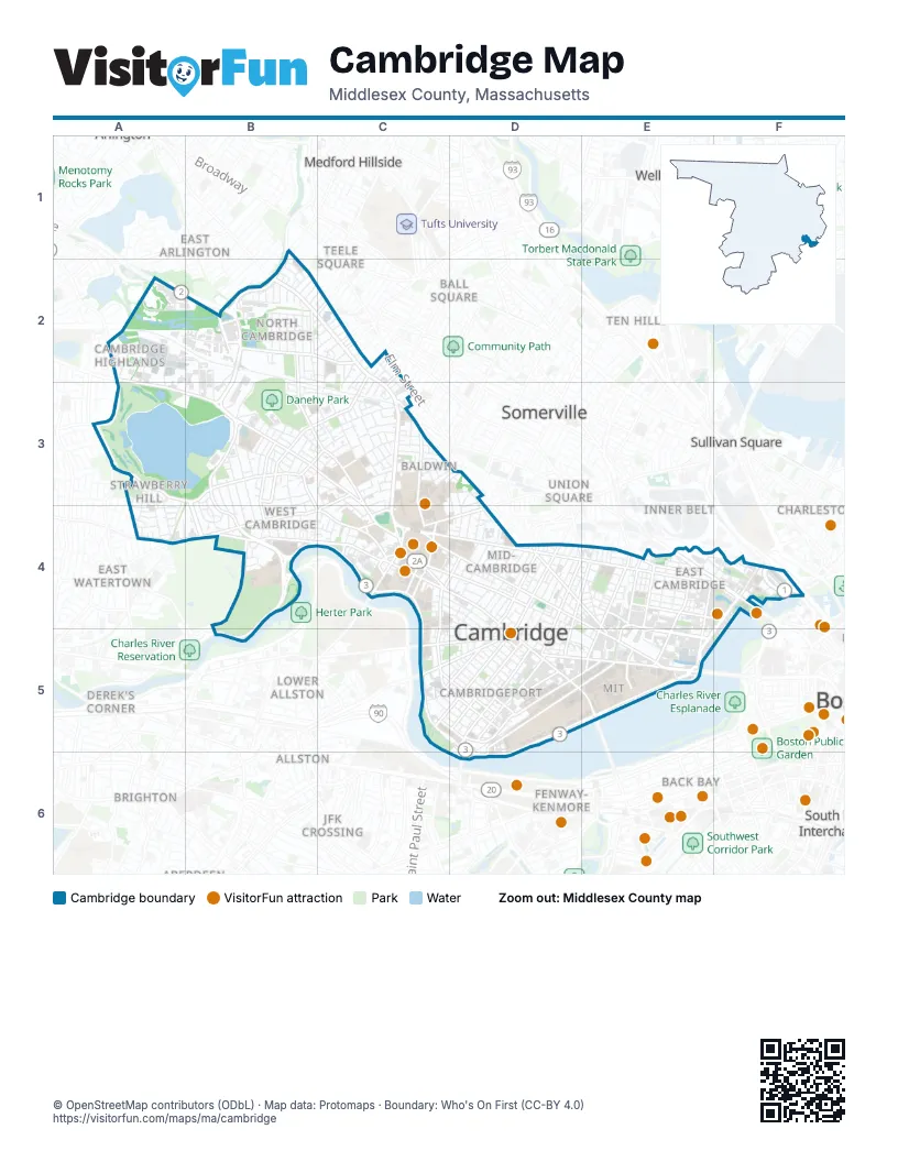
Street index of Cambridge
Each street on the sheet and the grid squares it crosses.
- Concord TurnpikeA2, B2
- Leverett Circle ConnectorF4
- Massachusetts AvenueB2, C2, C3, C4, D4, D5, E5
- Memorial DriveB4, C4, C5, D5, E5, D6
- Cambridge StreetC4, D4, E4, F4
- Concord AvenueA2, A3, B3, C3, C4
- Mount Auburn StreetA4, B4, C4
- BroadwayC4, D4, E4, E5
- Huron AvenueA3, B3, C3
- Alewife Brook ParkwayB1, B2, B3
- Brattle StreetB4, C4
- Greenough BoulevardB4, B5
- Fresh Pond ParkwayB3, B4
- Main StreetD5, E5
- Garden StreetB3, C3, C4
- Monsignor O'Brien HighwayE4, F4
- Edwin H. Land BoulevardF4, E5
- Brookline StreetD5
- First StreetE4, E5
- Hampshire StreetD4, E4, E5
- Prospect StreetD4, D5
- Sidney StreetD5
- Western AvenueC5, D5
- River StreetC5, D5
- Gerry's Landing RoadB4
- Aberdeen AvenueB3, B4
- Waverly StreetD5
- John F. Kennedy StreetC4
- Somerville AvenueC3
- Charlestown AvenueF4
- Belmont StreetA4
- Boston University BridgeD5, D6
- Hawthorn StreetC4
- Connector to Eliot BridgeB4
- Eliot BridgeB4
- Charles River Dam RoadF4
- Austin StreetF4
- Eliot StreetC4
- Reid RotaryD5
- Waterhouse StreetC4
- Longfellow BridgeE5
- Alewife Brook-Concord Avenue RotaryB3
- Peabody StreetC4
- Sozio RotaryB3
- Beacon StreetD4
- Sidney Street ExtensionD5
- Harvard StreetC4, D4, D5, E5
- Putnam AvenueC4, C5, D5
- Binney StreetE4, E5
- Vassar StreetD5, E5, D6
- Columbia StreetD4, E4, D5
- Third StreetE4, E5
- Albany StreetD5, E5
- Pleasant StreetD4, C5, D5
- Inman StreetD4
- Cambridgepark DriveA2, B2
- Galileo Galilei WayE4, E5
- Gore StreetE4
- Kirkland StreetC4, D4
- Trowbridge StreetC4, D4
- Webster AvenueE4
- Cardinal Medeiros AvenueE4
- Erie StreetD5
- Blanchard RoadA2, A3
- Alewife Station Access RoadB2
- Portland StreetE4, E5
- Steel PlaceB2
- Quincy StreetC4
- Craigie StreetC3, C4
- Day StreetC2
- Beech StreetC2, C3
- Mason StreetC4
- Warren StreetE4
- Dover StreetC2
- Lambert StreetE4
- James StreetC4
- Alewife T Station Access RoadB2
- Brighton StreetA2
- Green StreetC4, D4, D5
- Walden StreetC2, B3, C3
- Windsor StreetD4, E4, D5
- Rindge AvenueB2, C2
- Magazine StreetC5, D5
- Pearl StreetD5
- Fayerweather StreetB3, B4
- Sherman StreetB2, B3, C3
- Oxford StreetC3, C4
- Allston StreetC5, D5
- Charles StreetE4
- Sparks StreetB3, B4
- Sixth StreetE4
- Linnaean StreetC3
- Coolidge AvenueB4
- Fulkerson StreetE4
- Reservoir StreetB3
- Ames StreetE5
- Cedar StreetB2
- Pacific StreetD5
- Landsdowne StreetD5
- Plympton StreetC4
- Granite StreetC5, D5
- Cottage StreetD5
- North First StreetE4, F4
- DeWolfe StreetC4
- Bow StreetC4
- Cameron AvenueB2, C2
- Cambridgeside PlaceE4, F4
- Springfield StreetD4
- Arsenal SquareC3
- Franklin StreetC4, D4, D5
- Norfolk StreetD4, D5
- Rogers StreetE4, E5, F5
- Upland RoadC3
- Thorndike StreetE4
- Lakeview AvenueB3, B4
- Fifth StreetE4, E5
- Second StreetE4, E5
- Acorn Park DriveA2, B2
- Elm StreetD4
- Lexington AvenueB3, B4
- Spring StreetE4
- River AvenueB4, B5
- Amherst AlleyD5
- Raymond StreetC3
- Otis StreetE4
- Pemberton StreetB2, C2, C3
- Chestnut StreetC5, D5
- Vassal LaneB3
- Irving StreetD3, D4
- Tremont StreetD4
- Bishop Allen DriveD4, D5
- Appleton StreetB3, B4
- Cambridge ParkwayF4, E5, F5
- Larch RoadB3, B4
- Dana StreetD4
- Washington StreetD5, E5
- Kinnaird StreetC4, D4, D5
- Bent StreetE4
- Hurley StreetE4
- Richdale AvenueC3
- Larchwood DriveB3, B4
- Ellery StreetD4
- Clarendon AvenueB2
- Hancock StreetD4
- Holworthy StreetA3, A4
- Dudley StreetB2, C2
- Sciarappa StreetE4
- Water StreetE4, F4
- Park AvenueA3, A4, B4, B5
- Harvey StreetB2
- Cushing StreetA3, A4
- Francis AvenueC3, D3, D4
- Chilton StreetB3
- Maple AvenueB4, D4
- Wendell StreetC3
- Fresh Pond LaneB3, B4
- Sacramento StreetC3
- Morgan AvenueE4, F4
- Walker StreetC3
- Coolidge HillB4
- Orchard StreetC2, C3
- New StreetB2, B3
- Amherst StreetD5, E5
- Willow StreetE4
- Banks StreetC4, C5
- Shepard StreetC3
- Whittemore AvenueB2
- Smith PlaceA2, A3
- Market StreetD4, E4
- Auburn StreetD5
- Hamilton StreetD5
- Foster StreetB4, C4
- Grozier RoadB3, B4
- Antrim StreetD4
- Jackson StreetB2
- Howard StreetD4, D5
- Berkshire StreetE4
- Clay StreetB2
- Clifton StreetB2
- Montgomery StreetB2
- Reed StreetB2
- Highland StreetB3
- Haskell StreetC2, C3
- Winchester AvenueB4, B5
- Henry StreetD5
- Prentiss StreetC3
- Fayette StreetD4
- Lee StreetD4
- Avon Hill StreetC3
- Fawcett StreetB2, B3
- Oxford AvenueA3, A4
- Amory StreetD4
- Berkeley StreetC3, C4
- Meadow WayB4
- Buckingham StreetC3, C4
- Washington AvenueC3
- Essex StreetD4, D5
- Prescott StreetC4
- Garden AvenueB4
- Cherry StreetD4, D5
- Dunster StreetC4
- Plymouth StreetD4, E4
- Linskey WayE5
- Chauncy StreetC3
- Wheeler StreetB2, B3
- Jacobs StreetF4
- Terminal RoadB2, B3
- Hammond StreetC3
- Cogswell AvenueC2, C3
- Bristol StreetD4, E4
- Field StreetB3
- Fawcett Street ExtensionA2, B2
- Roberts RoadD4
- Arlington StreetC3
- Coolidge Hill RoadB4
- Walden Square RoadB3, C3
- Mooney StreetA2
- Ash StreetC4
- Jay StreetD4, D5
- Langdon StreetC3
- Union StreetD4, E4
- Highland AvenueD4
- Alpine StreetB3
- Fairmont StreetC5, D5
- Seventh StreetE4
- Gray Gardens EastC3
- Pine StreetD4, D5
- Education CircleF4
- Follen StreetC3, C4
- Greenwood AvenueB4
- Meadow AvenueB4
- Mill StreetC4
- Normandy AvenueA2
- Forest StreetC3
- Lancaster StreetC3
- Griswold StreetA2
- Rice StreetB2, C2
- Bellis CircleB3
- Norton CircleA3
- Standish StreetB3
- Ellsworth AvenueD4
- Technology SquareE5
- State StreetD5
- Holyoke StreetC4
- Bigelow StreetD4
- Frost StreetC3
- Lincoln StreetD4, E4
- Middlesex StreetB2
- Greenough AvenueB4, D4
- Martin StreetC3
- Everett StreetC3
- Garfield StreetC3
- Lowell StreetB4
- Matignon RoadB2
- Granville RoadB3
- William StreetD5
- Athenaeum StreetE5
- May StreetA3, A4
- Moulton StreetA2, B2, A3, B3
- Glassworks AvenueF4
- Clinton StreetD4
- Lawn StreetA4
- Porter RoadC3
- Purrington StreetD5
- Museum StreetC3, D3
- Saville StreetB3
- Fairview AvenueA3
- Avon StreetC3
- Blackstone StreetC5
- Willow AvenueB4, B5
- Bowdoin StreetC3
- Pilgrim StreetD5
- Scott StreetD3, D4
- Yerxa RoadC2, C3
- Harding StreetE4
- Sargent StreetB2
- Education StreetF4
- Thingvalla AvenueA4
- Mount Vernon StreetC3
- Kelly RoadD5
- Wadsworth StreetE5
- Willard StreetC4
- Winter StreetE4
- Potter StreetE5
- Columbus AvenueB2
- Hollis StreetC2
- Winslow StreetB3, C3
- Prospect AvenueB4
- Linden AvenueB4
- Divinity AvenueC3, C4
- Hubbard Park RoadB4
- Magee StreetC4, D4, D5
- Hovey AvenueD4
- Seagrave RoadB2
- Roseland StreetC3
- Hubbard AvenueC3
- Stearns StreetB3, C3
- Russell StreetC2
- Longfellow ParkC4
- Brewster StreetB3, B4
Things to do on the Cambridge map
Places on the map
- 57 Alumni Pool
- Adams House Mail Center
- Alewife
- Andover-Harvard Theological Library
- Bakalar Music Library
- Baldwin
- Barker Library
- BBN Technologies
- Briggs Field
- Bulfinch Marsh
- Cabot House Mail Center
- Cabot Science Library
- Cambridge Cemetery
- Cambridge Highlands
- Cambridge Parkway
- Cambridgeport
- Danehy Park
- East Cambridge
- Fresh Pond
- Fresh Pond Golf Course
- Fresh Pond Mall
- Harvard Yard
- John F Kennedy School of Government
- Kingsley Park
- Lusitania Woods
- Massachusetts Institute of Technology
- Massachusetts National Guard
- Mid-Cambridge
- MIT
- Neighborhood Nine
- North Cambridge
- Riverside
- Strawberry Hill
- Technology Square
- The Port
- University Park
- W34 Johnson Athletic Center
- Wellington-Harrington
- West Cambridge
Next to Cambridge
- Allston
- Allston Heights
- Allston Village
- Audubon Circle
- Back Bay
- Ball Square
- Barry's Corner
- Bay Village
- Beacon Hill
- Brickbottom
- Brighton
- Brighton Center
- Bugg Village
- Charlestown
- Chinatown
- Coolidge Corner
- Corey Hill
- Davis Square
- Derek's Corner
- East Arlington
- East Somerville
- East Watertown
- Fenway-Kenmore
- Hendersonville
- Inner Belt
- JFK Crossing
- Kensington Park Historic District
- Lower Allston
- Magoun Square
- Medford Hillside
- Mount Auburn
- Mount Vernon Street Historic District
- North Brighton
- North Brookline
- Old Ship Street Historic District
- Packard's Corner
- Prospect Hill
- Somerville map
- South Bay Interchange
- South End
- South Medford
- Spring Hill
- Spring Hill Historic District
- Sullivan Square
- Teele Square
- Ten Hills
- Union Square
- Wellington
- West End
- West Everett
- West Somerville
- Winter Hill
© OpenStreetMap contributors, Open Database License, openstreetmap.org/copyright · Map data: Protomaps · Boundary: Who's On First (CC-BY 4.0)