

Maryland map
Annapolis map
About 40,689 people live here (Census Bureau, 2024 estimate). The sheet's index lists 300 streets; Forest Drive, Taylor Avenue and Spa Road cross the most grid squares. Things to do inside the boundary: Annapolis & Anne Arundel County, Banneker-Douglass-Tubman Museum and Hammond–Harwood House.
Open the map (PDF, US Letter)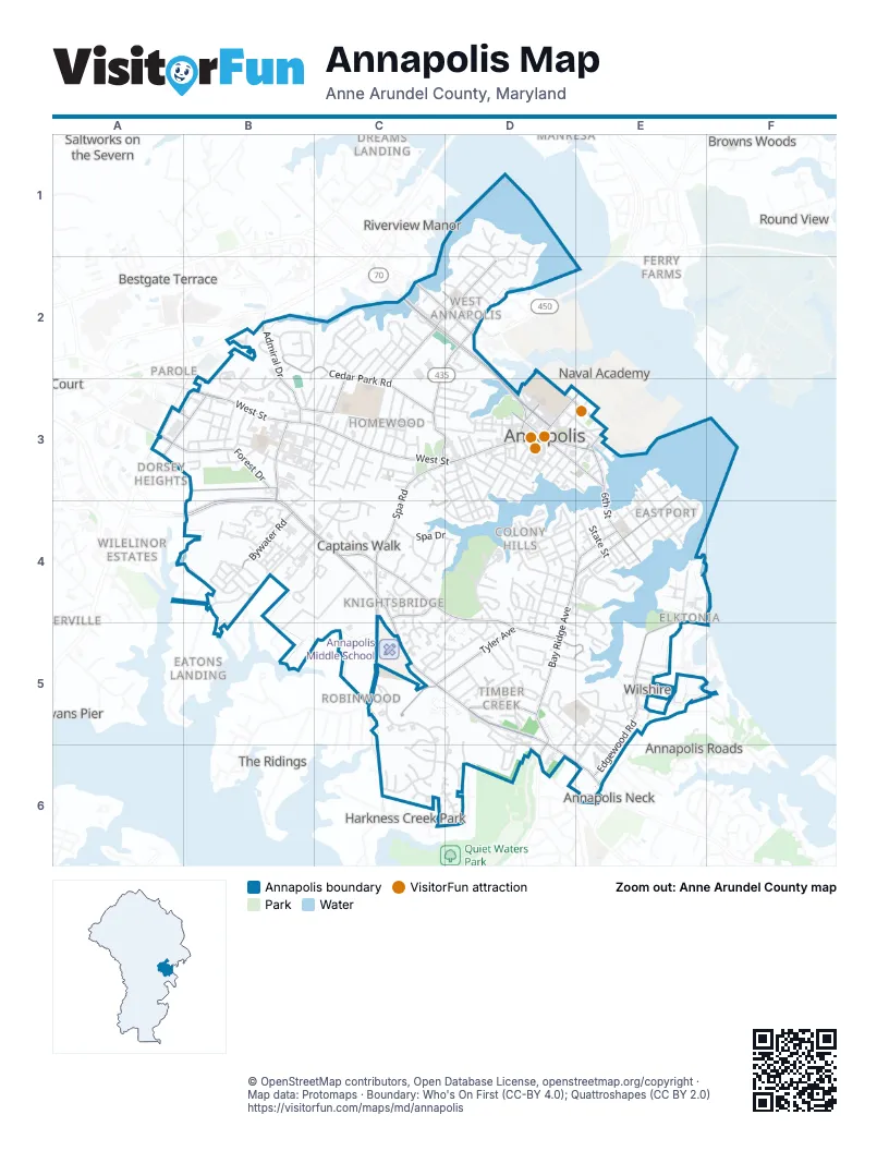
Street index of Annapolis
Each street on the sheet and the grid squares it crosses.
- Forest DriveA3, B3, B4, C4, C5, D5, D6
- West StreetB3, C3, D3
- Roscoe Rowe BoulevardC2, D2, D3
- Hilltop LaneC4, D4, D5
- Aris T Allen BoulevardB3, B4
- Taylor AvenueC2, D2, C3, D3
- Bladen StreetD3
- Solomons Island RoadA3
- Calvert StreetD3
- Westgate CircleC3, D3
- Baltimore BoulevardD2
- Spa RoadC3, D3, C4, C5
- Bay Ridge AvenueD4, E4, D5, D6
- Chesapeake AvenueE3, E4
- Chinquapin Round RoadB3, B4
- Ridgely AvenueC2, D2
- 6th StreetE3, E4
- Old Solomons Island RoadA3, B3
- King George StreetD2, D3, E3
- Duke of Gloucester StreetD3, E3
- Bay Ridge RoadD6, E6
- College AvenueD3
- Main StreetD3, E3
- Compromise StreetE3
- Northwest StreetD3
- Church CircleD3
- Tyler AvenueC5, D5, E5
- Edgewood RoadE4, E5, E6
- Cedar Park RoadB2, C2, C3
- Poplar AvenueB3, C3
- Admiral DriveB2, B3
- Melvin AvenueC2, D2
- Fairfax RoadB3
- Bywater RoadB4
- Farragut RoadC2, C3
- Forest Hills AvenueD5
- Harness Creek RoadC5, C6
- Annapolis StreetC2, D2
- Gemini DriveC4
- Windell AvenueC2, C3
- Randall StreetE3
- Hillsmere DriveD6
- Market SpaceE3
- Somerville RoadB3
- Hunt Meadow DriveC5, C6
- South Cherry Grove AvenueC3, B4, C4
- Chester AvenueE4
- Crystal Spring Farm RoadB4, C4, B5
- President StreetD4, D5
- Georgetown RoadE5, E6
- Dewey DriveC2
- Primrose RoadD4, D5
- Greenbriar LaneB4
- Windwhisper LaneE5
- Severn AvenueE3, E4
- Mas Que Farm RoadB5, C5
- Halsey RoadB2
- Newtowne DriveB4, C4
- Annapolis Neck RoadD5, D6
- Boucher AvenueD4, E4
- Giddings AvenueD2
- Cedar Ridge CourtD5
- Youngs Farm RoadD4, C5, D5
- McGuckian StreetB3, C3
- Riding Ridge RoadC6, D6
- Lafayette AvenueD3, D4
- Victor ParkwayD5, E5, E6
- Silopanna RoadC4
- Southgate AvenueD3
- Monterey AvenueC2, D2
- Wardour DriveD1, D2
- Janwall StreetD5
- 2nd StreetE3, E4
- Williams DriveC2
- Madison StreetD4
- Garden Gate LaneD4, C5, D5
- Monticello AvenueD3, D4
- Franklin StreetD3
- Prince George StreetD3, E3
- Glen AvenueC3
- Burnside StreetE4
- Locust AvenueC3
- Copeland StreetB4
- Sumner RoadC2, C3
- Breakwater DriveE5, E6
- Amos Garrett BoulevardD3, D4
- 1st StreetE3, E4
- Cypress RoadD5, E5, D6
- Hunting Wood RoadC5, D5, D6
- Virginia AvenueB3, C3
- Americana DriveE4
- North Linden AvenueC3
- State StreetE4
- Lake Heron DriveE5
- Boxwood RoadC4
- Bembe Beach RoadE4
- Pearson Point PlaceB4
- Harness Creek View CourtC6, D6
- Silverwood CircleE5, E6
- Truxtun Park RoadD4
- Bens DriveD5
- Monroe StreetD4, E4
- South Southwood AvenueC3
- Fairview AvenueD4, E4, E5
- Warren DriveD5, E5
- Crisfield WayB4
- Genessee StreetC3, D3
- Brashears StreetD4
- Clay StreetD3
- Gibson RoadC2, C3
- Tucker StreetC2, D2
- Eastern AvenueE4
- Loew's Access RoadC3, D3
- Woodlawn AvenueC3
- Chase StreetC3, D3, D4
- Woods RoadB4
- Spa View AvenueD4
- Rosecrest DriveC5, D5
- Hicks AvenueB3
- Van Buren StreetD4
- Jefferson StreetD4, E4
- Woods DriveD5
- Legion AvenueB3, C3
- Norwood RoadD1, D2
- Forbes StreetC2, D2
- McKendree AvenueC3
- Edgewood AvenueB3
- Claude StreetD1, D2
- Hyde Park DriveE5
- Moreland ParkwayB2, B3
- Stilly WayD6
- Cathedral StreetD3
- Dominoe RoadB3
- Spa DriveC4, D4
- Capital DriveB2, B3
- Parole StreetB3
- Childs Point RoadB4
- Margaret AvenueB3, C3
- Gentry CourtC4
- Edelmar DriveD4, D5
- Captains CircleB2
- Pilot House DriveB4
- 5th StreetE4
- Drew StreetB3
- Herbert Sachs BoulevardD2
- Merryman RoadC4
- Saddle Ridge RoadC6
- State CircleD3
- Conduit StreetD3
- Hawkins LaneC4
- Lincoln DriveB3
- Bonny WayD5, D6
- Marda LaneD5
- George AvenueB3
- Dogwood RoadD5, E5
- McKinley StreetD4
- Bay Front DriveE4
- Catlyn PlaceC4
- 4th StreetE4
- Spa Creek LandingD4
- Maura DriveE5
- South StreetD3
- Shiley StreetD2
- East StreetD3, E3
- Smithville StreetC3
- Baldridge RoadC2
- Hilltop Lane Ser DriveC4
- Maple AvenueC3
- Washington StreetE4
- Porter DriveC2
- Janice DriveD5, E5
- Roselawn RoadC5, D5
- Archwood AvenueD3, D4
- Homewood LaneC4
- Quiet Waters PlaceD5, D6
- Dulaney RoadC4
- Maryland AvenueD3, E3
- Timber Creek DriveD5
- Tolson StreetD2
- Summerfield DriveD5
- Yachtsman WayE5
- Bloomsbury SquareD3
- Springdale AvenueD5, E5
- Dorsey AvenueB3
- Heritage CourtC4
- Glenwood StreetC3, D3
- Melrose StreetC3, D3
- Van Buren DriveD4
- Belle DriveB4
- Steele AvenueD3
- Fox Hollow LaneD5, D6
- Wainwright DriveC2
- President Point DriveD4
- Wells AvenueD4, E4
- Yawl RoadB4
- Langdon CourtD5
- Howard Dignen AlleyE4
- Arbor Hill RoadC5
- Murray AvenueD3
- Carrollton RoadE5
- Saint John's StreetD3
- Howison RoadC2
- Adams StreetD4, E4
- Chesapeake Harbour DriveE5
- Croll DriveB3
- Shaw StreetD3
- Shipwright StreetD3, E3
- Upshur RoadD3
- Windsor AvenueD4
- Coybay DriveB4
- Milkshake LaneD4, D5
- Regent StreetC4
- Bristol DriveC2
- West Washington StreetD3
- Obery CourtD3
- Creek DriveD4
- Kensington WayE5
- Charles StreetD3
- Carriage Run RoadC5, C6
- Norman DriveE4
- Ritchie LaneB3, C3
- Market StreetD3
- August DriveD4
- Pump House RoadD4
- Edgewood Green CourtE5
- Nimitz DriveB2
- Carver StreetB3
- Vanguard LaneB4, C4
- Gross AvenueC3
- Jackson StreetD4
- Academy StreetD3, D4
- Pindell AvenueC3
- Claibourne RoadE5, F5
- City Sewage Plant RoadE5
- Chatham LaneC4
- Klakring RoadE4
- Thom DriveD5
- Bowman DriveB3
- Colonial AvenueD3
- Juliana Circle EastC4
- 3rd StreetE4
- South Homeland AvenueC3
- Barbud LaneD5
- Gibralter AvenueB3
- North Cherry Grove AvenueC3
- Center StreetB3
- Atwater DriveB4
- Rogers Heights RoadC2
- Rosewood StreetB3
- Annapolis Walk DriveB4
- Skippers LaneB4, C4
- Bunche StreetB3
- Third StreetE3, E4
- Ludlow RoadC2
- Schley RoadC2
- Smith AvenueD3, D4
- Annapolitan LaneB4
- Hudson StreetB2, B3
- Stonecreek RoadC4, C5
- Simms DriveC2
- Enclave CourtC4
- Granada AvenueD4
- Harness Creek View DriveC6, D6
- Bowie AvenueB3
- Parkwood AvenueD5, E5
- Cross StreetE4, E5
- Louis DriveB3, B4
- Munroe CourtD3
- Brewer AvenueC3
- McDonough RoadB2
- Brightwater DriveB4
- Highland AvenueD4, E4
- Balch RoadD3
- Elliott RoadD4, D5
- Georgetown CourtE5, D6, E6
- Jefferson PlaceD3
- King James Landing RoadE5
- Westwood RoadD1
- Acton RoadC4, D4
- Alder RoadD5
- Lockwood CourtD4
- Cobblestone RoadC5, D5
- Thompson StreetD3
- Amberstone CourtD5
- Boxwood CourtC4
- Conley DriveD5
- Elizabeth DriveE4
- Bowman CourtB3
- Newman StreetE3
- Segelken LaneD2
- Bricin StreetD5
- Steffen Point RoadC2
- Westbridge DriveB3
- Asher DriveC6
- Graff CourtD5
- Berwick DriveD5
- Rockwell CourtC5
- Stewart AvenueD3
- Francis Noel WayB3
- Bridle Path LaneC6
Things to do on the Annapolis map
Places on the map
- 7-Eleven
- A L Goodies General Store
- ABC Supply
- Acton's Landing
- Adams on Fourth
- Adams Park Elementary School
- Allsop Marine
- Annapoils Carpet & Flooring America
- Annapolis City Hall
- Annapolis City Hall Annex
- Annapolis City Marina
- Annapolis Elementary School
- Annapolis Engraving and Badge
- Annapolis Honda
- Annapolis International Market
- Annapolis Maritime Museum
- Annapolis Maryland Capital Yacht Club
- Annapolis National Cemetery
- Annapolis Pediatrics
- Annapolis Police Department
- Annapolis Post Office
- Annapolis Velo
- Bert Jabin's Yacht Yard
- Cedar Bluff Cemetery
- Eastport Yacht Center
- Germantown Elementary School
- Hillcrest Memorial Cemetery
- Legion Avenue Post Office
- Severn Sailing Association
- Spa Creek
- St. John's College
- St. Luke's Nature Park
- Tawe's Garden
- The UPS Store
- Truxton Park
- Weems Creek
- Yacht Haven of Annapolis
Next to Annapolis
- Annapolis Neck
- Annapolis Roads
- Annapolis Townes at Neal Farm
- Bestgate Terrace
- Blackwalnut Cove
- Browns Woods
- Bywater Estates
- Cedarwood Cove
- Donovans Pier
- Dorsey Heights
- Dreams Landing
- Dulls Corner
- Eatons Landing
- Ferry Farms
- Gingerville
- Gingerville Manor Estates
- Harkness Creek Park
- Hospital Point
- Keys Farm
- Lands End
- Lincoln Heights
- Lindamoor on the Severn
- Loretta Heights
- Luce Creek
- Manresa
- Mariners Cove
- Martins Cove Farm
- Naval Academy
- Oak Court
- Oakbluff
- Parole
- Pendennis Mount
- Pine Whiff Beach
- Poplar Point
- Riverview Manor
- Robinwood
- Romar Estates
- Round View
- Rundelac Farm
- Saltworks on the Severn
- Severnside
- The Courtyards
- The Ridings
- The Village
- Threemile Oak Corner
- waveland farm
- West Woods
- Wilelinor Estates
- Woodlore
© OpenStreetMap contributors, Open Database License, openstreetmap.org/copyright · Map data: Protomaps · Boundary: Who's On First (CC-BY 4.0); Quattroshapes (CC BY 2.0)















