

Maryland map
Anne Arundel County map
About 602,350 people live here (Census Bureau, 2024 estimate). The sheet's index lists 15 streets; Paul T. Pitcher Memorial Highway, Arundel Expressway and Baltimore-Washington Parkway cross the most grid squares. Things to do inside the boundary: Annapolis & Anne Arundel County, Maryland Renaissance Festival and US Naval Academy Visitor Center.
Open the map (PDF, US Letter)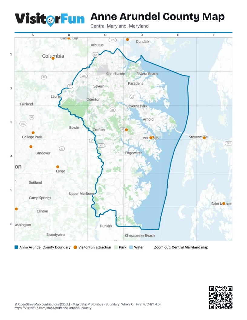
Street index of Anne Arundel County
Each street on the sheet and the grid squares it crosses.
- Paul T. Pitcher Memorial HighwayB1, C2, D2
- Arundel ExpresswayC1, C2, D2
- Baltimore BeltwayC1, D1
- Baltimore-Washington ParkwayC1, B2, B3
- Harbor Tunnel ThroughwayC1
- Harbor Tunnel ThruwayC1
- Metropolitan BoulevardC1
- Patuxent FreewayB2, C2, C3
- John Hanson HighwayC3, D3, C4
- Robert Crain HighwayC3
- Aris T Allen BoulevardD3, D4
- Blue Star Memorial HighwayD3, E3
- Chesapeake Bay BridgeE3
- Southern Maryland BoulevardC5
- Stephanie Roper HighwayC5
Things to do on the Anne Arundel County map
Places on the map
- Airport 100
- Airport Square Technology Park
- Amtrak
- Annapolis
- Annapolis Neck
- Annapolis Seaplane Base
- Anne Arundel County
- Anne Arundel County Fair Site
- Anne Arundell Manor
- Arden on the Severn
- Arnold
- Arundel Overlook
- Arundel View
- Bacon Ridge Natural Area
- Baltimore & Annapolis Trail
- Baltimore-Washington International/Thurgood Marshall Airport
- Bay Hills Golf Club
- Bay Meadow
- Bell Branch Park
- Bodkin Creek
- Boulevard Park
- Brandon Woods Business Park
- Brittingham
- Broad Creek Park
- Broadwater Creek
- Brooklyn Park
- Buckeye Terminals
- BWI Rental Car Facility
- BWI Tech Park
- Camp Letts
- Cape St. Claire
- Carrs Creek
- Chartwell Country Club
- Compass Point Golf Course
- Cox Creek
- Cox Creek/Swan Creek Wetland
- Creekside Village
- Creekstone Village
- Crofton
- Crofton Country Club
Next to Anne Arundel County
- Arbutus
- Bowie
- Brandywine
- Calverton
- Camp Springs
- Chesapeake Beach
- Clinton
- College Park
- Columbia
- Dundalk
- Dunkirk
- Ellicott City
- Fairland
- Forestville
- Fort Washington
- Greenbelt
- Hyattsville
- Landover
- Largo
- Laurel
- North Beach
- Oxon Hill
- Saint Michaels
- Stevensville
- Suitland
- Upper Marlboro
- White Oak
© OpenStreetMap contributors (ODbL) · Map data: Protomaps · Boundary: Who's On First (CC-BY 4.0)