

Maryland map
Frederick map
About 89,537 people live here (Census Bureau, 2024 estimate). The sheet's index lists 300 streets; Monocacy Boulevard, Frederick Freeway and West Patrick Street cross the most grid squares. Things to do inside the boundary: Heart of the Civil War Heritage Area, National Museum of Civil War Medicine and Weinberg Center for the Arts.
Open the map (PDF, US Letter)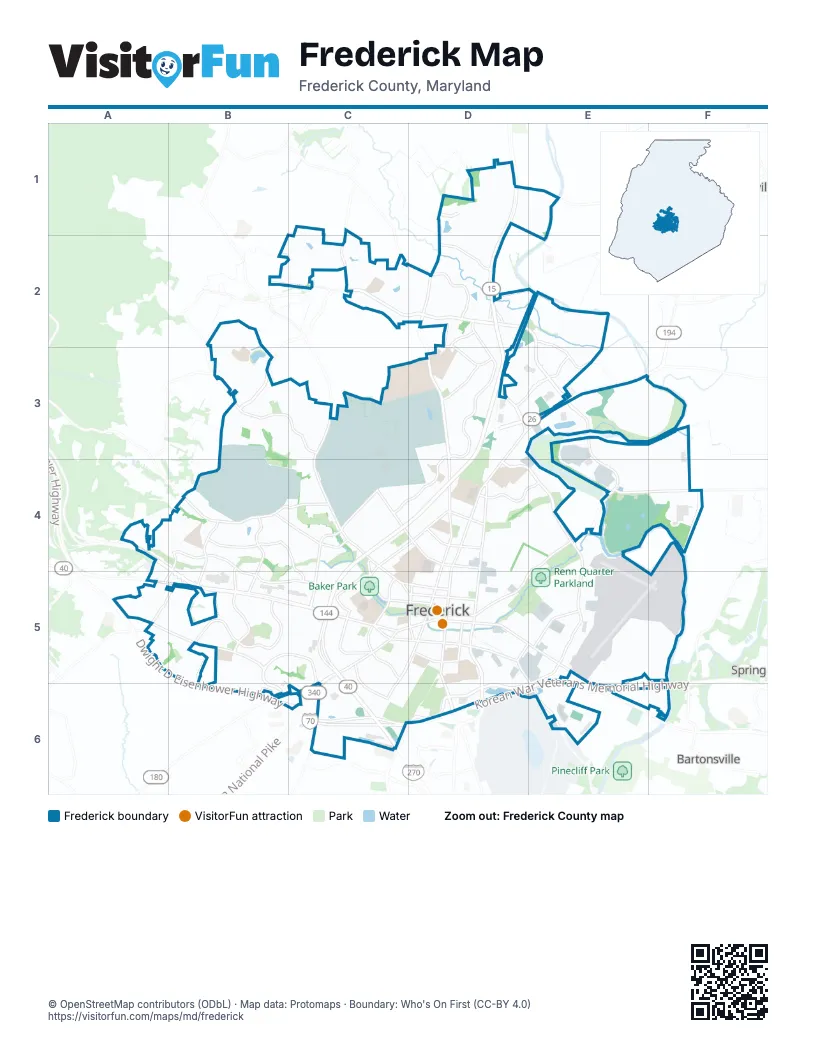
Street index of Frederick
Each street on the sheet and the grid squares it crosses.
- Frederick FreewayD3, C4, D4, C5, C6
- Catoctin Mountain HighwayD1, D2, D3
- Korean War Veterans Memorial HighwayE5, C6, D6, E6
- Dwight D Eisenhower HighwayB6, C6
- Jefferson National PikeC5, C6
- Eisenhower Memorial HighwayC6
- West Patrick StreetA4, B4, B5, C5, D5
- North Market StreetD3, E3, D4, D5
- East StreetD4, D5, D6
- East Patrick StreetD5, E5, E6
- Liberty RoadD3, E3
- South Market StreetD5, D6
- East South StreetD5, E5, E6
- South Jefferson StreetC5
- North Bentz StreetD4, D5
- Motter AvenueD4
- West South StreetC5, D5
- Bowmans Farm RoadE5, F5, E6
- West 9th StreetC4, D4
- Baltimore National PikeA4
- Old National PikeA5, B5
- Buckeystown PikeD6
- South East StreetD5
- South Bentz StreetD5
- Routzahn WayD3
- Monocacy BoulevardD2, E2, E3, E4, E5, D6, E6
- Christophers CrossingC2, D2, B3
- Opossumtown PikeD2, D3, D4
- Schifferstadt BoulevardD4, E4
- East Church StreetE4, D5, E5
- Rosemont AvenueC4, C5
- West 7th StreetC4, D4
- Baughmans LaneC4, C5
- New Design RoadD6
- Gas House PikeE4, F4
- Yellow Springs RoadC3, C4
- Dill AvenueC5, D5
- East 7th StreetD4, D5
- Everly DriveE3
- Jefferson PikeC6
- North East StreetD5
- Ballenger Creek PikeC6
- Franklin StreetD5, E5
- West 3rd StreetD5
- West 4th StreetD5
- Shookstown RoadB4, C4
- Thomas Johnson DriveD2, D3
- Butterfly LaneA5, B5, C6
- Rocky Springs RoadB3, B4, C4
- Fairview AvenueC4, D4, C5
- Hillcrest DriveB5
- Key ParkwayB4, B5, C5
- Himes AvenueB5, C5, B6, C6
- Schaffer DriveB4, C4
- Taney AvenueD3, C4, D4
- Mill Pond RoadD3, E3
- West 2nd StreetC4, C5, D5
- Center StreetC5, D5, C6
- Hayward RoadD2, D3
- Tuscanny DriveB3, C3
- Willowdale DriveB4, B5
- Waterside DriveE2, E3
- Catoctin AvenueC5, D5
- McClellan DriveD2
- Bel Aire LaneB4, C4, C5
- South McCain DriveB5
- Old Camp RoadB4, A5
- East 16th StreetD4, E4
- Prospect BoulevardC5, C6
- Waverley DriveB4, B5
- South Carroll StreetD5
- Wormans Mill RoadD3
- Crown Point DriveD1
- Hughes Ford RoadE5
- Willow RoadD2
- Montevue LaneB4, C4
- Amber DriveD3
- East 9th StreetD4
- College AvenueD5
- Kemp LaneB3, B4
- Military RoadC4
- West College TerraceC5
- Mount Phillip RoadA5, B5
- Madison StreetC5, D5
- Walter Martz RoadC2
- Kline BoulevardC5
- East 3rd StreetD5
- Willowbrook RoadD1, D2
- Reichs Ford RoadE6
- Bowers RoadA4, B4
- Rockwell TerraceC5, D5
- Norva AvenueC5
- Biggs Ford RoadD1, E1
- North McCain DriveB4, B5
- Braddock AvenueC5
- Byte DriveD2
- West 13th StreetD4
- Blentlinger RoadA4, A5
- Clarke PlaceD5
- Monroe AvenueE5
- West Church StreetD5
- East 13th StreetD4
- Degrange StreetD5
- North College ParkwayC5, D5
- Porter StreetC3, D3, C4
- Wheyfield DriveE3, F3
- Progress DriveE4, F4
- Base RoadB3, B4
- Tilco DriveE6
- Chamberlain DriveC1, C2
- Ditto AvenueC3, C4
- Wilson PlaceC4, D4
- Mill Island ParkwayE2, E3
- Doughten DriveC3, C4
- Holden RoadD4, E4, D5
- Hill StreetB5
- Wyngate DriveC5
- East Willow RoadD1, D2
- Ensemble WayE5
- Veterans DriveC4
- Beasley DriveC4
- Maxwell AvenueD4, D5
- Carroll ParkwayC5, D5
- Carrollton DriveC5, D5, C6
- Waterford DriveC4, C5
- Controller CourtE5, F5
- Andover LaneA4, B4
- Bear Den RoadE3
- West Greenleaf DriveB2, B3
- Pine AvenueD4, D5
- Union StreetE4, E5
- Pearson BoulevardD1, D2
- Island Grove BoulevardE2
- Bucheimer RoadE5
- Magnolia AvenueC4, D4, C5
- Logan StreetC5, D5, D6
- Heather Ridge DriveD3, D4
- Mill Race RoadE2
- Old Farm DriveC3
- Whittier DriveB3
- Osprey WayD3, E3
- Highland StreetD5, E5
- Lee PlaceC4
- Ricketts RoadB2, C2
- Ballenger Center DriveC6
- Nalin Farm Pond RoadD3
- Stadium DriveD5, D6
- East 5th StreetD5
- Wetherburne WayB2, B3
- Dogwood DriveD4, E4
- East Greenleaf DriveB3
- Tuscarora Creek BoulevardC2
- Bond StreetE5
- Moran DriveC2, D2
- Grant PlaceC4
- Pearl StreetC5, C6
- Aviation WayE5
- East 4th StreetD5
- Campus DriveC3, D3
- West 12th StreetC4, D4
- Bishops Glen DriveB4
- Chapel AlleyD4, D5
- Biggs AvenueC4
- Contender WayB5
- Riverwalk PlaceF4
- Carroll Walk AvenueE4, E5
- Castle Rock RoadE3, F3
- Rock Creek DriveA4, C4
- Schley AvenueC4
- William Franklin DriveD2
- Infantry DriveB2, C2
- Swallowtail DriveB5
- Evergreen AvenueC4, C5
- Delaware RoadD4
- Thomas AvenueC5
- Young PlaceC4, D4
- Monocacy Ford RoadE2
- Orchard WayB5
- Monarch Ridge RoadA5
- Stark StreetC3, C4
- First Flight CourtC3
- Foundry StreetE5
- Cobblestone WayB3
- Dearbought DriveE3, F3
- Chestnut LaneB3, C3
- Saxton DriveC2
- Carrier LaneC6
- Blacksmith WayB4
- Research DriveC5, C6
- Rose LaneD4
- Sultan StreetC4
- Cohasset CourtB3
- Algonquin RoadE3
- Miller DriveC4
- East 2nd StreetD5
- Burnside DriveD2
- Amber Meadow DriveC3
- Linden AvenueC5
- Millstream DriveD3
- Crops WayC3
- Stonegate DriveB4
- West 5th StreetD5
- Furgeson LaneB4
- Reservoir AlleyC4, D4
- Lake Coventry DriveB4
- Broadband DriveE3, E4
- Trail AvenueD4, D5
- Misty Meadows CircleB4
- Harpers WayD2
- Hunting Horn LaneB5
- West 14th StreetD4
- Boyles StreetC4
- Fieldpointe BoulevardC6, D6
- Lakeside DriveB2
- Belmont AvenueC4
- Angelwing LaneA5
- Chandler StreetC4
- Bushytail DriveB5
- Scholls LaneC5, D5
- Pontiac AvenueD4
- Mount Olivet BoulevardD5
- Fairfield DriveD3
- Selwyn PlaceD4
- Pinewood DriveD4
- Freedman DriveC3, C4, D4
- Willowcrest DriveB4
- Hanson StreetE5
- Treatment Plant RoadE4
- Jubal WayE2
- Apple AvenueC4
- Herringbone WayE5
- McClellan AlleyC5, D5
- Riverbend WayE3
- Independence StreetB3
- Wormans Mill CourtD3
- Eagle Rock LaneB3, C3
- Carriage WayD3
- Lindley RoadD4, E4, D5
- Atlas DriveC4
- Branca DriveC3
- Bristol DriveC3
- Willow AvenueC5, C6
- Crosstimber WayD2
- Geronimo DriveD4
- Shorebird StreetD3, E3
- Airport Drive EastE5, E6
- Wren AlleyB2
- Synergy WayF4
- Shawnee DriveD4
- Spires WayE4
- Goose Creek WayC3
- Solarex CourtC6
- Heathfield DriveB4
- 5 Shillings RoadE3
- Cawley DriveC6
- Shelly CircleB3
- Rollinghouse DriveB5
- East 6th StreetD5
- Culler AvenueC4
- Wood StreetC4
- Mercer PlaceC5
- Locust AvenueC5
- Doctor Bourne DriveC4
- Acropolis WayB5, C5, C6
- Alessandra CourtC5
- Mews LaneD4
- Tiller StreetE5
- Grove Hill RoadB5
- Laurel Wood WayE3
- Broadway StreetD5
- Midsummer DriveD2
- Wilmer Park LaneB5
- Egret WayD3
- Eisenhower DriveC5
- Lindfield DriveB4
- Timber Grove RoadD2
- Precision WayE4
- Windview WayC6
- Mohican DriveE4
- Thames DriveB4
- Carrington WayB3
- Carroll Creek View CourtB3, C3
- East All Saints StreetD5
- Wainwright CourtC3
- Baker Place WestB4
- Burck StreetC5
- Grove AlleyC4, C5
- Bexhill DriveB4
- Upper College TerraceC5
- Heather LaneD3
- Old Gas House PikeE4, D5, E5
- Lawnview DriveD3
- Hampshire DriveB4
- Dulaney Mill DriveC4, C5
- Pemberton Park LaneA5, B5
- Palatine DriveE2
- Pennsylvania AvenueD5
- Brook Valley RoadE2
- Harvest DriveD3
- Trafalgar LaneE3
Things to do on the Frederick map
Places on the map
- Amber Meadows Shopping Center
- Baker Park
- Benton Track
- Carroll Creek Park
- Centerpark Medical & Professional Center
- Citizens Ballroom
- Clemson Corner
- Clerestory Park
- Clustered Spires Golf Course
- College Park Plaza
- Culler Lake
- District 40
- Fairview Cemetery
- FedEx Ship Center
- Festival at Frederick
- Fort Detrick
- Frederick County Public Library
- Frederick County Square
- Frederick Fairgrounds
- Frederick Health Hospital
- Frederick Municipal Airport
- Frederick Shoppers World
- Frederick Shopping Center
- Fredericktowne Village Park
- Golden Mile Market Place
- Governor Thomas Johnson High School
- Husky Park
- Loats Park
- Market Square of Frederick
- Mount Olivet Cemetery
- Prospect Plaza
- Renn Quarter Parkland
- Rivermist Park (City Of Frederick)
- Riverside Center
- Rose Hill Manor Park
- The Shops at Monocacy
- Vista Shops
- Walnut Ridge Park
- Westridge
Next to Frederick
- Bartonsville
- Spring Ridge
- Walkersville
© OpenStreetMap contributors, Open Database License, openstreetmap.org/copyright · Map data: Protomaps · Boundary: Who's On First (CC-BY 4.0); Quattroshapes (CC BY 2.0)















