

Maryland map
Hyattsville map
About 21,052 people live here (Census Bureau, 2024 estimate). The sheet's index lists 139 streets; 42nd Avenue, Nicholson Street and Longfellow Street cross the most grid squares. Things to do inside the boundary: Anacostia Trails Heritage Area.
Open the map (PDF, US Letter)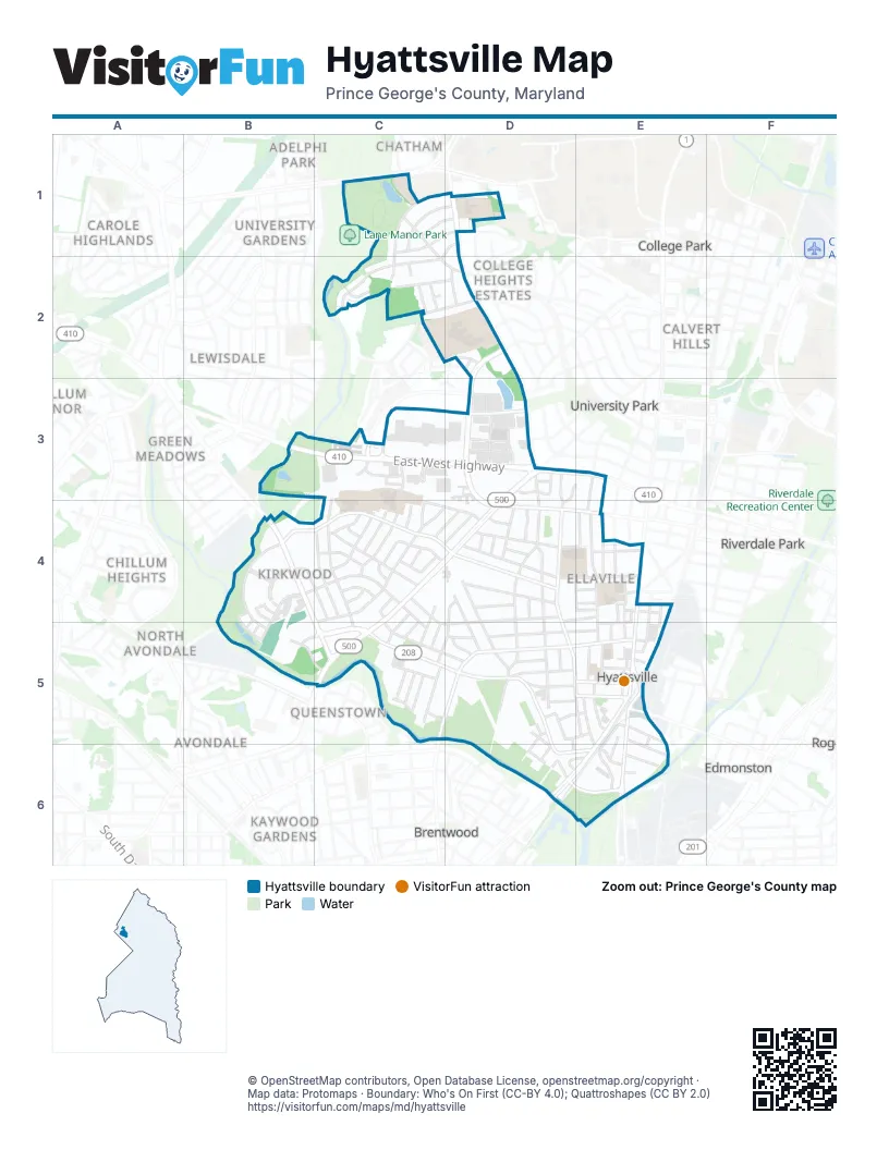
Street index of Hyattsville
Each street on the sheet and the grid squares it crosses.
- Pennsylvania StreetC1, D1
- Purdue StreetC1, D1
- Rutgers StreetC1, D1
- Stanford StreetC1, C2
- Tulane DriveC1
- University Boulevard EastC1
- Wells BoulevardC1, C2
- Adelphi RoadD1, D2, D3
- Notre Dame StreetD1, C2
- Bridle Path LaneC2
- Calverton DriveC2, D2
- Gumwood DriveC2
- Hitching Post LaneC2
- Pony Trail CourtC2
- Pony Trail LaneC2
- Rosemary LaneC2, D2
- Wells ParkwayC2, D2
- Belcrest RoadD2, D3, D4
- Carnaby StreetD2
- Claymore AvenueD2
- Kona WayD2
- Spurrier LaneD2
- Stella Blue DriveD2
- Tebow LaneD2
- Van Buren StreetD2
- East-West HighwayB3, C3, D3, E3
- 31st AvenueC3, C4, C5
- Editors Park DriveC3
- Enquirer StreetC3
- Gazette WayC3
- Herald StreetC3
- Journal StreetC3
- Monitor StreetC3
- Observer WayC3
- Prince George's PlazaC3
- Sentinel DriveC3
- Toledo RoadC3, D3
- Toledo TerraceC3, D3
- 41st AvenueD3, D4, D5
- 41st PlaceD3, D5, D6
- 42nd AvenueD3, D4, D5, E5, D6
- America BoulevardD3
- Carrollton TerraceD3, E3, D4
- Constitution DriveD3
- Democracy AvenueD3
- Freedom Way EastD3
- Freedom Way WestD3
- Liberty Lane EastD3
- Liberty Lane WestD3
- Melville StreetD3
- Queens Chapel RoadD3, C4, D4, C5
- Quintana StreetD3
- Roanoke RoadD3
- Tennyson RoadD3
- 43rd AvenueE3, E4, E5
- 29th AvenueB4, C4
- Ager RoadB4, C5
- Crimson Fox DriveB4
- Elkhorn AlleyB4, B5
- Emerald Branch DriveB4
- Hush AlleyB4
- Hyattsville DriveB4, B5
- Kirkwood PlaceB4
- Lancer DriveB4, C4, C5
- Little Branch RunB4, B5
- Nicholson StreetB4, C4, D4, E4, B5
- River Terrace RoadB4, B5
- Spring AlleyB4, B5
- Still AlleyB4
- The MallB4
- Whisper AlleyB4
- Winter AlleyB4
- 30th AvenueC4
- 31st PlaceC4
- 32nd AvenueC4
- 33rd AvenueC4
- 33rd PlaceC4
- 34th AvenueC4
- 35th AvenueC4, C5
- 35th PlaceC4, C5
- 36th AvenueC4, D4, C5
- 37th AvenueC4, D4, C5, D5
- Hamilton Manor DriveC4
- Jamestown RoadC4, D4, B5, C5
- Kelliher RoadC4
- Kimberly RoadC4
- Lancer PlaceC4
- Longfellow StreetC4, D4, E4, C5, D5
- Madison PlaceC4
- Madison StreetC4, D4, E4
- Manorwood DriveC4
- Maryhurst DriveC4
- Oliver StreetC4, D4, E4
- 38th PlaceD4
- 38th StreetD4, C5, D5
- 39th AvenueD4, D5
- 39th PlaceD4
- 40th AvenueD4, D5, D6
- 40th PlaceD4, D5, D6
- Livingston StreetD4
- Oglethorpe StreetD4, E4
- Oneida PlaceD4
- Powhatan RoadD4
- Queensbury RoadD4, E4
- 42nd PlaceE4, E5, E6
- 43rd StreetE4
- 44th AvenueE4, E5, E6
- 45th AvenueE4, E5
- 46th PlaceE4, E5
- Baltimore AvenueE4, E5, E6
- Kennedy StreetE4, D5, E5
- Lustine StreetE4, E5
- Maccaboy StreetE4
- Alpha Ridge AvenueB5
- Hamilton StreetB5, C5, D5, E5
- Quiet AlleyB5
- Summer AlleyB5
- 36th PlaceC5
- 37th PlaceC5
- Farragut StreetC5, D5, E5
- Gaines AlleyC5
- Gallatin StreetC5, D5, E5
- Jefferson StreetC5, D5, E5
- Crittenden StreetD5, D6, E6
- Decatur StreetD5, E5
- Emerson StreetD5, E5
- Ingraham StreetD5
- Kennedy PlaceD5
- 43rd PlaceE5
- 46th AvenueE5, E6
- Burlington RoadE5, E6
- Church PlaceE5
- Rhode Island AvenueE5, D6, E6
- 41st StreetD6
- Banner StreetD6
- Braxton PlaceD6, E6
- Buchanan StreetD6, E6
- Charles Armentrout DriveD6, E6
- Arundel PlaceE6
Things to do on the Hyattsville map
Places on the map
- 38th Avenue Neighborhood Park
- 7-Eleven
- Aldi
- AutoZone
- Bank of America
- Bestway
- Capital One
- Crossover Church
- CVS Pharmacy
- David C. Driskell Community Park
- DeMatha Catholic High School
- Edward M. Felegy Elementary
- First United Methodist Church
- Giant
- Hamilton Park
- Heurich Community Park
- Heurich Dog Park
- Home Depot
- Home Theatres Regal Hyattsville Royale Regal Hyattsville Royale
- Hyatt Park
- Hyatt Park Community Garden
- Hyattsville Branch
- Hyattsville City Hall
- Hyattsville District Court Building
- Hyattsville Elementary School
- Hyattsville Fire Station Company 1
- Hyattsville Mennonite Church
- Hyattsville Middle School
- Kirkwood Park
- Northwestern High School
- Orem Middle School
- The Mall at Prince Georges
- University Hills Park
- USPS Prince Georges Plaza
Next to Hyattsville
- Adelphi Park
- Avondale
- Avondale Terrace
- Brentwood
- Brookside Manor
- Calvert Hills
- Carole Highlands
- Chatham
- Chillum Heights
- Chillum Manor
- College Heights
- College Heights Estates
- College Park map
- Edmonston
- Green Manor
- Green Meadows
- Kaywood Gardens
- Lewisdale
- Lord Calvert Manor
- Michigan Park Hills
- North Avondale
- North Brentwood
- North Woodridge
- Old Town
- Queenstown
- Riverdale Park
- Riverdale Park Station
- University Gardens
- University Park
- West Riverdale
- Whiteley
© OpenStreetMap contributors, Open Database License, openstreetmap.org/copyright · Map data: Protomaps · Boundary: Who's On First (CC-BY 4.0); Quattroshapes (CC BY 2.0)















