

Maryland road map
I-495 in Maryland map
I-495 is about 39 miles in Maryland. It has 51 exits, from Exit 41 at mile 0 to Exit 2A-B at mile 39. It meets 27 highways; MD 193, I-95 and MD 190 meet it in the most grid squares.
Open the map (PDF, US Letter)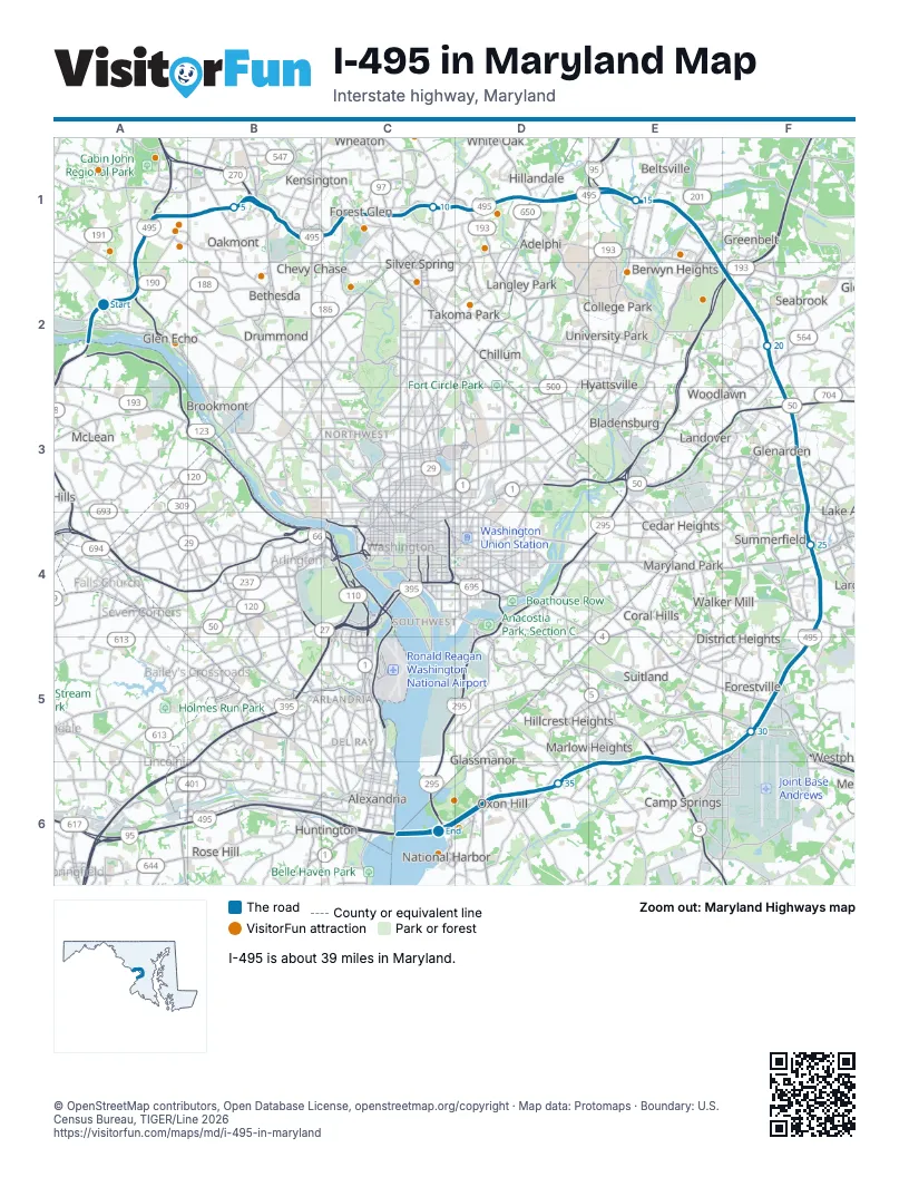
Exits on I-495 in Maryland
Each exit in mile order, with its grid square.
- Exit 41mile 0, A2
- Exit 40mile 2, A2
- Exit 39mile 2, A2
- Exit 38mile 3, A1
- Exit 36mile 5, B1
- Exit 34mile 5, B1
- Exit 35mile 6, B1
- Exit 33mile 7, B1
- Exit 31Bmile 9, C1
- Exit 31Amile 9, C1
- Exit 31mile 9, C1
- Exit 30Bmile 10, C1
- Exit 30Amile 10, C1
- Exit 30mile 10, C1
- Exit 29mile 11, D1
- Exit 28Bmile 12, D1
- Exit 28Amile 13, D1
- Exit 27mile 13, D1
- Exit 25B-Amile 14, E1
- Exit 25mile 16, E1
- Exit 24mile 16, E1
- Exit 23mile 18, F2
- Exit 22Bmile 18, F2
- Exit 22Amile 19, F2
- Exit 20B-Amile 20, F2
- Exit 20Bmile 21, F2
- Exit 20Amile 21, F2
- Exit 19Amile 21, F2
- Exit 19Bmile 21, F2
- Exit 17-16mile 23, F3
- Exit 16mile 25, F4
- Exit 15Bmile 25, F4
- Exit 15Amile 26, F4
- Exit 15mile 26, F4
- Exit 13mile 27, F4
- Exit 11Bmile 29, F5
- Exit 11Amile 30, F5
- Exit 9mile 30, F5
- Exit 7A/7Bmile 33, E6
- Exit 7Bmile 33, E6
- Exit 7Amile 33, E6
- Exit 4Bmile 35, D6
- Exit 4Amile 36, D6
- Exit 3Bmile 37, D6
- Exit 2Bmile 38, C6
- Exit 1Amile 38, C6
- Exit 2Amile 38, C6
- Exit 1Bmile 38, C6
- Exit 3Amile 39, C6
- Exit 3mile 39, C6
- Exit 2A-Bmile 39, C6
Highways I-495 meets
Each highway it meets and the grid squares where they meet.
- MD 190A2
- I-270A1
- MD 191A1
- MD 187B1
- MD 355B1
- MD 185B1
- MD 192C1
- MD 97C1
- US 29C1
- MD 193D1, F2
- MD 650D1
- MD 212D1
- I-95E1, E5
- US 1E1
- MD 201E1
- MD 295F2
- MD 450F2
- I-595F3
- US 50F3
- MD 704F3
- MD 202F3
- MD 214F4
- MD 4F5
- MD 5E6
- MD 535E6
- MD 414D6
- MD 210D6
Towns along I-495 in Maryland
In mile order, with the grid square of each.
- Potomacmile 0, A2
- Cabin Johnmile 0, A2
- Bethesdamile 1, A2
- North Bethesdamile 4, B1
- South Kensingtonmile 6, B1
- Kensingtonmile 7, B1
- Chevy Chasemile 7, B1
- Silver Springmile 8, C1
- Wheatonmile 9, C1
- Forest Glenmile 9, C1
- Kemp Millmile 10, C1
- Four Cornersmile 10, C1
- Burnt Millsmile 11, D1
- Adelphimile 12, D1
- White Oakmile 12, D1
- Hillandalemile 13, D1
- Calvertonmile 13, D1
- Beltsvillemile 14, E1
- College Parkmile 14, E1
- Greenbeltmile 16, E1
- Berwyn Heightsmile 17, E1
- Seabrookmile 19, F2
- New Carrolltonmile 19, F2
- Lanhammile 20, F2
- Springdalemile 22, F3
- Landovermile 22, F3
- Glenardenmile 23, F3
- Lake Arbormile 23, F3
- Summerfieldmile 24, F3
- Ketteringmile 25, F4
- Largomile 26, F4
- Walker Millmile 26, F4
- Forestvillemile 27, F4
- Brown Stationmile 27, F4
- Westphaliamile 28, F5
- Andrews AFBmile 30, F5
- Suitlandmile 30, F5
- Morningsidemile 31, E5
- Camp Springsmile 31, E5
- Silver Hillmile 33, E6
- Marlow Heightsmile 34, E6
- Temple Hillsmile 34, E6
- Hillcrest Heightsmile 34, E6
- Oxon Hillmile 35, D6
- Glassmanormile 35, D6
- Forest Heightsmile 37, D6
- National Harbormile 38, C6
- Fort Washingtonmile 39, C6
Things to do on the I-495 in Maryland map
© OpenStreetMap contributors, Open Database License, openstreetmap.org/copyright · Map data: Protomaps · Boundary: U.S. Census Bureau, TIGER/Line 2026















