

Maryland map
National Harbor map
The sheet's index lists 89 streets; Oxon Hill Road, Capital Beltway (Local) and Capital Beltway (Thru) cross the most grid squares. Also on it: AC Hotel by Marriott National Harbor Washington, DC Area, Addison School and Adidas. Just past the edge: Brooke Manor, Hunts Corner and Murray Hill.
Open the map (PDF, US Letter)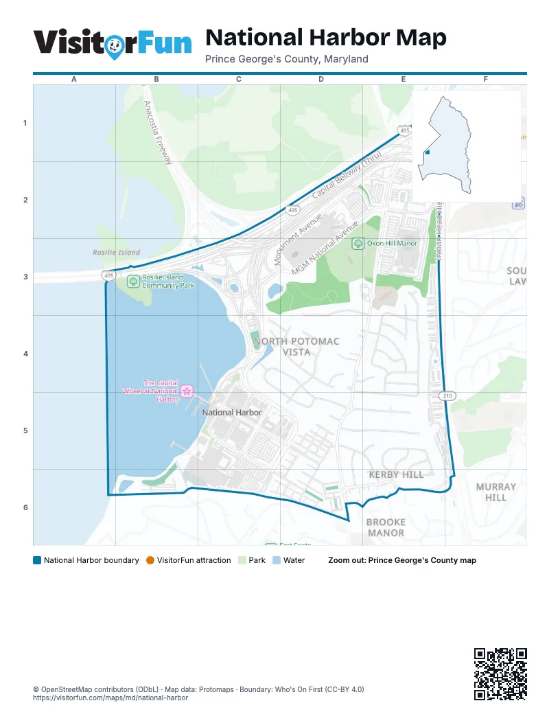
Street index of National Harbor
Each street on the sheet and the grid squares it crosses.
- Bald Eagle RoadE1
- Capital Beltway (Local)E1, C2, D2, A3, B3, C3
- Capital Beltway (Thru)E1, C2, D2, A3, B3, C3
- Indian Head HighwayE1, E2, E3, E4, F5, F6
- Oxon Hill RoadE1, E2, E3, D4, E4, D5, D6
- MGM National AvenueD2, E2, C3, D3
- Monument AvenueD2, E2, C3, D3
- Tanger BoulevardE2
- Woodrow Wilson Memorial Bridge (Local)A3
- Anacostia FreewayC3
- National Harbor BoulevardC3, C4, C5, D5, B6, C6
- North Cove TerraceC3, C4
- Balmoral Drive EastD3, E3, D4
- Abbington DriveE3, D4, E4, D5, E5
- Abbington PlaceE3
- Cloverdale DriveE3, E4
- Dominion DriveE3, E4
- Wilson Bridge DriveE3, E4, E5
- Alexandria DriveC4, D4
- Balmoral Drive WestC4, D4
- Mel Mara DriveC4, D4
- National PlazaC4, C5
- Panorama CourtC4
- Panorama DriveC4, D4, D5
- Waterfront StreetC4, C5, C6, D6
- Alexandria Overlook DriveD4
- Appletree LaneD4, E4
- Loureiro LaneD4, E4
- Overlook CourtD4
- Pipers Glen LaneD4, E4
- Riverhill RoadD4, D5
- Brockton RoadE4
- Ellsworth PlaceE4
- Ferndale PlaceE4
- Gibson DriveE4, E5
- Hayworth PlaceE4
- American WayC5, D5
- Fleet StreetC5
- Mariner PassageC5
- Potomac PassageC5
- Riverhaven DriveC5, D5
- Saint George BoulevardC5
- Waterman PassageC5
- Careybrook LaneD5, E5
- Catamaran WayD5
- Cedar Ridge DriveD5, E5
- Claudia DriveD5, E5, E6
- Cutter PlaceD5
- Esther DriveD5, D6
- Hallard LaneD5, D6
- Halsey WayD5
- Harbor Port WayD5
- Harborview DriveD5, D6
- Leigh WayD5
- Marina View WayD5
- Reef WayD5
- Rivermount PlaceD5, D6
- Riversail LaneD5
- Silver Clipper LaneD5
- Skiff WayD5, D6
- Triggerfish DriveD5
- Trimaran WayD5
- Vista TerraceD5
- Windboard WayD5
- Corla DriveE5
- Elroy PlaceE5, E6
- Indian Head Highway Service RoadE5, F5, E6, F6
- Sandy PlaceE5, E6
- Winslow RoadE5, E6
- National Harbour BoulevardB6
- Overlook Park DriveC6, D6
- Rampart WayC6, D6
- Spindrift LaneC6, D6
- Windlass WayC6, D6
- Admirals WayD6
- Fair Winds WayD6
- Kerby Hill RoadD6, E6, F6
- Kerby ParkwayD6
- Quayside CourtD6
- Regents SquareD6
- River Mist DriveD6
- Sentry SquareD6
- Sprintsail WayD6
- Topmast DriveD6
- Wellfleet DriveD6
- Windward WayD6
- Aragona DriveE6
- Barrymore DriveE6
- Gina CourtE6
Places on the map
- AC Hotel by Marriott National Harbor Washington, DC Area
- Addison School
- Adidas
- AMERICA!
- American Market at National Harbor
- APlus
- Arts’tination
- Ase Water
- Banana Republic
- Bar Silver
- Bellagio Patisseri
- Ben & Jerry's
- Betty Blume Park
- Blossom
- Bobby McKey's
- Bobby McKey's Dueling Piano Bar
- Bombay Street Food
- Bond 45
- Bread + Butter
- Brooks Brothers
- Brother Jimmy's BBQ
- Build-A-Bear Workshop
- BurgerFi
- Cadillac Ranch Grill
- Cake Love
- Calvin Klein
- Carter's
- ChargePoint
- Chico's
- Chipotle
- claire's
- Club Wyndham National Harbor
- Coach
- Cole Haan
- Columbia
- Comfort One Shoes
- Convention Center Loading Dock
- CVS Pharmacy
- Diablo's Cantina
Next to National Harbor
- Brooke Manor
- Hunts Corner
- Murray Hill
- South Lawn
© OpenStreetMap contributors (ODbL) · Map data: Protomaps · Boundary: Who's On First (CC-BY 4.0)