

Minnesota map
Anoka County map
About 376,840 people live here (Census Bureau, 2024 estimate). The sheet's index lists 69 streets; Lake Drive Northeast, Saint Francis Boulevard and Viking Boulevard Northeast cross the most grid squares. Things to do inside the boundary: Running Aces Casino, Hotel & Racetrack.
Open the map (PDF, US Letter)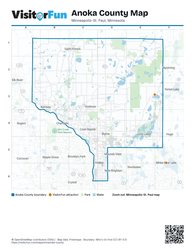
Street index of Anoka County
Each street on the sheet and the grid squares it crosses.
- Saint Francis BoulevardB1, B2, B3, B4
- St Francis BoulevardB1, C1
- 229th Avenue NorthwestC1
- Ambassador Boulevard NorthwestC1
- Bridge Street NorthwestC1
- Bridge Street Northwest/Lake George Boulevard Northwest Traffic CircleC1
- Bridge Street Northwest/Poppy Street/Rum River Boulevard Northwest Traffic CircleC1
- Lake George Boulevard NorthwestC1, C2
- University Avenue Extended NortheastC1, D1
- 237th Avenue NortheastD1
- 181st Avenue NorthwestA2
- Baugh Street NorthwestA2, A3
- Viking Boulevard NorthwestA2, B2, C2
- Cedar Drive NorthwestC2
- Flamingo Street NorthwestC2
- Hanson Boulevard NorthwestC2, C3, C4
- Round Lake Boulevard NorthwestC2, C3, C4
- Viking Boulevard NortheastC2, D2, E2, F2
- 181st Avenue NortheastD2
- 187th Lane NortheastD2
- Baltimore Street NortheastD2
- Kettle River Boulevard NortheastF2, E3, F3
- Armstrong Boulevard NorthwestA3, B3
- Bunker Lake BoulevardB3, C3, B4, C4
- Riverdale Drive NorthwestB3
- 161st Avenue NorthwestC3
- Crosstown Boulevard NorthwestC3, D3
- Crosstown Boulevard NortheastD3, E3
- Lexington Avenue NortheastD3, E3, D4, D5
- Lake Drive NortheastE3, F3, E4, D5, E5
- West Broadway AvenueE3, F3
- 5th AvenueB4
- Coon Rapids Boulevard NorthwestB4, C4, C5
- East Main StreetB4, C4
- East River RoadB4, C5, C6
- Greenhaven RoadB4
- North Ferry StreetB4
- South Ferry StreetB4
- Thurston AvenueB4
- Voyageur HighwayB4
- West Main StreetB4
- 109th Avenue NortheastC4, D4
- Bunker Lake Boulevard NortheastC4, D4
- Bunker Lake Boulevard NorthwestC4, D4
- Foley BoulevardC4, C5
- Main Street NortheastC4, D4, E4
- Main Street NorthwestC4
- Northdale Boulevard NorthwestC4
- University Avenue NortheastC4, C5, D5, D6
- University Avenue NorthwestC4
- 125th Avenue NortheastD4
- Central Avenue NortheastD4, D5, D6
- Radisson Road NortheastD4, D5
- Centerville RoadE4, E5
- Main StreetE4, F4
- Frenchman Road NorthF4
- 101st Avenue NorthwestC5
- County Highway 10C5, D5
- MN-610C5, D5
- 95th Avenue NortheastD5
- Highway 65D5, D6
- Lexington Avenue NorthD5
- Lovell Road NortheastD5
- Mounds View BoulevardD5
- State Hwy 65 Service RoadD5
- Birch StreetE5
- Hodgson RoadE5
- Highway 65 NortheastD6
- Northeast University AvenueD6
Things to do on the Anoka County map
Places on the map
- Al Flynn Park
- Alpine Acres Townhomes
- Alpine Park
- Amelia Lake
- Anderson Lake
- Andover
- Anoka
- Anoka County
- Anoka County Fairgrounds
- Anoka County-Blaine Airport
- Anoka Nature Preserve
- Anoka Senior High
- Anoka-Metro Regional Treatment Center
- Anoka-Ramsey Landfill
- Anoka-Ramsey Natural Area
- Aquatore Park
- Aspen Bay
- Aspen Woods
- Baldwin Lake
- Baldwin Park
- Baseball Complex
- Bass Lake
- Bear Lake
- Benjamin Lake
- Bethel
- Bethel Wildlife Management Area
- Birchwood Arces Park
- Blaine
- Blaine High School
- Blaine Soccer Fields
- Blaine Wetland Sanctuary
- Boot Lake
- Boot Lake Scientific and Natural Area
- Bunker Hills Disc Golf Course
- Bunker Hills Executive Course
- Bunker Hills Golf Course
- Bunker Hills Regional Park
- Bunker Lake
- Bunker Park Stables
- Burns Lake
Next to Anoka County
- Arden Hills
- Brooklyn Park
- Champlin
- Corcoran
- Crystal
- Elk River
- Forest Lake
- Hugo
- Mahtomedi
- Maple Grove
- Mounds View
- New Brighton
- New Hope
- Rogers
- Shoreview
- Vadnais Heights
- White Bear Lake
- Wyoming
© OpenStreetMap contributors (ODbL) · Map data: Protomaps · Boundary: Who's On First (CC-BY 4.0)