

Minnesota map
Edina map
About 53,564 people live here (Census Bureau, 2024 estimate). The sheet's index lists 300 streets; France Avenue South, Valley View Road and York Avenue South cross the most grid squares. Things to do inside the boundary: Southdale Center.
Open the map (PDF, US Letter)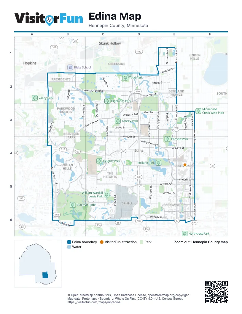
Street index of Edina
Each street on the sheet and the grid squares it crosses.
- Crosstown HighwayB4, C4, D4, E4, F4
- France Avenue SouthE1, E2, E3, E4, E5, E6
- Valley View RoadC4, D4, E4, B5, C5, E5
- Vernon AvenueD2, B3, C3, D3, B4
- West 66th StreetC4, D4, E4, F4
- Gleason RoadB3, B4, B5, C5, C6
- West 50th StreetD2, E2
- West 65th StreetD4, E4, F4
- Vernon Avenue / W 50th StD2
- York Avenue SouthF3, E4, F4, E5, E6, F6
- West 70th StreetC5, D5, E5, F5
- Normandale RoadD3, D4, D5, D6
- Wooddale AvenueD2, E2, E3, E4
- Interlachen BoulevardB2, C2, D2
- West 78th StreetB6, C6, E6, F6
- Xerxes AvenueF3, F4, F5, F6
- Tracy AvenueC3, C4, C5
- West 60th StreetC4, D4, E4
- Blake Road SouthB2, B3
- Lincoln DriveA2, B2, A3, B3, A4, B4
- West 76th StreetD6, E6
- Parklawn AvenueE6
- West 69th StreetC5, D5, E5, F5
- West 62nd StreetC4, D4, E4, F4
- West 58th StreetD3, E3, F3
- Halifax Avenue SouthE2, E3, E4
- Braemar BoulevardB5, C5, B6
- Benton AvenueC3, D3
- Cahill RoadC4, C5, C6
- McCauley Trail SouthB4, B5
- Concord AvenueD3, D4
- West 77th StreetD6, E6
- Indian Hills RoadB4
- Olinger BoulevardB3, C3, C4
- Hansen RoadC3, C4
- West Frontage RoadD2, D3
- Dewey Hill RoadC5, D5, C6
- Metro BoulevardD5, D6
- Maloney AvenueA2, B2
- Londonderry RoadA3, B3
- Ridgeview DriveC4, D4, D5
- Bush Lake RoadD5, C6, D6
- Eden AvenueD2, D3
- Drew Avenue SouthE3, E4
- Hazelton RoadE5
- West 44th StreetE1, D2, E2
- Brookside AvenueD2
- 44th Street WestE1, E2
- West 54th StreetE3
- Valley LaneC4
- Edina Industrial BoulevardD6
- Edinborough WayE6
- West 51st StreetD2, E2
- State Highway 169 Frontage RoadB5, B6
- Willson RoadD2, D3
- Antrim RoadC5
- West 49th StreetD2, E2
- Arcadia AvenueD2
- Southview LaneD3
- Normandale BoulevardD6
- Computer AvenueD6
- Viking DriveD6
- Minnesota DriveE6
- Forslin DriveC4, D4
- Indian Hills PassB4
- 7th Street SouthA2, B2
- Market StreetE2
- Grange RoadD2
- Gus Young LaneD2
- East Bush Lake RoadC6
- Link RoadD2
- Sunnyside AvenueE1
- West 64th StreetC4, D4, E4
- West Shore DriveD4, D5, D6
- West 56th StreetC3, D3, E3, F3
- Schaefer RoadB2, B3, B4
- Oaklawn AvenueE2, E3, E4, E5, E6
- Kellogg AvenueE2, E3, E4, E5, E6
- Sunnyside RoadE1, D2, E2
- Saint Johns AvenueD3, D4
- Grove StreetC3, D3
- Cornelia DriveE4, E5
- Brookview AvenueE3, E4
- Parkwood RoadB3
- Belmore LaneA2, B2
- Code AvenueD3, D4
- Chowen Avenue SouthE3, E4
- Malibu DriveB2, B3
- Grimes Avenue SouthE1, E2, E3, E4
- Beard Avenue SouthE3, E4
- Ayrshire BoulevardC3
- Lakeview DriveD3, E3
- West 59th StreetD3, E3
- Wooddale Avenue SouthD5, E5
- Zenith Avenue SouthE3, E4
- Ewing Avenue SouthE3, E4
- Tingdale AvenueD3, D4
- Mirror Lakes DriveC2, C3
- West 61st StreetC4, D4, E4, F4
- Abbott Avenue SouthE3, E4
- MerilaneC2
- Arden Avenue SouthE2
- Dunberry LaneD5, E5
- West 55th StreetE3, F3
- West 68th StreetC5, E5, F5
- Crescent DriveC3, C4
- Kelsey TerraceB2, B3
- Creek Valley RoadB4, C4, C5
- Shannon DriveC5, C6
- View LaneB3, B4
- Dundee RoadC2, C3
- Wilryan AvenueD4
- Parnell AvenueD4
- Dakota TrailB4, B5
- Woodland Road WestD3, E3
- Brook DriveC5
- Browndale AvenueD2
- Hibiscus AvenueD5, D6, E6
- Bruce AvenueE2
- Limerick LaneC4, C5
- Sally LaneB4, B5
- Woodcrest DriveE3
- Highwood Drive WestC3
- Duggan PlazaD5
- Doncaster WayC2, C3
- Mark Terrace DriveB5
- Ryan AvenueD4
- West 57th StreetD3, E3, F3
- Fairfax AvenueD3, D4, E4
- West 42nd StreetE1
- Golf TerraceD3, E3
- Lanham LaneC5
- Southdale RoadE4, E5
- Lochloy DriveC2, C3
- Green Farms RoadB2, B3
- Stauder CircleB3
- Abercrombie DriveD5
- Knoll Drive SouthB3
- Glengarry ParkwayC2, C3
- Ashcroft AvenueD3, D4
- Bernard PlaceD3, D4
- Arctic WayB4
- McCauley Trail WestB4
- Morningside RoadE1
- Lynn AvenueE1
- Xerxes Avenue SouthF4, F5
- Windsor AvenueC3, D3
- Birchcrest DriveC4, D4
- West 63rd StreetD4
- Delaney BoulevardC5, C6
- Danens DriveD4, D5
- Long Brake TrailC6
- Warren AvenueD4
- Parkwood LaneB3
- Hillside LaneC4, C5
- Chantrey RoadC2, C3
- West 52nd StreetD2, E2
- Circle EastC2
- Bridge StreetD2, E2
- Ridge RoadB2
- Annaway DriveC2
- Virginia AvenueD4
- Limerick DriveC4, C5
- Sherwood AvenueD3, D4
- Biscayne BoulevardB3
- Ohms LaneD5, D6
- Barrie RoadE4
- Townes RoadE2
- West Sunnyslope RoadD2
- Drexel AvenueE2
- Josephine AvenueD3, D4
- West 74th StreetF5, D6
- West 72nd StreetE5
- Country Club RoadD2, E2
- Tifton DriveD5
- Westridge BoulevardC4
- Arbour AvenueC3, C4
- Northwood DriveC2
- Casco AvenueE2
- East Sunnyslope RoadD2
- Olinger RoadC3, C4
- Cheyenne TrailB4, B5
- Circle WestC2
- McGuire RoadC5
- Warden AvenueC3
- Harrison Avenue SouthB2
- Edina BoulevardD2
- Meadow RidgeD5
- Oxford AvenueC2, D2
- Dale AvenueD3
- Rutledge AvenueD2
- Skyline DriveC2
- Brittany RoadD4, D5
- Park PlaceE3
- West 48th StreetD2, E2
- Johnson DriveC3
- Inglewood Avenue SouthE1
- Larada LaneB2, B3
- Gallagher DriveE5, E6
- Moorland AvenueD2
- Rolling Green ParkwayC2
- Division StreetC2, D2
- Woodland CircleE3
- Vandervork AvenueD2
- Bywood WestC2
- Walnut DriveB3, B4
- Mohawk TrailB4, B5
- Richwood DriveD3
- Willow Wood RoadB3
- Mildred AvenueD4
- Dovre DriveB3
- Southcrest DriveD4, D5
- Gilford DriveD5, E5
- Hollywood RoadD2
- Cherokee TrailB4
- Colonial WayC4
- Arbour LaneC4
- Rolf AvenueD4
- Fleetwood DriveC5
- Galway DriveC4, C5
- Timber RidgeB4
- Trillium LaneD5
- Meadow RoadE2
- Dunham DriveD5, E5
- Hillside CourtC4
- Grandview Square RoadD2, D3
- Highwood DriveC3
- Minnehaha BoulevardE2, E3
- Killarney Lane SouthB3, B4
- Larkspur LaneD5
- Oakdale Avenue SouthE1, E2
- Loch Moor DriveB5
- Richmond DriveD3
- West TrailB5
- Mavelle DriveE5
- West 53rd StreetD3, E3
- Spruce RoadB2
- Creston RoadD5
- Philbrook LaneE3
- Point DriveE5
- Ashcroft LaneD4
- School RoadD3, D4
- Navaho TrailB4
- Hillside RoadC4
- Heritage DriveE4, F4
- Countryside RoadC3
- Monroe Avenue SouthB2
- Amy DriveC3
- Heatherton TrailE5
- Washington Avenue SouthA2
- Langford CourtA3, B3, B4
- Knoll DriveB3
- Van Buren Avenue SouthB2
- Lynmar LaneE5
- Erin TerraceC5
- Indianola Avenue SouthE2
- Bristol BoulevardE5
- Iroquois TrailB4, B5
- Lewis Ridge ParkwayC5
- Kaymar DriveB3, C3
- Monterey Avenue SouthE1
- Hankerson AvenueD2
- 3rd Street SouthA2, B2
- Idylwood LaneB3
- Bedford AvenueD2
- Fondell DriveD5, E5
- Kipling AvenueE1
- William AvenueD2
- Tower StreetD3, E3
- West Fuller StreetE3
- Park TerraceB2
- Maple RoadE2
- Fox Meadow LaneB2, C2
- Garrison LaneD4, E4
- Peacedale AvenueE4
- Alden DriveE1
- Crocker AvenueE1
- Scott TerraceE1
- Adams Avenue SouthB2
- Highland RoadC4
- Jefferson Avenue SouthB2
- Madison Avenue SouthB2
- Villa LaneC4
- Brookside CourtD2
- Scandia RoadB4, C4
- Branson StreetE1
- Arthur StreetB2
- Paiute DriveB5
- Upper TerraceD5
- Wilford WayD5
- Schey DriveC5
- Waterman AvenueB2
- Gleason CourtB4
- Paddock RoadC2
- Griffit StreetB2
- Ellsworth DriveD5, E5
- John StreetB2
- Beard PlaceE4
- Halifax LaneE3
- Westwood CourtB3
Things to do on the Edina map
Places on the map
- Arrowhead Lake
- Braemar Golf Course
- Braemar Hills
- Braemar Park
- Bredesen Park
- Brookview Heights
- Cahill
- Centennial Lakes
- Centennial Lakes Office Park
- Cornelia South
- Creek Valley
- Creek Valley School Park
- Dewey Hill
- Edina Country Club
- Edina Mill Pond
- Edinborough
- Fairview Southdale Hospital
- Fred Richards Park
- Grand-View Park Cemetery
- Grandview District
- Heights Park
- Highlands Lake
- Highlands Park
- Indian Hills
- Indian Trails
- Interlachen Country Club
- Lake Cornelia
- Lake Edina
- Mirror Lake
- Normandale Park
- Pamela Park
- Parklawn
- Parkwood Knolls
- Pentagon Park
- Presidents
- Promenade
- Prospect Knolls
- Rosland Park
- Southdale
- The Heights
Next to Edina
- 50th and France
- Armatage
- Brooklawns
- Brookside
- Browndale
- Creekside
- Fulton
- Hopkins map
- Linden Hills
- Meadowbrook
- Minikahda Vista
- Skunk Hollow
- Southwest
© OpenStreetMap contributors, Open Database License, openstreetmap.org/copyright · Map data: Protomaps · Boundary: Who's On First (CC-BY 4.0); U.S. Census Bureau















