

Minnesota map
Fillmore County map
About 21,502 people live here (Census Bureau, 2024 estimate). The sheet's index lists 300 streets; Historic Bluff Country Scenic Byway, County Highway 12 and County Highway 5 cross the most grid squares. Things to do inside the boundary: Forestville/Mystery Cave State Park and Niagara Cave.
Open the map (PDF, US Letter)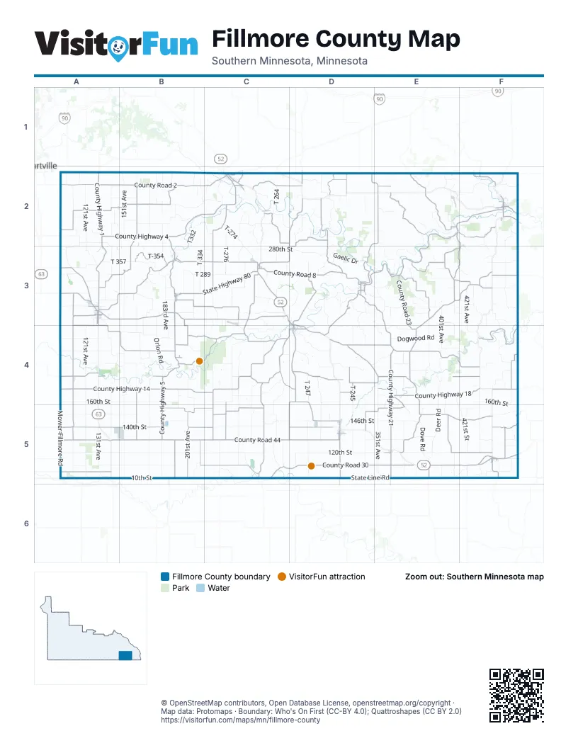
Street index of Fillmore County
Each street on the sheet and the grid squares it crosses.
- Historic Bluff Country Scenic BywayE2, F2, A3, B3, C3, D3, E3, D4
- County Highway 11D2, C3, D3, C4
- State Highway 44E5, F5
- State Highway 56A5
- State Highway 139D5
- North Broadway AvenueA3
- Main Street SouthC2
- Kansas Street NortheastD3, D4
- North Section AvenueA3
- South Section AvenueA3, A4
- North Mill StreetF2
- Auburn Avenue SouthD3
- Highway 52 SouthC2
- Highway 30 & 74C2
- Minnesota Road NorthwestC3, D3
- Main Avenue NorthD5
- Main Avenue SouthD5
- 3rd Street SoutheastC2, D5
- West Stevens AvenueF2
- Main Street NorthC2, E5
- South Mill StreetF2
- Kansas Street NorthwestD3
- West Grant StreetA3
- Sheridan Street EastD3
- West Jessie StreetF2
- Sheridan Street WestD3
- County Highway 5B2, C2, B3, B4, B5
- County Highway 1A2, A3, A4, A5
- County Road 44A5, B5, C5, D5
- State Highway 250D2, E2, D3
- County Highway 28E5, F5
- State Highway 80B3, C3
- 10th StreetA5, B5, C5
- South Main StreetF2, B3, E5, F5
- Parkway Avenue SouthD3
- Ashburn Street EastD3
- East Front StreetB3
- North Maple StreetF2, F5
- South Gold StreetB3
- South Maple StreetF2, F5
- North Gold StreetB3
- Parkway Avenue NorthD3
- West Alpine AvenueF5
- Oak AvenueB5
- County Highway 12A4, B4, C4, D4, E4, F4
- County Highway 21D2, D3, E3, E4, E5
- County Highway 14A4, B4, C4
- County Highway 8A3, B3, C3, D3
- 140th StreetA5, B5, C5, D5, F5
- County Highway 17D3, D4, D5
- County Highway 25E2, F2, E3, F3
- County Highway 15C4, C5
- County Highway 23E4, E5
- State Line RoadD5, E5, F5
- County Highway 10E3, F3, E4
- County Highway 38B2, A3, B3
- County Highway 30B5, C5, E5
- County Road 2A2, B2, C2, F2
- County Highway 18E4, F4
- County Road 30C5, D5, E5
- County Highway 20B5, C5
- Mower-Fillmore RoadA2, A3, A4, A5
- County Highway 16D4, E4
- County Road 101A2, B2
- County Highway 6C2, D2, D3
- 201st AvenueB3, B4, B5
- County Highway 7C2, C3
- County Highway 22C4, D4, D5
- County Road 115E4, D5, E5
- County Road 117B3, C3
- County Highway 13F4
- County Highway 24E5, F5
- County Road 108E3
- County Highway 4A2, B2
- County Road 8C3, D3, F5
- County Highway 104D2
- County Road 105E2
- 180th StreetA4, B4, E4, F4
- County Road 107E3, F3
- T-354B3
- County Road 23E3, E4
- County Highway 2A2
- 330th StreetA2, C2, E2
- County Road 40C2, D2
- County Highway 29F5
- County Highway 26A5
- County Highway 9C4, C5
- County Road 118C4
- County Highway 19D4, E4
- County Highway 27F2
- County Road 112F4
- County Road 114B4, B5
- Township Road 323C4, C5
- T 245D4
- County Highway 118B4, C4
- County Highway 3A4
- Diamond Creek RoadE3
- 212th StreetB4, C4
- 170th StreetA4, E4
- Bowery StreetB3
- County Highway 32D2, E2
- Rushford Village 40E2, F2
- Township Road 349B4
- County Road 106F2
- 178th StreetC2, A3, D4
- County Highway 39A3
- North Main StreetB3, A4, F5
- County Road 110C4
- 3rd Street SouthwestC2, D5
- County Road 11C3
- County Highway 37F3
- County Road 109A5
- Fillmore Street EastB3, D4
- County Highway 34F5
- County Highway 114B4
- Winona Street SoutheastC2
- Hillside Drive SoutheastC2
- East Main StreetA3, B3
- West Tracy RoadA3
- Greenleafton RoadC4, D4
- East Farmer StreetA3
- Main StreetB3, C3, E3
- Sample RoadA4
- West Prairie AvenueE5, F5
- East Park StreetF2, A3
- South Broadway AvenueA3
- 1st Avenue SouthwestD5
- Co 8B3
- North Line StreetB3
- County Road 113D2, E5
- West Park StreetF2, A3
- Saint Paul Street SouthwestD4
- Fillmore Co 106F2
- West County Highway 8C3
- Saint Paul Street NorthwestD3, D4
- South Street EastB3
- South Church StreetE2
- Coffee Street EastD3
- Juniper Road SoutheastC2
- Elm StreetB3, C3
- Mill StreetE2
- South River StreetF2
- Fillmore Street WestD4
- Ridge Road SouthD4
- East Prairie AvenueF5
- Center StreetA4
- Saint Anthony Street NorthD3, D4
- Spring Avenue NorthwestD3, D4
- County Road 43D2
- West Main StreetA3
- Elmwood Street WestD3
- North Robert StreetF5
- CR 8B3
- West Fillmore StreetB3
- South Huron AvenueA3
- County Road 25F2
- County Highway W20E5
- Larman DriveF2
- 120th StreetA5, B5, C5, D5, E5
- 121st AvenueA2, A3, A4, A5
- 160th StreetA4, B4, D4, F4, F5
- 151st AvenueB2, B3, B4, B5
- Deer RoadE4, E5
- 146th StreetB5, D5, E5
- Township Road 312B5, C5
- City of Rushford Village RoadE2, F2, E3, F3
- 150th StreetA5, B5, F5
- 351st AvenueE4, E5
- 341st AvenueD2, D3, D4, D5
- Township Road 298C4
- 110th StreetA5, B5
- 130th StreetA5, D5, E5, F5
- 331st AvenueD4, D5
- 230th StreetB3, C3, E3, F3
- Township Road 441A4, B4, A5
- Old River RoadE2, E3
- 141st AvenueA2, A3, A5
- 295th AvenueD3, D5
- 431st AvenueF4, F5
- T332B2, C2, B3
- Raven RoadA2, A3
- Orion RoadB3, B4
- 411th AvenueE3, E4, E5
- 171st AvenueB4, B5
- Township Road 301C4, C5
- 401st AvenueE3, E4, E5
- T 289B3, C3
- 183rd AvenueB3, B4
- County Road 102B2, C2
- 280th StreetA3, C3, D3
- 111th AvenueA2, A5
- T-334B3, C3
- Dogwood RoadE4
- 421st AvenueF3, F4, F5
- Township Road 321C5
- 371st AvenueE4, E5
- Ivy RoadD3
- 200th StreetA4
- Township Road 311C5
- T 403B2
- Ridgeview RoadE2, F2
- Harrow RoadD2
- 391st AvenueE3, E4
- Dove RoadE5
- Gaelic DriveD3
- Juniper RoadC2
- Knutson RoadE3
- 296th StreetA2, D2, E2
- T-274C2, C3
- 421st StreetF5
- 161st AvenueB2, B3, B4
- Goodview DriveD2, D3
- Fillmore DriveF3
- T-276C2, C3
- 250th StreetA3, E3, F3
- Maple DriveB4, B5
- 210th StreetA4, C4
- T-343B2, B3
- T 267C2, C3
- Grosbeak RoadD3, D4
- Evergreen RoadD4, E4
- Ox Trail RoadD3
- 190th StreetA4
- 181st AvenueB5
- Township Road 324C5
- 131st AvenueA5
- 320th StreetA2, B2, C2
- 305th StreetD4, D5
- City of Rushford Village Rd 8F2, F3
- 236th StreetA3, E3, F3
- 451st AvenueF3, F4
- 186th StreetE4, F4
- Township Road 315C4, C5
- Township Road 292C4
- Bear Paw RoadF3
- Arrowhead RoadF4
- 286th StreetA2, E2
- Township Road 440B4
- T 357A3, B3
- Everyday RoadE3
- Township Road 318C5
- Hickory RoadD3, D4
- 156th StreetD5, F5
- Township Road 432A4
- Jewel RoadC3
- 143rd AvenueA2
- Old Whalan RoadD3, E3
- Township Road 307C5, D5
- Township Road 316C5
- T 261C2, D2
- 165th AvenueB3, B4
- 270th StreetF3
- Holly RoadD3
- Township Road 313C5
- Quilt RoadA3
- T 247D4
- Township Road 367B4
- Oriole RoadB3
- T 359B3
- 220th StreetD4
- Iris DriveD2
- Township Road 305C4
- Township Road 317C4, C5
- Township Road 310C4
- Township Road 300C4
- T338B2
- T-344B3
- 455th AvenueF4, F5
- Township Road 255C5
- Rushford Village 15E2
- 240th StreetA3, F3
- Cedar Valley RoadE4, E5, F5
- Old Cave RoadB4
- T 250D4
- 218th StreetE4
- Dancer RoadE3
- T 335B3
- 245th AvenueC3
- T-286C3
- Township Road 232D4
- T-353B2
- T 271C2
- Karst RoadC2
- Edgewood RoadE4, E5
- Easy StreetE3
- Dew Drop RoadE3
- Finch RoadD4, E4
- T 264C2
- Township Road 226D4
- High RoadD3
- Drake RoadE4
- Gunflint RoadD2
- Country Line RoadF2
- T 339B3
- Township Road 383B4
- 134th StreetE5
- Maline RoadE3
- Soukup RoadE3
- Grand RoadD3
- T 327B2, C2
Things to do on the Fillmore County map
Places on the map
- Amherst Township
- Arendahl Township
- Beaver Township
- Bloomfield Township
- Bristol Township
- Canton
- Canton Township
- Carimona Township
- Carrollton Township
- Chatfield
- Chatfield Township
- Fillmore Township
- Forestville Township
- Forestville/Mystery Cave State Park
- Fountain
- Fountain Township
- Harmony
- Harmony Township
- Holt Township
- Jordan Township
- Lanesboro
- Mabel
- Newburg Township
- Norway Township
- Ostrander
- Peterson
- Pilot Mound Township
- Pin Oak Prairie SNA
- PIne Tree Apple Orchard
- Preble Township
- Preston
- Preston Township
- Rushford
- Rushford Sand Barrens SNA
- Rushford Village
- Spring Valley
- Spring Valley Township
- Sumner Township
- Whalan
- Wykoff
Next to Fillmore County
- Stewartville
© OpenStreetMap contributors, Open Database License, openstreetmap.org/copyright · Map data: Protomaps · Boundary: Who's On First (CC-BY 4.0); Quattroshapes (CC BY 2.0)















