

Minnesota map
Richfield map
About 36,491 people live here (Census Bureau, 2024 estimate). The sheet's index lists 135 streets; Pleasant Avenue South, West 75th Street and Crosstown Highway cross the most grid squares. Things to do inside the boundary: Wood Lake Nature Center.
Open the map (PDF, US Letter)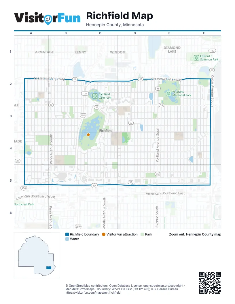
Street index of Richfield
Each street on the sheet and the grid squares it crosses.
- Crosstown HighwayA2, B2, C2, D2, E2
- Queen Avenue SouthA2, A3, A4
- Russell Avenue SouthA2, A3, A4
- Sheridan Avenue SouthA2, A3, A4, A5
- Thomas Avenue SouthA2, A3, A4, A5
- Upton Avenue SouthA2, A3, A4, A5
- Vincent Avenue SouthA2, A3, A4, A5
- Washburn Avenue SouthA2, A3, A4, A5
- West 62nd StreetA2, B2, C2, D2
- West 64th StreetA2, B2, C2, D2
- West 65th StreetA2, B2, C2, D2, C3
- Xerxes AvenueA2, A4, A5
- Girard Avenue SouthB2, B3, B4, B5
- Humboldt Avenue SouthB2, B3, B4, B5, C5
- Irving Avenue SouthB2, B3, B4
- James Avenue SouthB2, B3, B4
- Knox Avenue SouthB2, B3, B4, B5
- Logan Avenue SouthB2, B3, B4, B5
- Morgan Avenue SouthB2, B3, B4, B5
- Newton Avenue SouthB2, B3, B4, B5
- Oliver Avenue SouthB2, B3, B4, B5
- Penn Avenue SouthB2, B3, B4, B5
- West 63rd StreetB2, C2, D2
- Aldrich Avenue SouthC2, C4, C5
- Bryant Avenue SouthC2, C4, C5
- Colfax Avenue SouthC2, C4, C5
- Dupont Avenue SouthC2, C4, C5
- Emerson Avenue SouthC2, C3, C4, C5
- Garfield Avenue SouthC2, C3, C4, C5
- Grand Avenue SouthC2, C3, C4, C5
- Harriet Avenue SouthC2, C3, C4, C5
- Lyndale Avenue SouthC2, C3, C4, C5
- Mildred DriveC2
- Pleasant Avenue SouthC2, D2, C3, D3, C4, D4, C5, D5
- West 64th 1/2 StreetC2
- Woodlake LaneC2, C3
- 1st Avenue SouthD2, D3, D4, D5
- 2nd Avenue SouthD2, D3, D4, D5
- 3rd Avenue SouthD2, D3, D4, D5
- 4th Avenue SouthD2, D3, D4, D5
- Blaisdell Avenue SouthD2, D3, D4, D5
- Clinton AvenueD2
- East 62nd StreetD2, E2
- East 64th StreetD2, E2, F2
- East 65th StreetD2, E2, F2
- Nicollet Avenue SouthD2, D3, D5
- Pillsbury Avenue SouthD2, D3, D4, D5
- Stevens Avenue SouthD2, D3, D4, D5
- Wentworth Avenue SouthD2, D3, D4, D5
- 11th Avenue SouthE2, E3, E4, E5
- 12th Avenue SouthE2, E3, E4, E5
- 5th Avenue SouthE2, E3, E4, E5
- East 63rd StreetE2, F2
- Portland Avenue SouthE2, E3, E4, E5
- 13th Avenue SouthF2, F3, F4, F5
- 14th Avenue SouthF2, F3, F4, F5
- 15th Avenue SouthF2, F3, F4, F5
- 16th Avenue SouthF2, F3, F4, F5
- Bloomington Avenue SouthF2, F3, F4, F5
- Cedar Avenue SouthF2
- Richfield ParkwayF2, F3, F5
- West 65th 1/2 StreetA3
- West 66th StreetA3, B3, C3, D3
- West 67th StreetA3, B3, C3
- West 68th StreetA3, B3, C3, D3
- West 69th StreetA3, B3, C3, D3
- West 70th StreetA3, B3, C3, D3
- Xerxes Avenue SouthA3
- Forest DriveB3
- Lakeshore DriveB3, B4
- Lakeview AvenueB3
- Oakland TerraceB3
- Augsburg Avenue SouthC3, C4
- Bob's PlaceC3
- Emerson LaneC3
- Grand South AvenueC3
- Lake Shore Drive SouthC3
- Lynwood BoulevardC3
- Rae DriveC3
- Woodlake DriveC3
- Apple LaneD3
- Clinton Avenue SouthD3, D4, D5
- East 66th StreetD3, E3, F3
- East 67th StreetD3, E3, F3
- East 68th StreetD3, E3, F3
- East 69th StreetD3, E3, F3
- East 70th StreetD3, E3, F3
- 10th Avenue SouthE3, E4, E5
- Chicago Ave SouthE3, E4, E5
- Columbus Avenue SouthE3, E4, E5
- Elliot Ave SouthE3, E4, E5
- Oakland Avenue SouthE3, E4, E5
- Park Avenue SouthE3, E4, E5
- 17th Avenue SouthF3, F4, F5
- 18th Avenue SouthF3, F4, F5
- Old Cedar Avenue SouthF3, F4, F5
- West 70th 1/2 StreetA4, B4
- West 71st 1/2 StreetA4
- West 71st StreetA4, B4, C4
- West 72nd StreetA4, B4, C4, D4
- West 73rd StreetA4, B4, C4, D4
- West 74th StreetA4, B4, C4, D4
- West 75th StreetA4, C4, A5, B5, C5, D5
- Lake Shore Drive WestB4
- West 72nd 1/2 StreetB4
- Fremont Avenue SouthC4, C5
- Oak Grove BoulevardC4
- East 71st StreetD4, E4, F4
- East 72nd StreetD4, E4, F4
- East 73rd StreetD4, E4, F4
- East 74th StreetD4, E4, F4
- Pleasant Lane SouthD4
- West 73rd 1/2 StreetD4
- Diagonal BoulevardE4, F4
- Fern DriveF4
- Washburn CircleA5
- West 76th StreetA5, B5, C5, D5
- West 77th StreetA5, B5, C5, D5
- West 78th StreetA5, B5, C5, D5
- York Avenue SouthA5
- BBY Roof level 5B5
- Best Buy Visitor Parking Aisle 1B5
- Best Buy Visitor Parking Aisle 2B5
- Best Buy Visitor Parking Aisle 3B5
- Best Buy Visitor Parking Aisle 4B5
- Knox Avenue TransitwayB5
- 77th Street West Frontage RoadC5, D5
- Meridian CrossingsC5
- Tom Wood WayC5
- 77th Street East Frontage RoadD5, E5, F5
- East 75th StreetD5, E5, F5
- East 76th StreetD5, E5, F5
- East 77th StreetD5, E5, F5
- East 78th StreetD5, E5, F5
- Nicollet AvenueD5
Things to do on the Richfield map
Places on the map
- Academy of Holy Angels
- Activity Building
- Adams Hill Park
- Adams Hill Pond
- Aldi
- ALDI
- American Legion Hall
- Amphitheater at Lyndale Gardens
- Andale Taqueria & Mercado
- Arby's
- Arc's Value Village
- Audi Richfield
- Augsburg Park
- B'nai Emet Cemetery
- BBY Roof level 5
- Best Buy Headquarters
- Cedar Point Commons
- Christian Park
- Church of the Assumption
- Commons Pond
- Donaldson Park
- Hope Presbyterian Church
- Legion Lake
- Menards
- Milner Pond
- Minneapolis Jewish Cemetery
- Monroe Park
- Richfield High School
- Richfield Lake
- Richfield Lake Park
- Richfield Middle School
- Roosevelt Park
- Sheridan Park
- Shops at Lyndale
- Stark's Pond
- Target
- Veterans Memorial Park
- Washington Park
- Wood Lake
- Wood Lake Nature Center
Next to Richfield
- Armatage
- Diamond Lake
- Edinborough
- Kenny
- Windom
© OpenStreetMap contributors, Open Database License, openstreetmap.org/copyright · Map data: Protomaps · Boundary: Who's On First (CC-BY 4.0); U.S. Census Bureau















