

Minnesota map
Rochester Township map
About 123,624 people live here (Census Bureau, 2024 estimate). The sheet's index lists 130 streets; 60th Avenue Southwest, Bamber Valley Road Southwest and 40th Street Southwest cross the most grid squares. Things to do inside the boundary: Historic Mayowood.
Open the map (PDF, US Letter)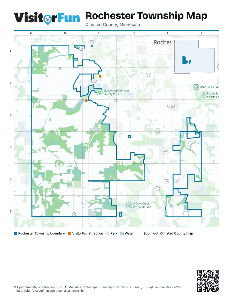
Street index of Rochester Township
Each street on the sheet and the grid squares it crosses.
- 60th Avenue SouthwestA1, A3, A4, A5, A6
- 8th Street SouthwestA1, B1, B2
- Country Club Road WestA1, B1, C1
- Partridge Drive SouthwestA1
- 44th Avenue Court SouthwestB1
- 45th Avenue SouthwestB1
- Ettenmoor Lane SouthwestB1, B2
- Irvin Lane SouthwestB1
- Courtney Court SouthwestC1
- Fox Hollow Court SouthwestC1
- Greenbriar Road SouthwestC1, C2
- Historic Drive SouthwestC1, C2
- Paxton Road SouthwestC1
- West Circle Drive SouthwestC1
- 18th Street SouthwestA2
- Boulder Creek Drive SouthwestA2
- Boulder Creek Lane SouthwestA2
- Boulder Point Lane SouthwestA2
- Cherry Woods Lane SouthwestA2, B2
- Creek Lane SouthwestA2
- Hamlet Road SouthwestA2, B2
- Jasmine Lane SouthwestA2
- Knob Creek Lane SouthwestA2
- Salem Road SouthwestA2, B2, A3
- Seasons Lane SouthwestA2
- Weatherhill Road SouthwestA2, B2
- Arrowhead Lane SouthwestB2, B3
- East Weatherhill Road SouthwestB2
- Mayowood Road SouthwestB2, C2, C3
- Meadow Ridge Drive SouthwestB2, C2
- Meadowlark Court SouthwestB2
- Oak Court SouthwestB2
- Oakland Court SouthwestB2
- Old Valley Road SouthwestB2, B3
- South Shore Lane SouthwestB2
- Trident Lane SouthwestB2
- Valley Court SouthwestB2
- Valley View Road SouthwestB2, C2
- Weatherhill Court SouthwestB2
- Weatherhill Lane SouthwestB2
- Weatherhill Ridge Court SouthwestB2
- Weatherhill Woods Lane SouthwestB2
- Westhill Drive SouthwestB2
- 34th Avenue SouthwestC2
- County View Court SouthwestC2
- Hill Court SouthwestC2
- Orchard Acres Lane SouthwestC2
- Cairnbrae Lane SouthwestA3
- Glencroft Lane SouthwestA3
- Heather Drive SouthwestA3
- Salem Road Court SouthwestA3
- Stenbrae Court SouthwestA3
- Franconia Lane SouthwestB3
- Galena Lane SouthwestB3
- Galesville Lane SouthwestB3
- Glenwood Lane SouthwestB3
- Glenwood Road SouthwestB3, C3, C4
- Ironton Lane SouthwestB3
- Mayo Prairie Lane SouthwestB3
- Mayo River Lane SouthwestB3
- Mayo Woodlands Road SouthwestB3, C3
- Meadow Crossing Lane SouthwestB3, B4
- Meadow Crossing Road SouthwestB3, C3
- Parkway Point Lane SouthwestB3
- Prairie Woods Lane SouthwestB3
- Wildflower Lane SouthwestB3, C3
- Woodland Valley Lane SouthwestB3, B4
- 28th Avenue SouthwestC3
- Alderock Lane SouthwestC3
- Bamber Hills Lane SouthwestC3, C4
- Bamber Valley Road SouthwestC3, C4, B5, C5
- Hardwood Court SouthwestC3
- Hawk Hill Lane SouthwestC3
- Headland Drive SouthwestC3
- Mayo Ridge Lane SouthwestC3
- Mayowood Hills Drive SouthwestC3
- St Peter Lane SouthwestC3
- Transit Court SouthwestC3
- Wild Rose Lane SouthwestC3
- Wright Road SouthwestC3
- 30th Street SoutheastF3, E4, F4
- 40th Street SouthwestA4, B4, C4, D4
- 55th Avenue SouthwestA4, A5
- Creekside Lane SouthwestA4, B4
- Creek View Lane SouthwestB4
- Heritage Drive SouthwestB4
- Heritage Lane SouthwestB4
- Millie Meadow Drive SouthwestB4, B5
- Millie Road SouthwestB4, A5, B5
- Milly Lane SouthwestB4
- Royal Oaks Circle SouthwestB4
- Royal Oaks Farm Drive SouthwestB4
- Royal Oaks Farm Lane SouthwestB4
- Royal Oaks Lane SouthwestB4
- Royal Oaks Place SouthwestB4
- Tara Lane SouthwestB4
- Mayowood Estates Circle SouthwestC4
- Mayowood Estates Drive SouthwestC4
- Trophy Woods Lane SouthwestC4
- 11th Avenue SouthwestD4, D5
- 18th Avenue SouthwestD4
- 32nd Street SouthwestD4
- Lillie Court SouthwestD4
- RacetrackD4, D5
- Windsor Chase Drive SouthwestD4
- Windsor Hills Lane SouthwestD4, D5
- Windsor Lane SouthwestD4, D5
- 11th Avenue SoutheastF4
- 20th Avenue SoutheastF4
- Simpson Road SoutheastF4
- 50th Street SouthwestA5, B5
- County Road 117A5
- 42nd Street SouthwestB5, C5
- Christopher Lane SouthwestB5
- County Road 8 SouthwestB5, B6
- Maggie May Lane SouthwestB5
- Pagenhart LaneB5
- Pagenhart Road SouthwestB5
- 31st Avenue SouthwestC5, C6
- 48th Street SouthwestC5
- Vista View Court SouthwestC5
- 48th Street SoutheastE5
- County Road 47E5, F5
- Gameday Drive SoutheastE5
- Maine Street SoutheastE5
- Saint Bridget Road SoutheastE5, E6
- 45th Street SoutheastF5
- 60th Street SouthwestB6, C6
- Conway Court SoutheastE6
- Quarve Road SoutheastE6
Things to do on the Rochester Township map
Places on the map
- Historic Mayowood Mansion
- Izaak Walton Wetlands
- Mayowood Corridor County Park
- Mayowood Lake
- Mayowood Quarry
- Racetrack
- Skyline Raceway
Next to Rochester Township
© OpenStreetMap contributors, Open Database License, openstreetmap.org/copyright · Map data: Protomaps · Boundary: U.S. Census Bureau, TIGER/Line Shapefiles 2024