

Minnesota map
Savage map
About 32,896 people live here (Census Bureau, 2024 estimate). The sheet's index lists 300 streets; Highway 13 South, Zinran Avenue and Ottawa Avenue cross the most grid squares. Also on it: Eagle Creek AMA, Hanrehan Lake and Prior Lake Aggregates.
Open the map (PDF, US Letter)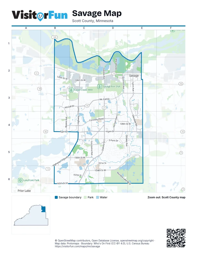
Street index of Savage
Each street on the sheet and the grid squares it crosses.
- Highway 13 SouthC2, C3, C4, B5, C5
- Egan DriveB4, C4, D4, E4
- 140th Street NortheastC4
- County Road 42 WestE4
- Dakota Street SouthD4, C5, D5, C6
- Mc Coll DriveC3, D3, E3
- Dakota Avenue SouthD3, D4, D6
- Dakota AvenueD2, D3, C6, D6
- West 137th StreetE3, B4, D4, E4
- Lynn AvenueE2, E3, E4
- Glendale RoadE3, E4
- McColl DriveB3, C3
- Texas AvenueC6
- South Park DriveC5, D5, E5
- Connelly ParkwayB4, C4, D4
- Frontage RoadC2, D2, B4, C4
- 154th Street WestC5, B6, C6, D6
- 126th Street WestB2, C2, D2, E2
- 160th Street SoutheastB6, C6
- Vernon Avenue SouthD3, D4
- Quentin AvenueD2, D3, D4, D5
- 150th Street WestB5, C5, D5, E5
- Natchez AvenueE2, E3, E4, E5
- Louisiana AvenueC3, C4, C5, C6
- Boone AvenueB2, B3, B4
- Hanrehan Lake BoulevardD5, E5, D6
- West Highway 101 Frontage RoadB2, C2
- Inglewood AvenueE2, E3, E4
- Quebec AvenueC3, C4, C5
- 123rd Street WestB2, C2, D2, E2
- Eagle Creek ParkwayB3, C3
- 138th Street WestB4, D4
- South Allen BoulevardD4, C6
- Zinran AvenueB2, C2, B4, C4, C5
- 141st Street WestC4, D4, E4
- West 133rd StreetD3, E3
- Preserve TrailB3
- 132nd StreetB3, C3
- Rhode Island AvenueC2, C4
- Allen BoulevardC4, C5
- Highway 13 Frontage RoadE2, C5
- West Hidden Valley DriveD4, E4
- Huntington AvenueE2, E3, E4
- 144th Street WestC5
- Utica AvenueD3, D4
- Highway 135B5
- Cates Lake DriveB5
- Nevada Avenue SouthC2
- Pennsylvania Avenue SouthC2
- 150th Street SoutheastB5
- West Burnsville ParkwayE5
- Greenway Avenue NortheastB4
- Ottawa AvenueE2, E3, D4, E4, D5
- Yosemite Avenue SouthD3, D4, D5
- Alabama Avenue SouthD3, D4, D5
- Glenhurst AvenueE2, E3, E4, E5
- Monterey Avenue SouthE2, E3, E4, E5
- Joppa Avenue SouthE2, E3, E4, E5
- Independence AvenueB2, B3
- West 135th StreetD3, E3, D4
- 140th Street WestD4, E4
- 157th StreetC6, D6
- West 144th StreetD4, E4, E5
- Virginia AvenueC3, C4, C5
- Edgewood AvenueD3, D4, D5, D6
- O'Connell AvenueD4, D5
- 136th Street WestB4, D4, E4
- West 132nd StreetD3, E3
- West 125th StreetD2, E2
- Kipling Avenue SouthE2, E3, E4, E5
- Maryland AvenueC3, C4, C5, C6
- Edgewater DriveD5, D6
- Kentucky AvenueC3, D3, C4, C5
- Murphy Lake BoulevardD6, E6
- Dufferin DriveD5
- 147th Street WestC5, D5, E5
- 151st StreetC5, D5
- 156th StreetC6, D6
- Carriage Hill RoadB3, C3, B4
- Vernon AvenueD1, D2
- 143rd Street WestD4, E4
- West 131st StreetD3, E3
- 125th Street WestB2, C2
- Sumter AvenueC5
- Princeton AvenueD2, E2, D4, D5
- River Wood DriveD5, E5
- Valley View DriveD5, D6
- Taylor DriveC3
- West 134th StreetD3, E3
- Wyoming AvenueC2, C6
- West 145th StreetD5, E5
- Brunswick Avenue SouthD3, D4, D5
- 139th Street WestC4, D4, E4
- Hampshire Avenue SouthC6, D6
- Quentin Avenue SouthD3, D4
- 148th Street WestC5, D5
- Aquila Avenue SouthB5, C5, C6
- River CrossingD5, E5
- River Oak DriveD5
- Bridgewater DriveD5
- 133rd StreetC3, D3
- Dan Patch DriveC3, C4
- West 124th StreetE2
- Flag AvenueB2, B5, B6
- Foxberry RoadC3, C4
- Woodhill DriveB4
- 146th Street WestC5, D5
- Nevada AvenueC3, C4
- Glendale TrailE4
- Amberwood LaneC4
- Hillsboro Avenue SouthB3, B4
- Overlook DriveD5
- Xenwood AvenueD2, D4
- 132nd LaneD3
- Hampshire AvenueC3, D3, D5
- Heatherton Ridge DriveB4
- Stafford TrailC5
- Creek WayB3
- Carriage Hill PlaceB4
- Zarthan Avenue SouthD3, D4
- 134th LaneD3, E3
- West 140th StreetC4, D4
- Yosemite AvenueD2, D6
- Dan Patch LaneC3, C4
- Hunters LaneC5
- Loftus LaneD4
- 127th TrailE3
- Credit View DriveD5
- Ensign AvenueB2
- 130th Street WestD3
- West 141st StreetD4, E4
- West 138th StreetC4
- Hillside TrailD5
- Jersey Avenue SouthC6
- 129th StreeetE3
- 137th Street WestB4
- Hanrehan TrailE5
- 124th Street WestB2, C2
- Foxberry DriveC3, C4
- Lake Ridge DriveC4, C5
- McAll BluffC3
- North River RunE5
- 128th Street WestC3
- Twin Ponds CurveC5
- 149th Street WestC5, E5
- West 131 1/2 StreetD3, E3
- 155th Street WestC6, D6
- Utah AvenueC4, C6
- Ashcroft RoadB4, C4
- Beverley LaneD5
- Ottawa DriveD3, E3
- South River RunE5
- Brook LaneD4, D5
- Alabama AvenueD4, D5
- Idaho AvenueC5
- Webster AvenueD3, D4
- Hillsboro WayB4
- Corporate Center DriveE4
- North Ridge DriveD5
- Allen DriveC4
- 141st StreetB4, E4
- Lone Oak DriveD5
- Chadwick DriveD4, D5
- 158th StreetC6
- 131st StreetE3
- Natchez LaneD4, E4
- Creek View AvenueC2, C3
- Creek Ridge LaneB3
- Credit River DriveD5
- Meadowood DriveD5
- Glenhurst Avenue SouthE3
- Woodridge WayB4
- Kestrel TrailC5
- 134th StreetB3
- Hillsboro AvenueB2
- River Bend PlaceE4
- Arbor LaneC5
- Oakcrest CircleE5
- 152nd Street WestB5
- Virginia Avenue SouthC4
- 159th StreetC6
- West Virginia AvenueC4
- 128th StreetE3
- Hampshire LaneD6
- Falcons WayB3
- Peninsula Point DriveC4
- Cedarview CircleC5
- Aquila AvenueB4, C4
- 147th TerraceC5
- Williamsberg DriveC3
- 139th StreetB4, C4
- Spruce LaneD5, E5
- 130th Lane WestD3
- Providence LaneD4
- Woodridge PathB4
- Joppa CircleE5
- Glenhurst LaneE4
- Maggie LaneB3
- West 136th StreetC4
- West 139th StreetD4
- 153rd PlaceC6
- Linden Cove LaneE5
- West 126th StreetD2
- Pennsylvania AvenueC3
- Utah PlaceC5
- Princeton CourtD4
- 151st Street WestB5
- Ridge Point CourtB4
- Woodbridge LaneD4, D5
- Huntington CircleE3
- Kings CourtB4
- Glendale LaneE3
- Country DriveB6
- Hamilton RoadC5
- 133rd CourtC3
- Oregon AvenueC5
- Kelleher CourtE5
- Meadowood CourtD5
- Woodbridge DriveD5
- West 129th StreetE3
- 137th LaneD4
- Featherstone DriveC4
- Oakborough DriveD5
- 132nd CircleC3
- 126th Terrace WestE2
- Aspen DriveD5, E5
- Oakcrest CourtE5
- Toledo CourtD4
- Clearwater CircleD5, E5
- Dufferin CourtD5
- Bohn CourtE3
- Windsor AvenueB3
- Loftus DriveD4
- Idaho CourtC5
- Palmer AvenueD2
- Ridgewood LaneB4, C4
- Trost TrailD4
- Oak View CourtD5
- Riverwood LaneD3
- 147th CourtC5, E5
- West 142 1/2 StreetD4, E4
- Huntington Avenue SouthE4
- Thorn Hill LaneC3
- Meadow LaneB3
- Inglewood Avenue SouthE2, E3
- Shoreside CourtC4
- Stafford CourtC5
- Dan Patch courtC3
- Colorado Avenue SouthD4
- Eagle Creek LaneB3
- West 136 1/2 StreetE4
- Overlook CourtD5
- Savanna Oaks DriveC4
- North View LaneD5
- Ponds Edge PathC5
- Webster CourtD4
- Idaho PlaceC6
- Summit Oaks BayB5, C5
- Preserve CourtB3
- Crimson LaneC5
- Elaine CourtD3
- Shoreline CourtC4
- River Oak PlaceD5
- Maryland CircleC3
- Oakwood PlaceD5
- 126th PlaceE2
- 136 StreetB3, B4
- Forest Glen CourtD3
- Horizon DriveB4
- 123 1/2 Street WestB2
- Vernon CircleD4
- Hillcrest DriveB3, B4
- Lockslie TrailC5
- West 133 StreetE3
- Cavell AvenueB2
- Country LaneB6
- Eagle Creek CircleB3, C3
- 123rd StreetB2
- Carriage Hill AlcoveC3
- Hillsboro CourtB4
- McCann CourtC5
- 157th TerraceC6
- Southridge LaneC5
- Featherstone TrailC4
- Meadow PlaceB3
- Parkridge LaneC5
- Parkridge WayC5
- Princeton CircleD4
- Carriage Hill DriveB4
- 152 PlaceC6
- Mustang LaneC5
- 153 Street WestD6
- 146th TerraceC5
- Aquila CircleB4
- Pinto LaneC5
- West 127th StreetE3
- Salem AvenueD4
- Southridge CourtC5
- 124th StreetD2, E2
- 145th Street WestC5
Places on the map
- Allina Health Savage Clinic
- Bethesda Church
- Boudin's Acres Park
- Buffalo Tap
- Canterbury Park
- Carriage Hill Place
- Cherrywood Dental
- Chipotle
- Christian Brothers Automotive Savage
- Community Park
- Costa Oil
- Crooked Pint Ale House
- Cub Foods
- Culver's
- Dakota Avenue
- Eagle Creek AMA
- Eagle Creek Park
- Eagle Ridge Middle School
- Featherstone Lake
- Featherstone Lake Walking Park
- Glendale Park
- Hanrehan Lake
- Hidden Valley Park
- Hy-Vee
- McCann Park
- McColl Pond
- Minnesota Valley State Recreation Area
- O'Connell Park
- Prior Lake Aggregates
- Prior Lake High
- Rice Lake
- Savage Fen SNA
- Schroeder's Acres
- Summit Pointe Park
- Target
- Twin Ponds
- Warren Butler Park
- Woodhill Park
Next to Savage
© OpenStreetMap contributors, Open Database License, openstreetmap.org/copyright · Map data: Protomaps · Boundary: Who's On First (CC-BY 4.0); U.S. Census Bureau















