

Minnesota map
Shakopee map
About 48,401 people live here (Census Bureau, 2024 estimate). The sheet's index lists 300 streets; Eagle Creek Boulevard, Marschall Road and 17th Avenue East cross the most grid squares. Things to do inside the boundary: Valleyfair.
Open the map (PDF, US Letter)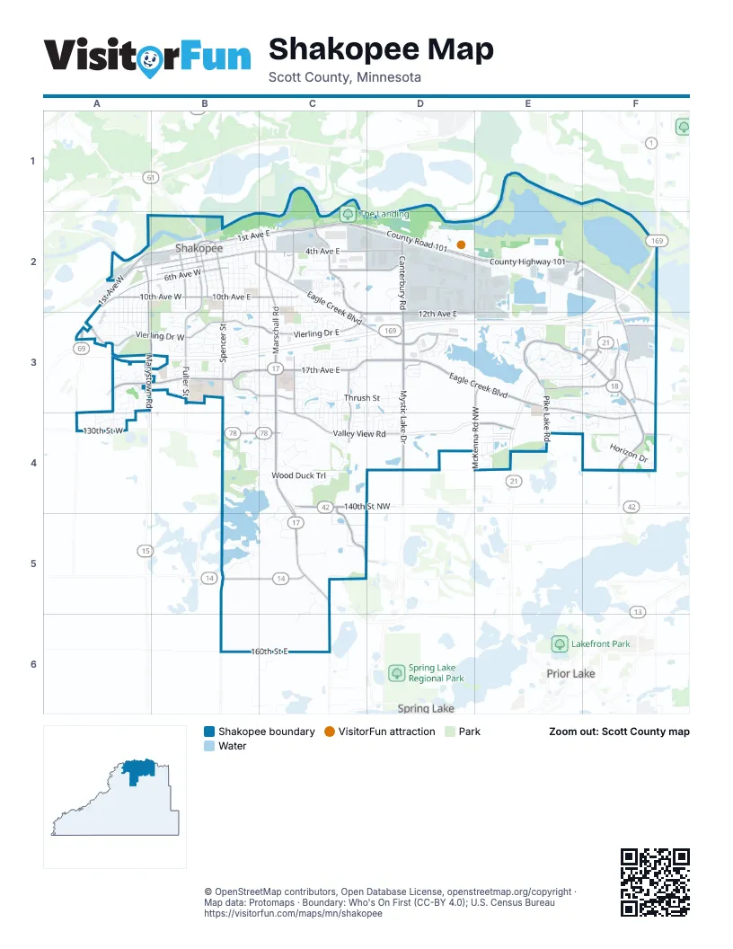
Street index of Shakopee
Each street on the sheet and the grid squares it crosses.
- Herrgott Memorial DriveE3, F3, E4
- Hansen AvenueF3
- Marschall RoadC2, C3, C4, C5, C6
- County Road 101C2, D2, E2
- County Highway 101C2, D2, E2
- 1st Avenue WestA2, B2, A3
- 140th Street NorthwestC4
- 1st Avenue EastB2, C2
- Holmes Street SouthB2
- Eagle Creek AvenueE4
- County Road 18F3, F4
- Marystown RoadA3
- 10th Avenue WestA2, B2
- 10th Avenue EastB2, C2
- West 150th StreetB5, C5
- County Road 78B4, C4
- 130th Street WestA4
- East County Road 78B4
- State Highway 300A2
- McColl DriveF4
- 17th Avenue EastA3, B3, C3, D3
- Eagle Creek BoulevardC2, C3, D3, E3, E4, F4
- Mystic Lake DriveD3, D4
- Southbridge ParkwayE3, F3
- Vierling Drive EastB3, C3
- Stagecoach RoadE2, F2, F3
- 4th Avenue EastB2, C2, D2
- Valley View RoadB3, C3, C4, D4
- Canterbury RoadD2, D3
- Shenandoah DriveC2, C3
- Crossings BoulevardE3, F3
- Vierling Drive WestA3, B3
- 12th Avenue EastC3, D3
- Unbridled AvenueC2, D2
- Spencer StreetB2, B3
- Dakota ParkwayC4, C5
- Sarazin StreetC2, C3, C4
- McKenna Road NorthwestE3, E4
- 6th Avenue WestA2, B2
- 3rd Avenue WestA2, B2
- Fuller Street SouthB2, B3
- TintaocankuE4
- Dean Lakes BoulevardD3
- Old Carriage Court NorthE3, F3
- Independence DriveC3, C4
- Adams Street SouthA2, A3
- Apgar Street SouthB2
- Pike Lake RoadE3, E4
- 4th Avenue WestA2, B2
- Townline AvenueB3, B4
- 5th Avenue WestB2
- Fuller StreetB3
- Koeper AvenueB3
- West Highway 101 Frontage RoadF3
- Preserve TrailF3
- Coneflower LaneD3
- 6th Avenue EastB2
- Gorman StreetB2, C2
- Old Carriage RoadF3
- Kinlock WayD3
- Old Brick Yard RoadA4
- Innovation BoulevardD2, E2
- 2nd Avenue EastB2
- Lewis Street SouthB2, B3
- Shakopee Avenue EastB2, C2
- Wood Duck TrailB4, C4
- 11th Avenue EastB2, C2, D2, E2
- Minnesota Street SouthB2, B3
- 160th Street EastB6, C6
- Horizon DriveF4
- Thrush StreetC3, D3
- Dakota Street SouthB2, B3
- Valley Industrial Boulevard SouthD2
- Tyrone Drive SouthC3, D3
- Market Street SouthB2
- Atwood Street SouthB2
- Harrison Street SouthA2, A3
- 3rd Avenue EastB2, C2
- Downing AvenueC3
- Tinta LaneE4
- Scott Street SouthB2
- Windsor Drive SouthE3
- Ponds WayC3, C4
- Bulrush BoulevardD3
- Oak Ridge TrailE3
- Pierce Street SouthB2, B3
- Molina StreetC4, D4
- Windermere WayA3
- Valley Park Drive SouthD2, D3
- Boiling Springs Lane EastF3
- Sommerville Street SouthB2
- Cardinal DriveC3, C4
- Jefferson Street SouthA2, A3
- Marcia LaneC4, C5
- Mathias RoadC3, C4
- 11th Avenue WestA2, B2, B3
- 7th Avenue EastB2
- 70th StreetE2
- Fairhaven DriveB4
- Monroe Street SouthA2, A3
- Shumway Street SouthB2
- Park PlaceD2, D3
- Foothill TrailE3, F3, E4
- Jennifer LaneB4, C4
- Philipp DriveC3
- Ormond DriveC3, C4
- Muhlenhardt RoadF4
- 12th Avenue WestA3
- Madison Street SouthA2, A3
- Oxford Road SouthE3
- Vista Ridge LaneB5
- 8th Avenue EastB2
- Evergreen LaneC3, C4
- Philipp WayC3, D3
- Spring Lake DriveE3, F3, F4
- Omega DriveC3, C4
- Naumkeag Street SouthB2, B3
- Whispering Oaks TrailF4
- Jackson StreetA2, A3
- Barrington DriveB4
- 7th Avenue WestB2
- Checkered Flag BoulevardE2
- Hartley Boulevard SouthE3
- Valleyfair DriveD2
- Redwing DriveE4
- Bluff Avenue EastB2, C2
- Whitehall RoadE3
- Tyler Street SouthA2, A3
- Leavitt Woods LaneC4
- Cambridge RoadE3
- Saint Francis AvenueC3
- Williams StreetC3, C4
- Hackberry LaneD3, D4
- Aloha AvenueA3, A4
- Danube AvenueB3
- Crane StreetC4, D4
- Zumbro AvenueA3, A4
- Oxford Road NorthE3
- Pheasant Run StreetC3, C4
- Astoria DriveA3, A4
- Hauer TrailC2, C3
- Countryside DriveB3
- Patterson DriveB3, C3, B4
- Dominion AvenueC4
- Heritage DriveC3
- Main Street SouthB2
- 22nd Avenue EastE4
- Westchester AvenueB3
- Polk Street SouthA2, A3
- Lusitano StreetB3
- Blakewood DriveD3
- Sage LaneB3
- Ramsey StreetC2, C3
- Pennisula Point RoadB5
- Arcadia StreetA4
- Thistle LaneB3
- Bluestem AvenueB3
- Portage LaneF3, F4
- 2nd Avenue WestB2
- Primrose LaneB3
- Ardennes AvenueB3
- Arabian AvenueB3
- 5th Avenue EastB2
- Quail DriveC3
- Greenway AvenueC2
- Boulder PointeA3
- Eastway AvenueC2
- Alysheba RoadC2
- Appleblossom LaneB3
- Parkway AvenueC2
- 3rd Avenue NorthwestA2
- Caspian LaneB3
- Maras StreetF3
- Van Buren Street SouthA2, A3
- Norton DriveC5
- Prairie Street SouthB2
- Wyndam DriveC3
- Winterberry LaneD3, D4
- EncoreD2
- Whitetail DriveD4
- Deans Lake RoadD3
- Harvest LaneB3
- Onyx DriveC3
- Stone Meadow BoulevardA3
- Tamarack RoadA3
- 12th AvenueE2, D3, E3
- 13th Avenue WestA3
- Savana DriveD3
- Roundhouse StreetC2
- Anton WayC3
- Riverside DriveF3
- Chateau AvenueC4
- East Mound StreetB3
- Eaglewood LaneC5
- Staghorn DriveC3, C4
- Spring Lake LaneF3
- Aztec AvenueA3
- Providence DriveB3
- Showtime DriveD2, D3
- Innovation DriveE2
- Falmouth CurveE3
- Prairie LaneC2, C3
- Valley Park DriveD2, E2
- Waterlily WayE3
- Granite DriveC3
- Main StreetB2
- Tasha BoulevardC3
- Princeton AvenueB3
- Valley Creek LaneB4, C4
- Basenji CurveB3
- Wildwood DriveF4
- Penstemon LaneF3
- Westchester LaneB3
- Rock Elm RoadC4
- Groveland WayC3
- Highpoint CurveB3, C3
- Stonebrooke DriveB4
- Windsor Drive NorthE3
- Trinity DriveC3, D3
- Carlisle CurveE3
- Limestone DriveC3
- Thomas AvenueB2, B3
- Waters Edge AvenueE4
- Waverly AvenueE4
- Aragon DriveA4
- Windsor LaneE3
- Balinese StreetC3
- England WayC3
- Shakopee Avenue WestB2
- Hartley Boulevard NorthE3
- Ridge Creek TrailE3
- 21st Avenue SouthE4, F4
- Maple TrailC4
- Sussex LaneE3
- Homestead StreetB3
- Bridge Crossing EastC5, C6
- Brookview StreetE4
- Orchard ParkwayB3
- Promise AvenueC4
- McIntosh CircleB3
- Green Ash AvenueC4
- Roundhouse Circle SouthC2
- Grove DriveF3
- Pine Tree LaneC3, D3
- Willow CourtA3
- Latour DriveA4
- Whitney AvenueB3
- Westridge DriveB5
- Columbine LaneB3
- Jutland AvenueB3
- Mockingbird AvenueC3
- Halli RoadC3, C4
- Hennes AvenueB2, B3
- Sibley Street SouthC2
- Chester StreetC3, C4
- Levee DriveB2
- Brittany DriveC3
- 18th Avenue EastC3
- Monnens AvenueB3
- Wacipi DriveC5
- Canterbury Access RoadC2
- Wolf Ridge AvenueC4
- Liberty CircleB3
- Presidential LaneA3
- King AvenueC3
- Meadowlark LaneD4
- Queen AvenueC3
- Antique AutosD2
- Emerald Lane EastC3
- Liberty StreetB3
- August DriveA3
- Blue Jay StreetC3, C4
- Brittany CourtC3
- Alden AvenueC3
- Grove CircleF3
- Dongola LaneB3
- Monarch StreetB3
- Appaloosa AvenueB3
- Pembina LaneD4
- Coral Bell DriveD3
- Swift StreetC2
- Tinta CircleE4
- Lund WayA3
- Lakeview Drive SouthB4
- Attenborough StreetA3
- Wyndam CourtC3
- Cobblestone WayB3
- Pinewood DriveC2
- Karner DriveD3
- Pottok LaneB3
- French Trace AvenueC3
- Eaglewood DriveC5, C6
- Cavanaugh DriveC2
- Peace AvenueC4
- Wakefield CircleE3
- Fillmore Street SouthB2
- Wren AvenueD3
- Hickory LaneB3
- Cambridge WayB4
- Legion Street SouthC2
Things to do on the Shakopee map
Places on the map
- 17th Avenue Sports Complex
- Bdedan
- Blue Lake
- Bluff View
- Deans Lake
- East Village
- FedEx Ground
- Fisher Lake
- Hackney Park
- Horizon Heights Park
- Huber Park
- Lions Park
- Lowe's
- Meadows Park
- Memorial Park
- Minnesota Correctional Facility-Shakopee
- Minnesota Valley National Wildlife Refuge
- Minnesota Valley State Recreation Area
- Mystic Lake Amphitheater
- Neil Johnson Softball Complex
- O'Dowd Lake
- Planet Snoopy
- Prairie Bend Park
- Quarry Lake
- Raguet Wildlife Management Area
- Ridge Creek Park
- Riverside Fields Park
- Riverview Park
- Royalty Park
- Saint Francis Regional Medical Center
- Scenic Heights Park
- Shakopee Archery Range
- Shakopee High School Grounds
- Shakopee Sand & Gravel, Inc.
- Southbridge Community Dog Park
- Stonebrooke Golf Course
- Tahpah Park
- The Landing
- Valleyfair
Next to Shakopee
- Prior Lake map
- Spring Lake
© OpenStreetMap contributors, Open Database License, openstreetmap.org/copyright · Map data: Protomaps · Boundary: Who's On First (CC-BY 4.0); U.S. Census Bureau















