

Minnesota map
St. Cloud map
About 57,229 people live here (Census Bureau, 2024 estimate). The sheet's index lists 300 streets; 8th Avenue South, Roosevelt Road and 2nd Street South cross the most grid squares. Things to do inside the boundary: Crossroads Center.
Open the map (PDF, US Letter)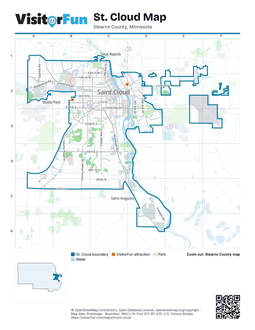
Street index of St. Cloud
Each street on the sheet and the grid squares it crosses.
- MN Highway 15B2
- Roosevelt RoadC2, C3, C4, C5
- Division StreetB2, C2
- 2nd Street SouthB2, C2, B3, C3
- 1st StreetC2
- County Road 75A2, D5, D6
- 3rd Street SoutheastC2, D2, E2
- Granite City CrossingC2
- 2nd StreetB2
- US-10 ED2
- 3rd StreetD2
- Veterans DriveA2, B2, C2
- Cooper Avenue SouthC2, C3, C4
- 9th Avenue NorthC1, C2
- West Saint Germain StreetC2, B3, C3
- 3rd Street NorthB2, C2
- University Drive SouthC2
- 2nd Street NorthB2, C2
- 15th Avenue SoutheastD2, D3
- 1st Street NorthB2, C2
- 12th Street NorthB2, C2
- 44th Avenue NorthB2
- 10th Avenue SouthC2, C3
- Opportunity DriveD6
- Minnesota Boulevard SoutheastD3
- 10th Avenue NorthC1, C2
- East Saint Germain StreetC2, D2
- 33rd Avenue SouthB2, B3
- 9th Avenue SouthC2, C3
- Cooper Avenue NorthB2, C2
- County Road 4A1, A2
- 3rd Street NortheastB2, C2
- County Road 8 SoutheastD3
- Veterans BridgeC2
- 33rd Street SouthB4, C4
- County Road 74B3, B4, A5
- County Road 136B3, B4, B5
- Clearwater RoadC3, C4, D4, D5
- Ridgewood RoadA2, B2
- Westwood ParkwayA2
- 2nd Street SoutheastC2, D2, E2, F2
- 250th StreetA5, B5
- Kilian Boulevard SoutheastD2, D3
- 33rd Avenue NorthB1, B2
- 6th Avenue NorthC1, C2, D2
- County Road 134B1, B2
- Lincoln Avenue SoutheastD2
- Cypress RoadA1, A2
- Northway DriveC1, C2
- 25th Avenue NorthC1, C2
- 22nd Street SouthB3, C3
- 45th Avenue SoutheastE2, E3
- 15th Street NorthB1, C1
- 4th Avenue SouthC2, C3, D5
- 5th Street NorthB2, C2
- 9th Avenue SoutheastD2, D3
- 7th Avenue SouthC2, C3
- 12th Avenue NorthC1, C2
- 7th Avenue NorthC2
- 7th Street SoutheastD2
- 11th Street NorthB2, C2
- University Drive SoutheastC2, D2, D3
- 1st Street SouthB2, C2
- 7th Street SouthC2, B3
- Saukview DriveA2
- 47th Avenue NortheastE1, E2
- 5th Avenue SouthC2, C3
- 17th Street SouthC3
- 12th Street SoutheastD2, E2
- 8th Avenue SoutheastD2, D3
- 45th Avenue NortheastE1, E2
- 36th Street SouthB4, C4
- Washington Memorial DriveC2, C3
- 16th Street SouthB3, C3
- 54th Avenue NorthB2
- Pine Cone Road SouthB1
- 14th Avenue SouthC2, C3
- 13th Street NorthC2
- 20th Avenue SoutheastD3
- 25th Avenue SouthC2, C3
- 5th Avenue NorthC2
- Old Highway 52A2
- Lincoln Avenue NortheastC1, C2, D2
- Frontage RoadD2, C3, C4
- 14th Avenue SoutheastD2, D3
- Wilson Avenue NortheastC2
- Franklin Avenue NortheastC1, D1, D2
- Wilson Avenue SoutheastC2, D2
- Highway 10 NorthD1, D2
- Maine Prairie RoadB3, C3
- County Road 6A4, B4
- 12th Avenue SouthC2, C3
- Centennial DriveC2
- 27th Street SoutheastD3
- Veteran's DriveC2
- 35th Avenue NortheastE2
- 40th Avenue SoutheastE2
- 16th Avenue NorthC2
- County Road 137B3
- County Road 120A1, B1
- Oak Grove Road SouthwestB3
- Waite Avenue SouthB2, B3
- 4th Street SoutheastC2, D2
- Traverse RoadC3
- 1st Street SoutheastC2, D2
- 7th Street NortheastC2, E2
- Highway 10 SouthD2
- 55th Avenue SoutheastF2, F3
- East Division StreetD2
- Quarry RoadB3
- 19 1/2 Avenue SouthC2, C3
- 17th Street SoutheastD3, F3
- 29th Avenue SouthB2, B3
- 14th Avenue NortheastD2
- 8th Street NorthC2
- 27th Avenue SouthB2, C2
- 63rd AvenueA5
- 8th Street North / Veterans DriveC2
- West Lake BoulevardC2
- Walnut CircleD3
- 35th Avenue SoutheastE2
- Lincoln Avenue SouthC1
- 55th Avenue NortheastF2
- County Road 63D2
- 40th Street SouthA4, B4, C4
- 255th StreetB5, C5
- 7th Street NorthB2, C2
- 21st Avenue SouthC2, C3, B4, C4
- 8th Avenue SouthC2, C3, C4, D5, D6
- 24th Avenue NorthC1, C2
- 29th Avenue NorthB1, B2
- 32nd Avenue NorthB1, B2
- 4th Street NorthB2, C2
- Franklin RoadD5, D6
- 15th Avenue SouthC2, C3, C4
- 9th Street NorthB2, C2
- 10th Street NorthB2, C2
- 8th Street SouthC2
- 23rd Avenue NorthC2
- 11th Avenue NorthC1, C2
- 31st Avenue NorthB1, B2
- 27th Avenue NorthB2
- 14th Street SouthB3, C3
- 22nd Avenue NorthC2
- 38th Street SouthB4, C4
- 30th Avenue NorthB2
- Riverside Drive SoutheastC2, D2
- 14th Street NorthB2, C2
- Glenview LaneA1, B1
- Centracare CircleB1
- 6th Avenue SouthC2, C3
- 21st Avenue NorthC2
- 11th Street SouthC3
- 35th Avenue NorthB2
- 26th Avenue NorthC2
- 13th Street SouthB3, C3
- 28th Avenue NorthB2
- Walden WayC3, C4
- 11th Avenue SouthC2, C3
- 34th Avenue NorthB1, B2
- West Oakes DriveB1, B2
- 36th Avenue NorthB1, B2
- 37th Avenue NorthB2
- 6th Street NorthC2, D2
- 13th Avenue SoutheastD2, D3
- Plum Creek DriveC4
- 16th Avenue SouthC2, C3, C4
- Forest DriveC1
- 20th Avenue NorthC2
- Rolling Ridge RoadA2
- 13th Avenue NorthC2
- Hadrian RoadC4
- Park DriveB1, C1
- Southway DriveC4
- 10th Avenue SoutheastD2, D3
- Kenwood RoadA1
- 13th Avenue SouthC2, C3
- Heatherwood RoadD5
- Montrose RoadC4, D4
- Tee-To-Green StreetF2
- 2nd Avenue NortheastB2, C2
- Glenn Carlson DriveD5, D6
- Riverside Drive NortheastC2
- Northwood LaneA1
- 12th Avenue SoutheastD2, D3
- 19th Avenue NorthC2
- 4th Street SouthC2, B3
- 8th Avenue NorthC2
- 9th Street SouthC2
- 6th Street SouthC2, B3
- 3rd Avenue SouthC2, C3
- 18th Street NorthA1, C1
- 15th Street SouthB3, C3
- 18th Street SouthB3, C3
- West Whitney ParkC1
- 60th Street SouthD5
- County Road 122B4
- Park Avenue SouthB2, B3
- Woodhill RoadC3
- 8th AvenueC1, C2
- Hidden Acres CircleB4
- Goettens WayC3
- 16th Street NorthA1, B1
- 17th Avenue NorthC2
- 25th Street SouthB3, C3
- 5th Avenue SoutheastC2, D2
- Liberty Glen LoopD3
- 37th Street SouthB4, C4
- 24th Avenue SouthC2, C3
- 73rd Avenue NorthA1, A2
- Prairie Hill RoadC3
- 30th Street SouthB3, C3, B4
- Cory LaneA2
- 11th Avenue SoutheastD2, D3
- 1st Avenue SouthC2, D2, C3
- 58th AvenueB4, B5
- Bent Tree DriveB4, C4
- Somerset BoulevardB1, A2, B2
- 13th Street SoutheastD2
- 19th Street NorthA1, B1, C1
- Timberdoodle DriveB1
- 25th Street SoutheastD3
- 43rd Avenue SouthB3, B4
- Topaz Parkway SouthB4, C4
- 15th Avenue NorthC2
- Stone Gate DriveB4
- Pattison RoadA1, A2
- 10th Street SoutheastD2
- 41st Avenue SouthB2, B3
- 5th Street NortheastC2, E2
- 39th Street SouthC4
- Imperial DriveC3
- 19 1/2 Avenue NorthC2
- Marquette DriveC3
- 16th Avenue SoutheastD2, D3
- 16th Street SoutheastD3
- Crescent Ridge TrailC3, C4
- 11th Street SoutheastD2
- Nottingham RoadB4
- Stockinger DriveC1
- 42nd Avenue SouthB3, B4
- Case LaneB1, B2
- Chelmsford LaneC4
- Stearns WayB1, C1
- Oak RoadB1
- Wildflower RoadC4
- 17th Avenue SouthC2, C3
- Southwood TrailC4
- Anderson AvenueB2
- Serenity DriveC3
- Laurel RoadA1
- Westwind RoadA1, A2
- Highland TrailC4
- Hurst Castle RoadA1, B1
- Santa Fe TrailC4
- 38th Avenue NorthB2
- 18th Avenue SouthC2, C4
- Bromo AvenueA1
- Mulberry RoadA1, A2
- Quail Road NortheastE1
- Spruce StreetB2
- Savanna AvenueA2
- 4th Avenue NortheastC2
- 3rd Avenue NortheastC2
- 60th Avenue SoutheastF2
- 9th Street SoutheastD2
- 18th Avenue NorthC2
- Wildwood RoadA1, A2
- Pebble Creek DriveA2
- McLeland RoadB2
- 6th Street NortheastC2, E2
- Apollo Avenue NortheastC1, C2, D2
- Meadow Rose BoulevardC3
- Center StreetB1
- Mill Creek CircleC1
- 5th Street SouthC2
- Woodland RoadD2
- 23rd Street SouthB3, C3
- 2nd Street NortheastC2, D2, E2
- 40th Avenue SouthB3, B4
- Cherry LaneD2
- Glenview LoopA1
- Sportsmans Island RoadC3
- 5th Avenue NortheastC2
- 4th Street NortheastB2, C2
- Maple LaneD2
- Halliday RoadC3
- Atwood DriveC3
- Maywood DriveA2
- Poppy RoadA1, A2
- Tranquility DriveC3
- Casselberry RoadA1
- 34th Avenue SouthB4
- 14th Avenue NorthC2
- 9th Street NortheastC1, E2
- McKinley Place SouthC2, C3
- Breckenridge AvenueC2
- 28th Street SouthC3
- Black Heath DriveC4, D4
- Deercreek TrailC4
Things to do on the St. Cloud map
Places on the map
- Angushire Golf Club
- Apollo High School
- Army Aviation Support Facility
- Assumption Cemetary
- Calvary Cemetery
- Centennial Park
- Centennial Plaza
- Centracare Health Plaza
- CentraCare Plaza Clinic
- Clark Field
- Country Hearth
- Crossroads Center
- Diamond Pink Quarry - St Cloud
- Division Place Shopping Center
- Eastman Park
- FedEx
- George Friedrich Park
- Gilleland Chevrolet
- Hennen’s Furniture
- Heritage Park
- Hester Park
- Knights of Columbus Park
- Lake George
- Life Assembly of God
- Little Woods
- Oak Hill Elementary School
- Quarry Creek Nursery
- Riverside Park
- Saint Cloud
- Saint Cloud Hospital
- St. Cloud Country Club
- St. Cloud State University
- St. Cloud VA Health Care System
- St. Scholastica Convent
- Stonegate Centre
- Technical High School
- The Big Woods
- Veterans Golf Course
- Warner Lake
- West Whitney Park
Next to St. Cloud
- Saint Augusta
- Sauk Rapids map
- Waite Park
© OpenStreetMap contributors, Open Database License, openstreetmap.org/copyright · Map data: Protomaps · Boundary: Who's On First (CC-BY 4.0); U.S. Census Bureau















