

Minnesota map
Stearns County map
About 163,997 people live here (Census Bureau, 2024 estimate). The sheet's index lists 300 streets; Main Street, 1st Street and I-94 W cross the most grid squares. Things to do inside the boundary: Crossroads Center and Hill Museum & Manuscript Library.
Open the map (PDF, US Letter)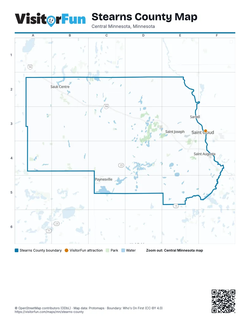
Maps inside Stearns County
2 maps inside, from the street map of Stearns County down.
Street index of Stearns County
Each street on the sheet and the grid squares it crosses.
- I-94 WA2, B2, C2, D3, E3, E4
- I-94 ED3, E3, E4
- MN Highway 15E3
- MN Highway 23E3, C4, D4, E4
- County Road 75E3, F4
- Roosevelt RoadE3, F3, F4
- 2nd Street SouthB2, E3, F3, D4, C5
- Division StreetE3, F3
- 1st StreetB2, C2, E2, D3, E3, F3, C4
- 3rd Street SouthE3, F3, D4
- 2nd StreetD2, D3, E3, A4, C4
- Yorkshire RoadB2
- Main Street SouthB2, E5
- 1st AvenueC2, B3, C3, D3, E3
- State StreetB3, C4
- 4th Street SoutheastB2, D4
- MN-15E4
- Main Street NorthB2, E5
- 4th Street SouthwestB2, D4
- 25th Street NortheastA4
- Washburne DriveC5
- Wells StreetA4
- Granite City CrossingF3
- 4th Street WestD4
- State Highway 4B3, B4, C4
- County Road 7E4, F4, E5
- State Highway 238C2, D2, D3
- State Highway 22D4, D5
- County Road 4E3
- 375th AvenueB2, B3
- 1st Street NorthB2, E3, F3, D4
- County Road 137E3, E4
- 9th Avenue NorthE3, F3, D4
- 3rd Street NorthB2, E3, F3, A4, D4
- Pine Cone Road SouthE3
- Business 23C5
- Veterans DriveE3, F3, C5
- County Highway 72A2, B2
- 2nd Street NorthB2, E3, F3, D4
- County Road 47C2, E4
- Cooper Avenue SouthF3, F4
- Main StreetB2, E2, B3, C3, A4, B4, C4, D4, C5
- 7th Street SouthB2, D3, E3, F3
- 10th Avenue NorthE3, F3, D4
- 10th Avenue SouthE3, F3, D4
- 450th StreetA2, C2, D2, E2
- West Saint Germain StreetE3, F3
- 12th Street NorthE3, F3, D4
- 8th Street SouthB2, D3, E3, F3
- 44th Avenue NorthE3
- University Drive SouthF3
- Viking TrailB2
- 2nd Avenue SouthB3, E3, F3, D4
- 3rd Street NortheastB2, C2, E2, D3, E3
- Railroad AvenueB2, D3, F3
- Opportunity DriveF4
- 12th Street SouthB2, E3, F3
- State Highway 28B2
- 9th Avenue SouthF3, D4
- 33rd Avenue SouthE3
- Beltline RoadB2
- Cooper Avenue NorthE3, F3
- Grant Avenue SouthwestD4
- State Street NorthD5
- 8th StreetD3
- 190th Street NortheastC4
- State Highway 4 NorthB3
- Veterans BridgeF3
- County Road 17B2, C2, D2, E2
- County Road 26A2, A3, A4
- County Road 44F4, E5, F5
- County Road 13A3, B3, A4
- County Road 32B4, C4
- County Road 19A4, B4, C4
- County Road 9D2, D3, B4, D4
- County Road 2E3, D4, E4, D5
- County Road 12C4, D4, D5
- County Road 18A2, A3
- County Highway 12C3, C4
- County Road 30B3, C3
- 115th AvenueE2, E3, E4
- County Road 14B3, C3, A4, B4, C4
- County Highway 34C5, D5
- County Road 8E4, E5
- 420th StreetA2, B2, C2, E2
- County Road 130C4, C5
- County Road 1E2, E3, F3
- River StreetD2, E2, E3, C4, C5
- County Highway 45F4, E5, F5
- County Road 141E4
- County Road 41C3, D3, C4
- County Road 3D2, E2, E3
- 185th StreetC5, D5, E5, F5
- County Road 157C2, C3, D3
- County Highway 13B2, B3
- County Road 10D2, D3
- 33rd Street SouthE4, F4
- County Highway 9D2, D5
- County Highway 16C4
- County Highway 175B3, B4
- County Highway 33C4, C5
- County Road 48E4, E5
- County Road 136E3, E4
- County Road 168B2, C2
- County Road 185B2
- County Road 186B2
- County Road 183A2
- County Road 138E3, E4
- County Road 177C3, C4
- County Road 23C4, D4
- County Road 176B3, C3
- County Highway 21D4, D5
- County Road 5E2
- County Highway 27A3
- 30th Avenue NorthE2, E3
- County Road 170B2
- County Road 160D4, E4
- County Road 51D3, E3
- County Road 145F4, F5
- County Road 54D3
- County Highway 49D4
- 270th StreetA4, D4, E4
- 395th StreetB2, D2, E2
- Ridgewood RoadE3
- County Highway 2D4, D5
- County Highway 22A3, B3
- County Highway 40C3, D3
- County Road 74E3, E4
- 290th StreetB3, C3, D3
- County Road 28A3, B3
- County Road 167C2
- County Road 29B2, B3
- Saint Anna DriveD2, D3
- County Highway 11C2
- Pine Cone Road NorthE2, E3
- County Road 52D2, E2
- County Road 152D2
- County Road 6E4
- 7th Street NorthD3, E3, F3
- County Highway 42C4, D4
- County Road 15B4
- County Road 192A3
- County Road 134E3, F3
- County Road 31B3, C3
- County Road 184A2, B2
- Colfax Road NorthwestA4
- County Road 139E4
- County Road 39C2
- 5th Street NorthB2, D3, E3, F3, D4
- County Highway 37C2
- 250th StreetC4, E4, F4
- County Road 129B4
- Riverside Avenue NorthE2, E3
- County Road 175B3
- 1st Street SouthB2, E3, F3, D4
- County Road 71D4
- Clearwater RoadF3, F4
- Central Avenue NorthE2, D4
- County Highway 50D4
- County Highway 36C2
- County Road 149E5
- 6th Avenue NorthE3, F3
- County Road 140D4, E4
- Westwood ParkwayE3
- County Line Rd 68B4, C4
- 5th Avenue NorthE3, F3, D4
- County Line RoadC4
- County Road 199A3, B3
- 7th Avenue SouthE3, F3, D4
- County Road 120E3
- Jade RoadE3, E4
- 455th AvenueA3
- Collegeville RoadE3
- 7th Avenue NorthE3, F3
- County Road 197A4, B4
- Heritage DriveE3, F4
- County Road 115E4, F4
- County Road 65B2
- Main Street EastC2, E2, C3, D4
- County Highway 143F4
- 4th Avenue SouthE3, F3, F4
- 27th Street NorthE3
- County Highway 23C3, C4
- 11th Street NorthE3, F3, D4
- Roseville Road NortheastC4, C5
- County Road 121E3
- 19th Avenue SouthE3, F3
- County Road 20C5
- 12th Avenue NorthE2, E3, F3, D4
- Graniteview RoadE3, E4
- 6th Avenue SouthE3, F3, D4
- 17th Street SouthE3, F3, E4
- 135th AvenueE2, E3, E4, E5
- East Main StreetB2, C2, D4, C5
- 15th Street NorthE3, F3
- County Highway 35C2
- Meeker-Stearns StreetD5, E5
- 6th Street SouthB2, E3, F3
- 33rd Avenue NorthE3
- Riverside Avenue SouthE3
- Colfax Road NortheastA4
- Saukview DriveB2, E3
- 22nd Street SouthE3, F3
- Cemetery RoadA4, C5
- 4th StreetC2, D2, E2, D3, A4, E4
- Eastern Avenue SouthA4
- 1st Avenue NorthC2, E3
- 5th Avenue SouthE3, F3
- County Road 159D3
- County Road 180C5
- Cypress RoadE3
- County Highway 30C3
- County Highway 65C2
- Northway DriveF3
- 25th Avenue NorthF3
- 2 1/2 Street NorthE3
- 35th Street NorthE2
- 28th Avenue SouthE3
- County Road 111D4
- 6th Avenue SoutheastB2, E2, E3
- 14th Avenue SouthE3, F3, D4
- Forest Park RoadD4
- County Road 193A3
- 23rd Street SouthE3
- Main Street WestC2, E2, D4
- 5th Avenue NortheastB2, E2, C3, E3
- County Highway 19A4
- 75th AvenueE2, E4, E5
- 3rd AvenueB3, D3, E3, F5
- 15th Street SouthE3, F3
- Broadway StreetE4
- West County Road 3D2
- 12th Avenue SouthE3, F3, D4
- 2nd Avenue NorthE3, D4
- West Main StreetB2, C5
- Sinclair Lewis AvenueB2
- Great River RoadE2, E3
- County Road 25A3, C5
- County Road 2 SouthE2
- Leander AvenueE3
- 54th Avenue NorthE3
- Old Highway 52E3
- 15th Avenue NorthE3, F3
- Central AvenueB2, A4, C5
- 1st Avenue SouthC2, B3, C3, E3, F3
- County Highway 69B4
- 1st Street NorthwestB2, D3, D4
- Connecticut Avenue SouthE3
- West Railroad AvenueB2, B3
- Roberts RoadE3
- Scout DriveE3
- Maple StreetB2, E4, C5, D5
- 16th Street South-E3, F3
- 1st Street NortheastE2, D3, E3, D4
- Washburn AvenueA4
- Bel Clare DriveE4
- East Kraft DriveB2, C2
- 13th Street NorthE3, F3
- 8th Street NorthE3, F3
- 6th StreetD3
- Thunder RoadC2
- 36th Street SouthE4, F4
- Washington Memorial DriveF3
- 2nd Avenue SoutheastB2, C3, E3, D4
- Minnie StreetB3, C5
- Stearns AvenueC5, D5
- County Highway 46F5
- Hazel Avenue EastE5
- County Road 122E4
- County Road 40D3
- County Road 195C4
- 25th Avenue SouthF3
- East Minnesota StreetE3
- Lake Avenue SouthC5
- 24th Avenue SouthE3, F3, F4
- Dehler DriveE3
- County Road 126B2
- Washburne AvenueC5
- Waite Avenue SouthE3
- 12th Avenue SoutheastE3
- Tri County Road NortheastC5
- Lake Henry Avenue SouthB4
- Lake Avenue NorthC5
- Red River Avenue NorthD4
- 16th Avenue NorthE3, F3
- 3rd Avenue NorthwestB2, C2, E3
- South 2nd StreetB2, C5
- Maine Prairie RoadE3
- Avon Avenue NorthD3
- 86th AvenueE3
- West 9th Street NorthB2
- Centennial DriveF3
- Hazel Avenue WestE5
- Veteran's DriveF3
- 2nd Avenue EastC3, F5
- Kraft DriveB2
- County Road 34C5
- Soo Line AvenueD3
- College Avenue NorthE3
- Maine StreetC4
Things to do on the Stearns County map
Places on the map
- Albany
- Albany 18 Hole Public Course
- Albany Township
- Ashley Township
- Avon
- Avon Township
- Beaver Lake
- Becker Lake
- Belgrade
- Big Fish Lake
- Big Lake
- Big Rice Lake
- Big Watab Lake
- Birch Lakes State Forest
- Black Oak Lake
- Bolfing Lake
- Brockway Township
- Brooten
- Browns Lake
- Bunt Lake
- Byer Lake
- Carnelian Lake
- Cedar Island Lake
- Cedar Lake
- Chain of Lakes County Park
- Clear Lake
- Cold Spring
- Collegeville Township
- Crooked Lake
- Crossroads Center
- Crow Lake
- Crow Lake Township
- Crow River Township
- Deep Lake
- Eagle Park
- East Lake
- Eden Lake
- Eden Lake Township
- Elrosa
- Epic Center
Next to Stearns County
© OpenStreetMap contributors, Open Database License, openstreetmap.org/copyright · Map data: Protomaps · Boundary: Who's On First (CC-BY 4.0); Quattroshapes (CC BY 2.0)















