

Missouri map
Cape Girardeau map
About 40,818 people live here (Census Bureau, 2024 estimate). The sheet's index lists 300 streets; North Kingshighway, South Kingshighway and South Sprigg Street cross the most grid squares. Also on it: Arena Park, Buzzi Unicern and Cape Girardeau Country Club.
Open the map (PDF, US Letter)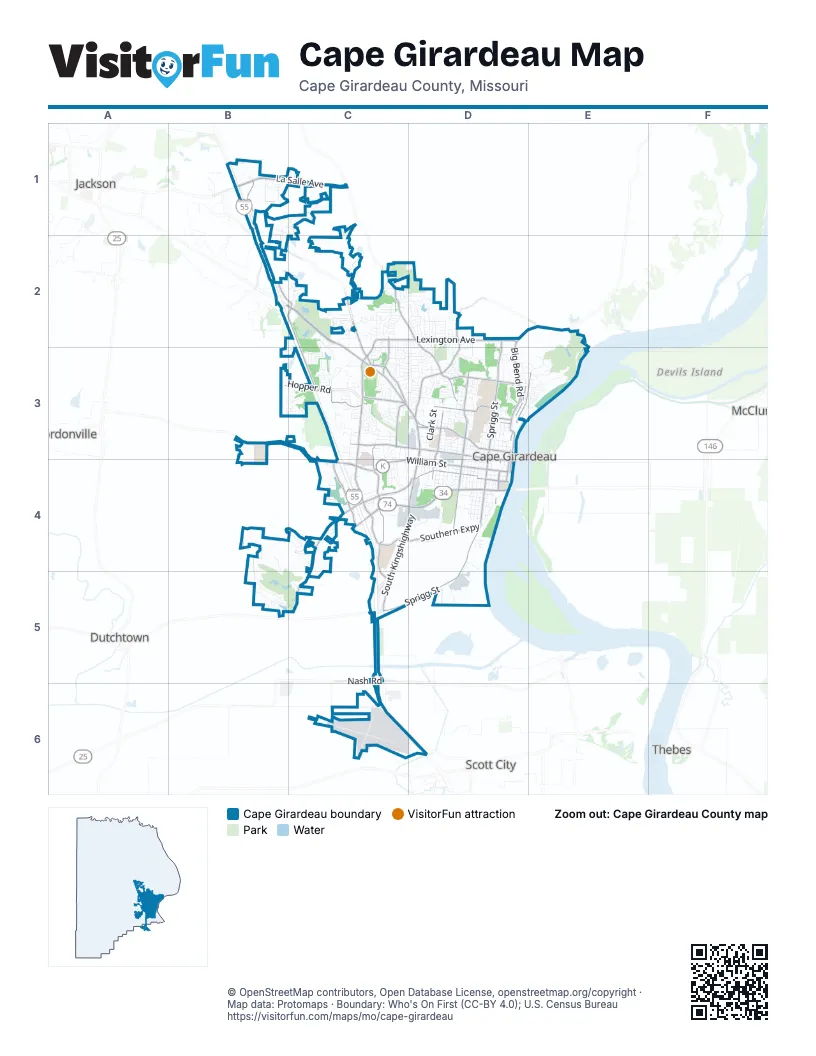
Street index of Cape Girardeau
Each street on the sheet and the grid squares it crosses.
- Shawnee ParkwayC4, D4
- North KingshighwayB2, C2, C3, D3
- South KingshighwayD3, C4, D4, C5
- William StreetC4, D4
- North Mount Auburn RoadC3, C4
- South Sprigg StreetD3, D4, C5, D5
- Lexington AvenueC2, D2, C3
- La Salle AvenueB1, C1
- Big Bend RoadD2, E2, D3
- North Sprigg StreetD2, D3
- Broadway StreetD3
- North Main StreetD3, E3, D4
- Mason StreetD3
- Nash RoadC5
- East Main StreetB1
- South Main StreetD4
- Chestnut StreetD3
- Independence StreetC3, D3, D4
- Perryville RoadC2, D2, D3
- Veterans Memorial DriveB1, B2, C2, C3
- South Silver Springs RoadC3, C4, C5
- Hopper RoadB3, C3
- Bloomfield RoadC4, D4
- South West End BoulevardD3, D4
- County Road 205C4, C5
- West Cape Rock DriveD2, D3
- Northwest Westend BoulevardD3
- Southern ExpresswayC4, D4
- Kingsway DriveC3, D3
- Bertling StreetD3
- Siemers DriveC4
- New Madrid StreetD3
- North Spanish StreetD3, D4
- East Rodney DriveC3
- Boutin DriveC2
- South Fountain StreetD4
- Cape la Croix RoadC2, C3
- Caruthers AvenueD3
- North Cape Rock DriveD3
- Morgan Oak StreetD4
- County Road 620B1, B2, C2
- Sheridan DriveD3, D4
- Rampart StreetC2, C3
- South Spanish StreetD4
- Olive StreetD3
- Kurre LaneC3
- South Old Orchard RoadB2
- County Road 306B1
- County Road 643E2
- Themis StreetC3, D3
- East Cape Rock DriveE2, E3
- Good Hope StreetD4
- North Henderson AvenueD3
- Old Sprigg Street RoadD2, D3
- South Pacific StreetD3, D4
- South Ellis StreetD3, D4
- South Benton StreetD3, D4
- Dalhousie DriveB5, C5
- Whitener StreetC3, D3
- Kenneth DriveC2
- County Road 206B3, B4, C4
- Sherwood DriveD2, D3
- College StreetD4
- County Road 618B1, C1
- Gordonville RoadC3, C4
- Walden BoulevardC2
- Clark StreetD3
- North Middle StreetD3, D4
- North Fountain StreetD3, D4
- Country Club DriveD3, E3
- Belleridge PikeC2, C3
- Kage RoadC3
- Airport RoadC5, C6
- Minnesota AvenueD3, D4
- Perry AvenueD3
- Giboney StreetD4
- Normal AvenueD3
- Jefferson AvenueD4
- Merriwether StreetD3, D4
- Lakewood DriveD2
- Bellevue StreetD3
- Elmwood LaneB4, B5, C5
- North Frederick StreetD3
- Dunklin StreetD3
- Farrar DriveC3, C4
- Greenbrier DriveC2, D2
- Brookwood DriveD3
- Edgewood RoadC3, C4
- South Broadview StreetC3, C4, D4
- South County Park RoadC2
- Grandview DriveC2, C3
- Hawthorne RoadC3
- North Water StreetD3, E3, D4
- Walnut StreetD4
- County Park DriveC2
- Randol AvenueD2, D3
- Kent DriveC2
- Commercial StreetD4
- Bessie StreetD3
- Langholm DriveB5
- Boulder Crest DriveC2
- North Missouri AvenueD3
- Rust AvenueD4
- Doctors ParkC4
- Cw Harris LaneC2
- MonterraB1, C1
- Melrose DriveC3, D3
- Cloverdale Ranch RoadB1, C1
- Aquamsi StreetD4
- County Road 203B4, C4
- Delwin StreetC2, C3
- South Hanover StreetD3, D4
- North Pacific StreetD3
- South Henderson AvenueD3, D4
- Fredrick StreetD3, D4
- Locust StreetD4
- Woodbine PlaceC3
- South Park AvenueD3, D4
- Westwood DriveD3
- Linden StreetD4
- Rusmar StreetD4
- Albert StreetD4
- Sylvan LaneD3
- North Broadview StreetD3
- Brucher DriveD3
- Corporate CircleD4
- El Rio DriveC2, D2
- Ranney AvenueD4
- Wilson RoadC4, D4
- County Road 208B4
- Richmond DriveC4
- Louis StreetD4
- Abbey RoadC2
- Rand StreetE3
- Luce StreetC3, D3
- Lasalle StreetC2
- Fairlane DriveD3
- Koch AvenueD4
- Percy DriveC3
- Janet DriveC3, D3
- Baldwin DriveB1
- North Sunset BoulevardD3
- Green Acres DriveD3, E3
- Elm StreetD4
- Commerce RoadD5
- North Lorimier StreetD3, D4
- West Rodney DriveC3
- Park AvenueD3
- Amblewood DriveD2, D3
- Rotary DriveD2, D3
- Steven DriveD2
- South Plaza WayD3, D4
- Kell Farm RoadC4
- Lakeshore DriveC2, D2
- North Spring StreetD3
- Kiwanis DriveC3, D3
- South Lake DriveC3
- Masters DriveC3, D3
- Minnesota StreetD4
- Parker DriveD3
- Patricia StreetC3
- Stoddard StreetD3
- Oak Lei DriveD3
- Brink AvenueD4
- Wolverine RoadC4
- Cambridge DriveD2
- Lacey StreetD3
- Camellia DriveC3, C4
- VantageC3, C4
- Maple StreetD4
- Lynnwood DriveC3, D3
- Thilenius StreetD3
- Lions Way DriveC3
- Saddle Ridge LaneC2
- Cobblestone CourtC4
- West ParkwayC4
- Capaha TrailE3
- South Lorimier StreetD4
- Beavercreek DriveC3
- Woodland Hills DriveD2
- Longview DriveC2, C3
- Limbaugh LaneC2
- Oak Hills DriveD3
- Julie DriveC3
- South Louisiana AvenueD3, D4
- North StreetD3
- Yorktown DriveD2
- Hackberry StreetD4
- Magnolia AvenueC3
- Cypress DriveD2
- Hunters LaneC2
- Pheasant Cove DriveC3
- Pemiscot StreetD3
- Scenic DriveC3
- Howell StreetD3
- Hickory StreetD4
- Stonebridge DriveC4
- Blattner DriveC4
- North Lake DriveC3
- Parksite DriveD2, D3
- South Middle StreetD4
- Lynwood Hills DriveC2
- Optimist DriveC3, D3
- Helmsdale DriveB5
- Montgomery StreetD4
- Chesapeake AvenueD2
- Timber Creek DriveD2, D3
- Carolina LaneC2, C3
- Silver Thorne TrailC2, C3
- Enterprise StreetC4
- Cardrona DriveB5
- Derbyshire LaneC2
- Albert Rasche DriveC3, D3
- Peach Tree StreetC3, D3
- Bristle RidgeB1, C1
- Lisa DriveC3, D3
- Shenandoah RidgeC3
- Washington AvenueD3
- Beaudean LaneD4
- North Ellis StreetD3
- North Louisiana StreetD3
- West Highland DriveC3
- Leroy DriveC3, D3
- Weissinger LaneD3
- Silverado TrailC1
- Wayne StreetD3
- Bel-Air DriveD3
- Briarwood DriveD2, D3
- David StreetC3
- Keystone DriveC3
- Earleen DriveC2
- Meadowbrook LaneC5
- Cape PlazaD3, D4
- Barberry StreetC4
- Marietta StreetD3
- Notre Dame DriveB3, B4
- Kingston AvenueB2, C2, B3, C3
- Ashland Hill DriveC3
- Maria Louise LaneC3, D3
- Garnet LaneB3, C3
- De Paul LaneE3
- Horseshoe RidgeC2
- Williamsburg DriveC2, D2
- Omaka SpringsB1, C1
- Wisteria DriveC3
- PennyD3
- Prospect DriveC2, C3
- Carolwood DriveC3
- Wolf LaneC4
- Transfer Street RoadD4, D5
- Whispering Oaks DriveB1, B2
- North Silver Springs RoadC3
- Roberts StreetD3, E3
- CheetahD2, D3
- Timon WayD3, E3
- Robin LaneC4
- Lombardo DriveD3
- South Spring StreetD4
- Rivercrest DriveE3
- Price DriveD3
- North Clark StreetD3
- Johnson StreetD3, E3
- Keller AvenueD3
- Copperfield RoadC4
- Paul Revere DriveC3
- Westridge DriveD3
- Pine Hill SpurC2
- La Mesa DriveC2
- South Missouri AvenueD4
- Briarcliff DriveD2, D3
- Greek DriveD3
- Shirley DriveC4
- Sussex DriveC2
- Petroleum RoadD4
- Cape Meadows CircleD3
- Dorothy StreetC3
- Otter LaneC5
- Woodlawn AvenueD3
- Landgraf DriveD3
- Springwood LaneC5
- Cousin StreetD4
- Pioneer DriveC4
- Ranchito DriveC3, D3
- Outer LaneC5
- Hillview StreetC4
- Bernice StreetD2
- Boxwood DriveC3
- Kage Hills DriveC3
- Limbaugh DriveC6
- Mimosa DriveC3
- Schonoff LaneC3
- Eden WayD3
- West DriveC3, C4
- East Lake DriveC3
- Hilldale CircleC3
- Melrose AvenueC3, D3
- 5th StreetD3, E3
- Business Park PlaceB1
- White Oaks LaneC5
- Christine StreetD4
Places on the map
- Abe Stuber Track
- Arena Park
- Buzzi Unicern
- Capaha Park
- Cape Girardeau Country Club
- Cape Girardeau County Memorial Cemetery
- Cape Girardeau County Park North
- Cape Girardeau County Park South
- Cape Girardeau Regional Airport
- Cape Jaycee Municipal Golf Course
- Cape Plaza
- Cape Rock
- Cape Rock Park
- Cape Splash
- Cape West
- Cape West Crossing
- Cape Woods Conservation Area
- Dalhousie Golf Club
- Doctors Park
- Fairmont Cemetery
- First Park West Plaza
- Galleria Plaza
- Golden Eagle Subdivision
- Independence Village
- Independence West Commons
- Jefferson Elementary School
- Kiwanis Park
- Little Bear Lake
- Menards
- Mercy Hospital Southeast
- Osage Park
- Park West Hospitality Center
- Riverfront Park
- Saint Francis Medical Center
- Shawnee Park
- Southeast Behavioral Hospital
- Southeast Health West Campus
- Southeast Missouri State University
- Twin Trees Park
- West Park Mall
Next to Cape Girardeau
- Dutchtown
- East Cape Girardeau
- Gordonville
- Jackson map
- McClure
- Scott City
- Thebes
© OpenStreetMap contributors, Open Database License, openstreetmap.org/copyright · Map data: Protomaps · Boundary: Who's On First (CC-BY 4.0); U.S. Census Bureau















