

Missouri map
Clay County map
About 263,370 people live here (Census Bureau, 2024 estimate). The sheet's index lists 87 streets; Chicago-Kansas City Expressway, Arrowhead Trafficway and North Oak Trafficway cross the most grid squares. Things to do inside the boundary: American Inn North Kansas City, Comfort Inn & Suites Kansas City - Northeast and Jesse James Birthplace.
Open the map (PDF, US Letter)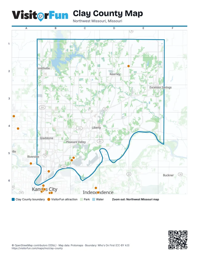
Street index of Clay County
Each street on the sheet and the grid squares it crosses.
- Chicago-Kansas City ExpresswayD1, D2, C3, D3, C4, C5
- Clevelend StreetD1
- Northeast 192nd StreetF1
- West 6th StreetF1, D2
- North Jefferson StreetD2
- South Jefferson StreetD2, D3
- West 19th StreetD2
- North Jesse James RoadE2, E3
- Northwest Cookingham DriveA3, B3
- Northwest Shoal Creek ParkwayA3, B3
- Arrowhead TrafficwayB3, A4, B4, A5
- Maplewoods ParkwayB3, B4
- North Oak TrafficwayB3, B4, B5, B6
- North Woodland AvenueB3
- Northeast 108th StreetB3, C3
- Northeast Cookingham DriveB3, C3, C4
- Northeast Shoal Creek ParkwayB3, B4, C4
- Lightborne RoadC3
- Lightburne StreetC3, C4
- North Church RoadC3, C4, C5
- Plattsburg RoadC3
- Kearney RoadE3
- Old Orchard AvenueE3
- Saint Louis AvenueE3, F3
- Sycamore StreetE3
- West Jesse James RoadE3
- Isley BoulevardF3
- Alexander Doniphan Memorial HighwayA4, B4, C4
- North Platte Purchase DriveA4
- Northwest Barry RoadA4, B4
- North Brighton AvenueB4, B5, B6
- North Broadway AvenueB4, B5
- North Indiana AvenueB4
- North M1 HighwayB4
- North Prospect AvenueB4, B5
- Northeast 72nd StreetB4
- Northeast 96th StreetB4, C4
- Northeast Barry RoadB4, C4
- Northwest 72nd StreetB4
- Searcy Creek ParkwayB4, B5
- Conistor StreetC4
- East Mill StreetC4
- Forest LaneC4
- Glenn Hendren DriveC4
- Liberty DriveC4, C5
- Nashua RoadC4
- NE Barry RoadC4
- North Flintlock RoadC4, C5
- North Gallatin StreetC4
- Richard L. Harriman HighwayC4, D4
- South Gallatin StreetC4
- South Leonard StreetC4
- South Ridge AvenueC4
- South Withers RoadC4, C5
- Sunset AvenueC4
- West Kansas StreetC4
- West Liberty DriveC4
- West Mill StreetC4
- Northwest 68th StreetA5, B5
- Northwest Briarcliff ParkwayA5, B5
- Northwest Englewood RoadA5, B5
- Northwest Platte RoadA5
- Northwest Vivion RoadA5, B5
- Lewis & Clark TrailB5, C5
- North Antioch RoadB5
- North Chouteau TrafficwayB5, B6
- Northeast 42nd StreetB5
- Northeast Antioch RoadB5
- Northeast Briarcliff ParkwayB5
- Northeast Chouteau ParkwayB5, B6
- Northeast Chouteau TrafficwayB5
- Northeast Englewood RoadB5
- Northeast Parvin RoadB5, C5
- Northeast Pleasant Valley RoadB5, C5
- Northeast Prather RoadB5, B6
- Northeast Vivion RoadB5
- Lamar Hunt Memorial HighwayC5
- North Randolph RoadC5
- South Liberty ParkwayC5, D5
- Worlds of Fun DriveC5
- John Jordan "Buck" O'Neil Memorial BridgeA6
- Armour RoadB6
- Burlington StreetB6
- East 16th AvenueB6
- Heart of America BridgeB6
- Linn StreetB6
- Vernon StreetB6
Things to do on the Clay County map
Places on the map
- 97 at North Oak Apartments
- Adam Acres
- AJ Wilson Sports Complex
- Allen Heights
- Amazon Fulfillment Center MCI3
- Amber Lakes
- Amber Meadows
- Ameristar Casino Kansas City
- Anita B. Gorman Park
- Anne Garney Park
- Antioch Crossings
- Antioch Gardens
- Antioch Hiland Acres
- Antioch Hills
- Applewood Farms
- Appling Heights
- Arbor Mist Townhomes
- Armour Place
- Ashley Acres
- Auburn Hills
- Auburndale Estates
- Auburndale Manor
- Auburndale Patio Homes
- Aull Acres
- Avondale
- Bad Rock Creek Disc Golf Course
- Baldwin Hills
- Ballybrook Acres
- Ballybrook Estates
- Bar J Estates
- Barnes Addition
- Barrewoods Apartments
- Barrington Ridge
- Barry Pointe Office Park
- Barry Woods
- Barrybrooke
- Barway Plaza
- Beacon Hill
- Beason's Meadow
- Bedford Downs
Next to Clay County
- Buckner
- Independence
- Kansas City map
- Riverside
© OpenStreetMap contributors (ODbL) · Map data: Protomaps · Boundary: Who's On First (CC-BY 4.0)