

Missouri map
Independence map
About 121,629 people live here (Census Bureau, 2024 estimate). The sheet's index lists 300 streets; East Truman Road, South Little Blue Parkway and Truman/Eisenhower Presidential Highway cross the most grid squares. Things to do inside the boundary: Harry S. Truman Presidential Library and Museum and Midwest Genealogy Center.
Open the map (PDF, US Letter)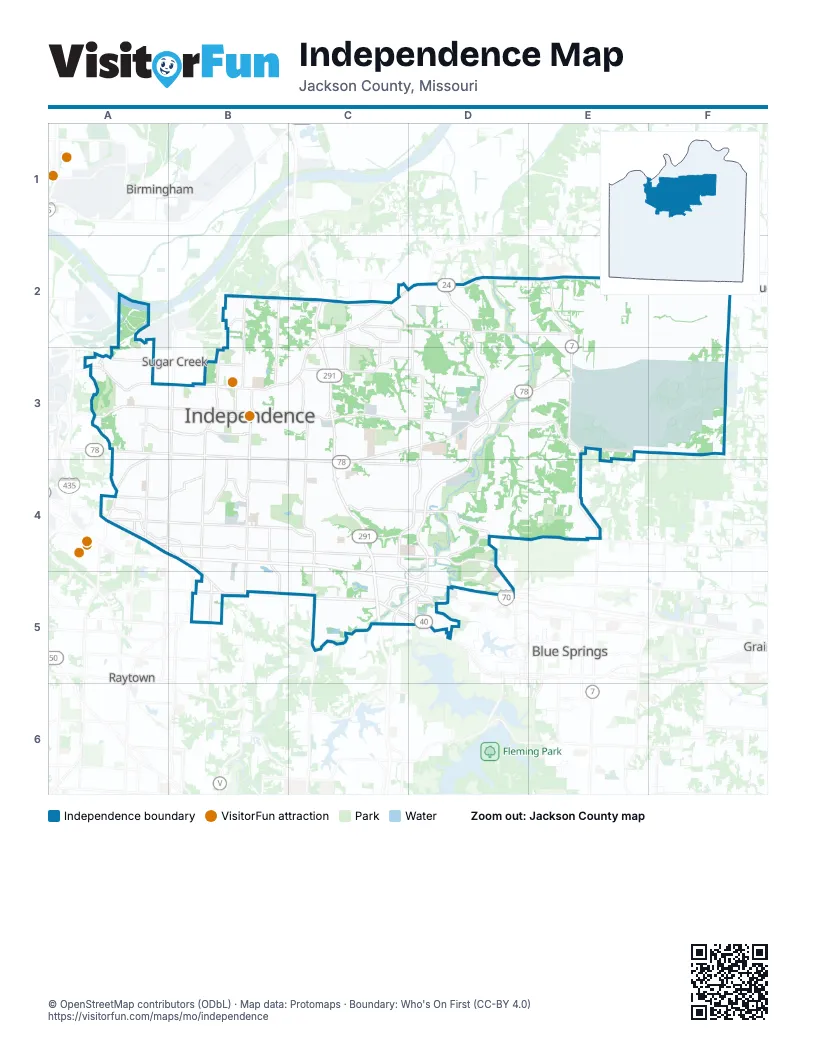
Street index of Independence
Each street on the sheet and the grid squares it crosses.
- Truman/Eisenhower Presidential HighwayB4, C4, C5, D5
- Clifton J. Scott Memorial HighwayB4, C4
- Dwight D. Eisenhower HighwayD5
- South Little Blue ParkwayD2, D3, D4, C5, D5
- Corporal M.E. Webster Memorial ParkwayC5, D5
- South Noland RoadB3, B4, B5
- East 23rd Street SouthA3, B3, B4, C4
- East Winner RoadA3, B3
- North Noland RoadB3
- East US Highway 40A4
- West 23rd Street SouthB3
- Lake City - Buckner RoadE3, F3
- West US Highway 24B3
- East 23rd TrafficwayA3
- West 24 HighwayB3
- Winner RoadA3
- East Truman RoadA3, B3, C3, D3, E3, F3
- East 39th Street SouthA4, B4, C4, D4
- East Bundschu RoadC2, D2, E2, F2
- South Jackson DriveD3, C4, D4
- East 35th Street SouthA4, B4, C4
- South Crysler AvenueB3, B4, B5
- South Sterling AvenueB3, A4, B4
- Blue Ridge BoulevardA3, A4, B4
- East Kentucky RoadB2, C2, A3
- East 39th StreetC4, D4
- East Salisbury RoadB3, C3, D3
- East R.D. Mize RoadC4, D4
- Holke RoadD3, C4, D4
- Lee's Summit RoadC3, C4
- South Lee's Summit RoadC4, C5
- North River BoulevardB3
- West Lexington AvenueB3
- North Lee's Summit RoadC3
- Northwest Pink Hill RoadD4, E4
- Northwest R.D. Mize RoadD4, D5
- West Truman RoadB3
- North Jones RoadD2, D3
- South Jones RoadD3
- East 47th Street SouthB5
- North Jackson DriveC2
- East Hidden Valley RoadC4
- Kentucky RoadC2, A3
- East Jones RoadB3, D3
- Blue Ridge CutoffA4
- Northwest Woods Chapel RoadD5
- South R.D. Mize RoadD4
- Northwest Duncan RoadD5
- Northwest Jefferson RoadD5
- South Hardy AvenueA3, A4
- East Valley View ParkwayC5, D5
- North Liberty StreetB2, B3
- East 31st Street SouthA4, B4, C4
- South Norwood AvenueB3, B4
- South Ash AvenueA3, A4
- Dickinson RoadB2, B3
- South Main StreetB3, B4, B5
- South Osage AvenueB3, B4, B5
- North Spring StreetB2, B3
- South Phelps RoadB4, B5
- South Westport RoadA3, A4
- East Wilson RoadA3
- East Pacific AvenueB3, C3
- Susquehanna RidgeC2
- East Jackson DriveC4, C5, D5
- Cheyenne DriveC2, C3
- South Maywood AvenueA3, A4
- South Mc Coy StreetB3, B4, B5
- East Pink Hill RoadD4
- South Kentucky AvenueA3
- East Gudgell StreetB4, C4
- North Jennings RoadC2, C3
- East 18th StreetA3
- Norfleet RoadB5
- East Lexington AvenueB3
- South Santa Fe RoadB4
- North Ponca DriveC2, C3
- East Sheley RoadA4, B4
- West Pacific AvenueB3
- Northwest Valley View RoadD5
- Kings HighwayB3, B4
- West Jones RoadB3
- Colonel DriveB2
- South Sheley RoadA4, B4
- West Sheley RoadB4
- South Valley View RoadD5
- Pittman RoadA4
- South Kentucky RoadA3
- North Courtney RoadB2
- West Elm StreetB3
- West Gudgell AvenueB4
- Salem DriveC2, D2
- Northeast Lakewood WayC5
- Heartland AvenueD5
- West 33rd StreetB4
- East 18th Street NorthC2
- Whitney RoadC2
- East 31 Street SouthA4
- North Northwest ParkwayB3
- North Blue Mills RoadD2
- Lake City RoadF2, E3, F3
- Commander's RidgeE3
- South Northern BoulevardA3, A4
- East 43rd Street SouthB4, B5, C5
- South Scott AvenueB3, B4
- South Crenshaw RoadD3, D4
- South Claremont AvenueB3, B4
- South Vermont AvenueB3, B4
- East 41st Street SouthB4, C4
- South Overton AvenueA3, A4
- East Heidelberger RoadE3, F3
- South Cedar AvenueA3, A4
- East 34th Street SouthA4, B4, C4, D4
- South Pleasant StreetB3, B4, B5
- East Strode RoadD4, E4
- North Powell RoadD2, D3
- South Harris AvenueA3, B3, A4
- Owens School RoadE3
- East 32nd StreetA4, B4, C4, E4
- North Lake City Valley RoadF2, E3
- East 33rd StreetA4, B4, C4
- East 9th Street SouthA3, B3, C3, D3
- North Elsea Smith RoadE2, E3
- Ellison WayC3, C4
- North Osage StreetB2, B3
- South Liberty StreetB3, B4, B5
- South Powell RoadD3
- South Spring StreetB3, B4, B5
- Crackerneck RoadC4
- South Glenwood AvenueA3, A4
- South Hawthorne StreetA3, A4
- South Arlington AvenueA3, A4
- South Crane StreetB3, B4
- East 44th Street SouthB5, C5
- East R D Mize RoadC4
- South Brookside AvenueA3, A4
- East 15th Street SouthA3, B3, C3, D3
- South Leslie StreetB3, B4
- North Pleasant StreetB2, B3
- Independence Center DriveC4, C5
- East Sea AvenueB3, C3
- East 42nd Street SouthB4, C4, C5, D5
- Necessary RoadD4
- East 25th StreetA4, B4, C4
- East 36th Street SouthA4, B4, C4
- South Home AvenueA3, A4
- East 20th StreetA3, B3
- East 37th Terrace SouthB4, C4
- Appleton AvenueA3, A4
- South Forest AvenueB3, B4
- South Pearl StreetB3, B4
- South Delaware AvenueB3, B4, B5
- South Evanston AvenueA3, A4
- South Grand AvenueB3, B4, B5
- South Selsa RoadD4
- South Willis AvenueB3, B4, B5
- North Delaware StreetB2, B3
- East Independence AvenueA3, C3
- Shrank RoadC4
- South Ralston AvenueA3, A4
- East 30th Terrace SouthA4, B4, C4, E4
- Allen RoadC2
- East 29th StreetA4, B4, C4
- East 40th StreetB4, C4
- East 25th Terrace SouthA4, B4, C4
- South Fuller StreetB3, B4, B5
- Redwood DriveC2, C3, C4
- Harvard AvenueA3, B3, A4
- West Maple AvenueB3
- Queen Ridge DriveC3, C4
- East 14th Street NorthC2, D2
- South Osage StreetB3, B4
- East 39th Terrace SouthB4, C4
- East 40th Terrace SouthB4, C4
- North Union StreetB2, B3
- North Ferguson Spring RoadD2
- East 41st Terrace SouthB4, C4, C5, D5
- East South AvenueB3, C3
- South Emery StreetB3, B4
- East 42nd Terrace SouthB4, C4, C5, D5
- West College AvenueB3
- East 27th StreetA4, B4
- T C Lea RoadB3, C3
- West Walnut StreetB3
- South Crescent AvenueA3, A4
- North Main StreetB3
- North Kiger RoadC3
- South Pope AvenueB3, B4
- North Mc Coy StreetB2, B3
- South Swope DriveC3, C4
- South Norton AvenueB3, B4
- West Linden AvenueB3
- East 19th Street SouthA3, B3, C3
- South Trail Ridge DriveC3, C4
- South Hocker StreetB4, B5
- West South AvenueB3
- South Ringo RoadC4
- South Bolger DriveC4
- East 35th Terrace SouthA4, B4, C4
- South River BoulevardB3, B4, B5
- South Dodgion AvenueB3, B4
- South Hedges StreetA3, A4
- Castle DriveC4, D4
- East 37th Terrace Court SouthB4, C4, D4
- Bass Pro DriveC5
- South Van Dyke RoadF3
- South Arlington StreetA3
- North Burnley RoadF2, F3
- East 28th Street SouthA4, C4
- East 16th StreetA3, B3, C3
- North Winfrey RoadF2
- North Charlton RoadE2
- Scarritt AvenueA3
- Old Highway 291C2
- Phillips RoadF3
- South Union StreetB3, B4, B5
- South Hocker AvenueB3, B4
- East 28th Terrace SouthA4, C4
- South Cottage AvenueB4, B5
- East 36th Terrace SouthA4, B4, C4
- Cedar Crest DriveC4, C5
- East 24th StreetA3, A4, B4, C4
- Carswell RoadF2
- East 38th Street SouthB4, C4
- Seminole DriveC2, C3, C4
- West White Oak StreetB3
- South Bass Pro DriveC5
- South Tierney DriveC5
- East Hayward StreetB3, C3
- East 46th Street SouthB5, C5
- East 40th Street SouthB4, C4
- East 43rd Terrace SouthB5, C5
- East 37th Street SouthB4, C4
- West 27th StreetB4
- East 37th Street NorthB2, B4
- East 52nd Street SouthB5, C5
- Englewood TerraceB3, B4
- North Lynn StreetB3
- East 14th StreetA3, B3
- Sioux AvenueD2, C3, C4
- East College StreetB3
- East Kansas AvenueB3, C3
- South Adams AvenueB4
- East 38th Terrace SouthA4, B4, C4
- Lobb Cemetery RoadE4
- East 45th Terrace SouthB5, C5
- North Bly RoadD2, D3
- East Mechanic AvenueB3, C3
- East 45th Street SouthB5, C5
- East 31st Terrace SouthC4, E4
- East Walnut AvenueB3, C3
- East 6th Street NorthC3, D3
- South Park AvenueB3, B4
- East 27th Terrace SouthA4, C4
- East 51st StreetB5
- North Rogers StreetB3, C3
- South Willow AvenueA3, A4
- Swope DriveC2
- Crisp AvenueB3, B4
- East Linwood BoulevardA4
- James Downey RoadC3, C4
- East 32nd Street SouthB4
- South Huttig AvenueA3
- Burgess RoadF3
- Speck RoadC3, C4
- East 10th StreetA3, B3, C3
- East Mayes RoadB3, C3
- South Bryn Mawr DriveC4
- South Milton DriveC4, C5
- South Dodgion StreetB3, B4
- East 12th Terrace NorthB2, C2, D2
- Lexington AvenueA3, B3
- East 28th TerraceA4, C4
- South Queen Ridge DriveC4
- East 2nd Street SouthC3, D3
- Lacy RoadC3
- East Eureka RoadD4
- Lake DriveA3, B4
- Millhaven StreetD2
- East 49th TerraceB5
- South Lynn StreetB3, B4
- South Maybrook AvenueC4
- North Old Mill RoadD2, D3
- East Walnut StreetB3
- South Marion AvenueB3, B4, B5
- Bess Truman ParkwayB3
- West Waldo StreetB3
- Viking DriveC3, C4
- Atherton RoadC2
- East 17th StreetA3, B3, C3
- Norledge StreetA3
- East 30th StreetA4, B4, C4
- South Woodland AvenueB3, B4
- Dakota DriveC2, C3
- South Whitney AvenueC4
- Shady Bend DriveB4
- Washington AvenueB4, B5
- North Crysler StreetB3
- South Haden DriveC4
- East 49th Street SouthB5
Things to do on the Independence map
Places on the map
- Adair Park
- Beckett Park
- Bingham Middle School
- Bingham-Waggoner Estate
- Blackburn Elementary School
- Blackburn School Park
- Bolger Square
- Bullhead Lake
- Bundschu Park
- Campus Park
- Cargo Largo
- Centerpoint Medical Center
- Children's Mercy East
- Choplin-Hood Park
- Chrisman Plaza
- Cler-Mont Elementary School
- Congo
- Crossroads
- Drumm Farm Center for Children
- Drumm Farm Golf Club
- Future Eastgate Commerce Center
- George Owens Nature Park
- Harry S Truman Historic District
- Independence Athletic Complex
- Independence Center
- Independence Square
- Lake City Army Ammunition Plant
- Lipton Conservation Area
- Little Blue Trace Nature Preserve
- Mill Creek Park
- Mount Washington Cemetery
- Noland Fashion Square
- Rockwood Golf Club
- Santa Fe Trail Park
- Stone Canyon Golf Club
- Truman High School
- Van Hook Park
- Winterstone Golf Course
- Woodlawn Cemetery
Next to Independence
- Birmingham
- Blue Springs map
- Lake Tapawingo
- Raytown map
- Sugar Creek
© OpenStreetMap contributors, Open Database License, openstreetmap.org/copyright · Map data: Protomaps · Boundary: Who's On First (CC-BY 4.0); U.S. Census Bureau















