

Missouri map
Kansas City map
About 516,032 people live here (Census Bureau, 2024 estimate). The sheet's index lists 13 streets; Arrowhead Trafficway, Alexander Doniphan Memorial Highway and George Brett Super Highway cross the most grid squares. Things to do inside the boundary: American Jazz Museum, Arabia Steamboat Museum and Arrowhead Stadium.
Open the map (PDF, US Letter)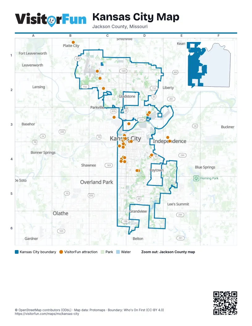
Street index of Kansas City
Each street on the sheet and the grid squares it crosses.
- Northwest Cookingham DriveB1, C1
- Arrowhead TrafficwayC1, C2, C3
- Alexander Doniphan Memorial HighwayB2, C2, D2
- George Brett Super HighwayC3, D3, D4
- Harry Darby Memorial HighwayC3
- Jay B. Dillingham FreewayC3
- John Jordan "Buck" O'Neil Memorial BridgeC3
- Lewis and Clark ViaductC3
- Truman/Eisenhower Presidential HighwayC3, D4
- Bruce R. Watkins DriveD3, D4, D5
- Lamar Hunt Memorial HighwayD3, D4
- Askew AvenueD4
- Blue ParkwayE5
Things to do on the Kansas City map
- American Jazz Museum
- Arabia Steamboat Museum
- Arrowhead Stadium
- Arthur Bryant's Barbeque
- Best Western Plus Kansas City Airport-KCI East
- Boulevard Brewing Co. Tours & Rec Deck
- City Market
- College Basketball Experience
- Comfort Inn & Suites Kansas City - Northeast
- Country Club Plaza
- Crown Center
- Drury Inn & Suites Kansas City Airport
- Just One Day Travel Tours
- Kansas City Helicopter Tours
- Kansas City Power & Light District
- Kansas City Zoo & Aquarium
- Kauffman Center for the Performing Arts
- Kauffman Stadium
- KC Streetcar
- KC Visitor Center
- Kemper Museum of Contemporary Art
- La Quinta Inn & Suites by Wyndham Kansas City Airport
- Legoland Discovery Center Kansas City
- Loose Park
- National Museum of Toys and Miniatures
- National WWI Museum and Memorial
- Negro Leagues Baseball Museum
- Nelson-Atkins Museum of Art
- Royals Hall of Fame
- Starlight Theatre
- TerraVox Winery
- The Money Museum at the Federal Reserve Bank of Kansas City
- Union Station Kansas City
- Worlds of Fun
Places on the map
- Airworld Center
- Amber Lakes
- Amber Meadows
- Armour Hills
- Ashland Ridge
- Auburndale Estates
- Bannister Acres
- Benson Place
- Benson Place Fieldstone
- Berlin Reservoir
- Big Blue Battlefield Park
- Big Shoal Greenway
- Birchwood Hills
- Blue Hills Country Club
- Blue River
- Blue River Commerce Center
- Blue Valley Park
- Blue-Vue Hills
- BNSF 19th Street Yard
- Breen Hills
- Brentwood Crossing
- Briarcliff Hills
- Briarcliff West
- Bridge Pointe
- Bridlespur
- Broadland
- Brooke Ridge
- Brush Creek Parkway
- Cadence
- Camp Prairie Schooner
- Canterbury Estates
- Carriage Hill Estates
- CenterPoint Intermodal Center
- Cerner Innovations Campus
- Charleston Harbor
- Citadel
- Claymont North
- Clayton
- Clayton Meadows
- Congress Corporate Center
Next to Kansas City
- Basehor
- Belton
- Blue Springs
- Bonner Springs
- Buckner
- De Soto
- Edwardsville
- Excelsior Springs
- Fort Leavenworth
- Gardner
- Gladstone
- Grain Valley
- Grandview
- Independence
- Kearney
- Lansing
- Leavenworth
- Leawood
- Lee's Summit
- Lenexa
- Liberty
- Merriam
- Olathe
- Overland Park
- Parkville
- Platte City
- Pleasant Valley
- Raymore
- Raytown
- Riverside
- Shawnee
- Smithville
© OpenStreetMap contributors (ODbL) · Map data: Protomaps · Boundary: Who's On First (CC-BY 4.0)