

Missouri map
St. Louis map
About 279,695 people live here (Census Bureau, 2024 estimate). The sheet's index lists 128 streets; Arsenal Street, Gravois Avenue and South Broadway cross the most grid squares. Things to do inside the boundary: Anheuser-Busch Brewery Tour, Busch Stadium and Busch Stadium Tours & Cardinals Hall of Fame Museum.
Open the map (PDF, US Letter)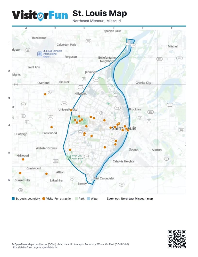
Street index of St. Louis
Each street on the sheet and the grid squares it crosses.
- Riverview DriveD1, D2
- Southeast Chambers RoadD1
- New Chain of Rocks BridgeE1
- Goodfellow BoulevardC2, D2, C3
- Mark Twain ExpresswayC2, C3, D3
- Riverview BoulevardC2, D2, C3
- Saloma AvenueC2
- West Florissant AvenueC2, D3
- Woodland AvenueC2
- Bellefontaine RoadD2
- Hall StreetD2, D3
- Halls Ferry CircleD2
- Halls Ferry RoadD2
- Lewis and Clark BoulevardD2
- North BroadwayD2, D3, D4
- Bircher BoulevardC3, D3
- DeBaliviere AvenueC3, C4
- Delmar BoulevardC3, C4, D4
- Doctor Martin Luther King DriveC3, D4
- Express LaneC3, D3, D4
- Kienlen AvenueC3
- Natural Bridge AvenueC3, D3
- Natural Bridge RoadC3
- North Kingshighway BoulevardC3, D3, C4
- North Skinker BoulevardC3, C4
- Olive BoulevardC3
- Page BoulevardC3, D4
- Union BoulevardC3, D3, C4
- Adelaide AvenueD3
- Andy Gammon Memorial HighwayD3, D4
- Carrie AvenueD3
- East Grand AvenueD3
- McKinley BridgeD3
- North 11th StreetD3
- North 9th StreetD3
- North Florissant AvenueD3, D4
- North Grand BoulevardD3, D4
- North Vandeventer AvenueD3, D4
- Palm StreetD3
- Parnell StreetD3, D4
- Salisbury StreetD3
- Von Phul StreetD3
- Arsenal StreetB4, C4, C5, D5
- Daniel Boone ExpresswayB4
- Ellendale AvenueB4, B5
- Jack Buck Memorial HighwayB4, C4, D4
- Jamieson AvenueB4, B5, C5
- Manchester AvenueB4, C4
- Manchester RoadB4
- McCausland AvenueB4, C4
- Southwest AvenueB4, C4
- Chouteau AvenueC4, D4
- Clayton RoadC4
- De Tonty StreetC4
- Forest Park AvenueC4, D4
- Forest Park ParkwayC4
- Forsyth BoulevardC4
- Hampton AvenueC4, C5
- Ivanhoe AvenueC4
- Lindell BoulevardC4, D4
- McRee AvenueC4
- Officer David Haynes Memorial HighwayC4, D4
- Officer Michael Barwick Memorial HighwayC4, B5, C5
- Shaw BoulevardC4
- South Kingshighway BoulevardC4, C5
- South Skinker BoulevardC4
- South Vandeventer AvenueC4, D4
- Watson RoadC4, C5
- Bernard StreetD4
- Cass AvenueD4
- Cole StreetD4
- Congressman William L. Clay Sr. BridgeD4
- Convention PlazaD4
- Doctor Martin Luther King BridgeD4
- Eads BridgeD4
- Geyer AvenueD4
- Gravois AvenueD4, C5, D5, C6
- Lumiere Place BoulevardD4
- Market StreetD4
- Memorial DriveD4
- North 13th StreetD4
- North 14th StreetD4
- North 4th StreetD4
- North Compton AvenueD4
- North Jefferson AvenueD4
- North Service RoadD4
- North Tucker BoulevardD4
- Olive StreetD4
- Ozark ExpresswayD4, D5
- Russell BoulevardD4, D5
- South 14th StreetD4
- South 18th StreetD4
- South 4th StreetD4
- South 7th StreetD4, D5
- South 8th StreetD4
- South BroadwayD4, D5, C6, D6
- South Compton AvenueD4, D5
- South Grand BoulevardD4, C5, D5
- South Jefferson AvenueD4, D5
- South Service RoadD4
- South Tucker BoulevardD4
- Stan Musial Veterans Memorial BridgeD4
- Third Street ExpresswayD4
- Truman ParkwayD4
- Washington AvenueD4
- Washington BoulevardD4
- Chippewa StreetB5, C5, D5
- Lansdowne AvenueB5, C5
- River Des Peres BoulevardB5, C5, C6
- Wabash AvenueB5
- Weil AvenueB5
- Wellington AvenueB5
- Bates StreetC5, D6
- Germania StreetC5, C6
- Loughborough AvenueC5, C6
- Michigan AvenueC5, C6
- Morganford RoadC5, C6
- Virginia AvenueC5, C6
- Alabama AvenueC6
- Carondelet BoulevardC6
- Gravois RoadC6
- Idaho AvenueC6
- Ivory StreetC6
- Lemay Ferry RoadC6
- Marceau StreetC6
- River City BoulevardC6
- River City Casino BoulevardC6
- South Broadway StreetC6
Things to do on the St. Louis map
- Anheuser-Busch Brewery Tour
- Busch Stadium
- Busch Stadium Tours & Cardinals Hall of Fame Museum
- Cathedral Basilica of Saint Louis
- Cherokee Street
- City Museum
- Federal Reserve Bank of St. Louis
- Forest Park
- Gateway Arch National Park
- Mama's On The Hill
- Missouri Botanical Garden
- Missouri History Museum
- Residence Inn St. Louis Downtown
- Riverboats at the Gateway Arch
- Saint Louis Art Museum
- Saint Louis Science Center
- Saint Louis Zoo
- Soulard Farmers Market
- St. Louis Aquarium at Union Station
- St. Louis Central Library
- Ted Drewes Frozen Custard
- The Fabulous Fox Theatre
- The Hill
- The Muny
- World Chess Hall of Fame
Places on the map
- Academy
- Acme Heights
- Ameren Headquarters
- Anheuser-Busch Brewery
- Aubert Place
- Austria Heights
- Baden
- Barnes-Jewish Hospital
- Bell Place
- Bellefontaine Cemetery
- Benton Park
- Benton Park West
- Benton Place
- Bevo Mill
- Bircher Place
- Boeing Aviation Fields
- Botanical Heights
- Boulevard Heights
- Burgen Place
- Calvary Cemetery
- Calvary Cemetery Prairie
- Carondelet
- Carondelet Gardens
- Carondelet Hills
- Carondelet Park
- Carondelet Park View
- Carr Square
- Carr Square Village
- Catlin Tract
- Central West End
- Chatsworth
- Cheltenham
- Cherokee Street
- Chester Heights
- Chippewa Hills
- Chippewa Park
- Christy Park
- City Foundry
- City Plaza
- Classics of Eads Park
Next to St. Louis
- Affton
- Alorton
- Bel-Nor
- Bellefontaine Neighbors
- Brentwood
- Bridgeton
- Brooklyn
- Cahokia Heights
- Calverton Park
- Charlack
- Clayton
- Country Club Hills
- Crestwood
- East Carondelet
- East Saint Louis
- Edmundson
- Ferguson
- Glasgow Village
- Granite City
- Hazelwood
- Hillsdale
- Huntleigh
- Jennings
- Kinloch
- Kirkwood
- Lakeshire
- Lemay
- Mitchell
- Overland
- Saint Ann
- Saint George
- Sauget
- Spanish Lake
- Sunset Hills
- University City
- Velda City
- Vinita Park
- Webster Groves
- Wilbur Park
© OpenStreetMap contributors (ODbL) · Map data: Protomaps · Boundary: Who's On First (CC-BY 4.0)