

Missouri map
Stone County map
About 32,630 people live here (Census Bureau, 2024 estimate). The sheet's index lists 300 streets; Main Street, Pine Street and Welch Road cross the most grid squares. Things to do inside the boundary: Silver Dollar City, Dogwood Canyon Nature Park and Table Rock Lake.
Open the map (PDF, US Letter)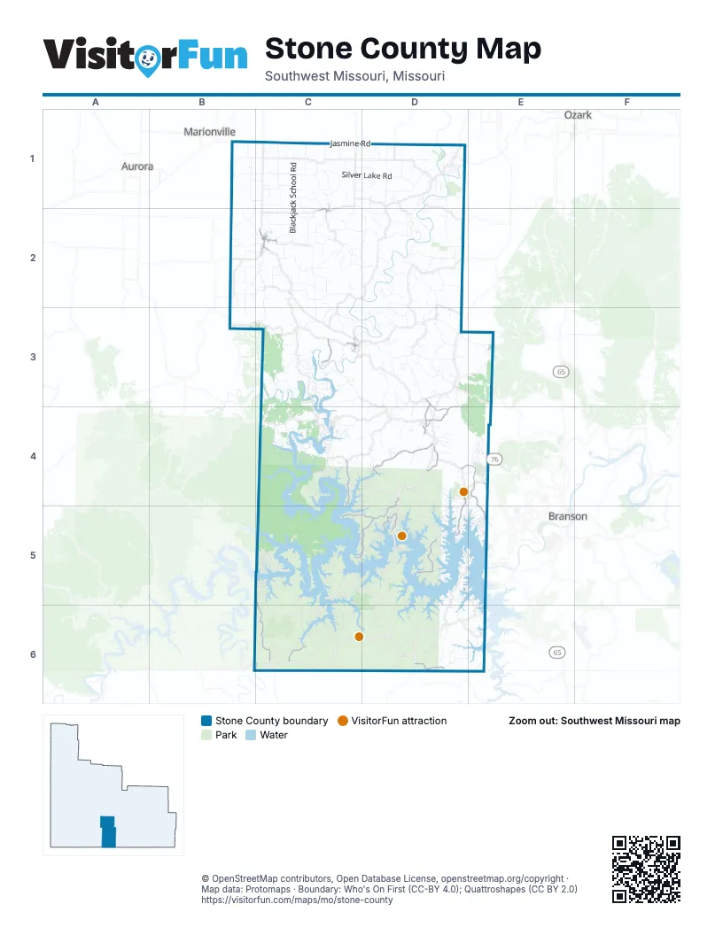
Street index of Stone County
Each street on the sheet and the grid squares it crosses.
- Ozark Mountain HighroadE4
- Jasmine RoadB1, C1, D1
- South Commerce StreetC2
- West Rose AvenueC2
- West 76 Country BoulevardE4
- North Commerce StreetC2
- State Highway 39C5, C6
- Old Wilderness RoadD3, D4
- State Highway 265E4, E5
- Main StreetC2, D3, D4, D5
- Spring StreetD3, D4
- West 3rd StreetC3
- West Meadow AvenueC2
- Old Highway 13C3
- Ance Creek RoadD4
- Joe Bald RoadC5, D5
- Indian Point RoadD4, D5
- State Highway DDD5
- Pioneer Point RoadC4, C5
- Little Aunts Creek RoadC5, D5
- Stonebridge ParkwayD4, E4
- Lakeshore DriveC5, D5, E5
- State Highway EED6
- Business 13D4
- McCord Bend RoadC3
- James River RoadD4, D5
- Washington RoadC6
- Kimberling BoulevardD5
- Pine StreetC2, C3, D5, E5
- South Maple StreetC3, D5
- West Main StreetC2
- Morrill LaneD4
- Madison AvenueC2
- Pirate LaneC2
- East Meadow AvenueC2
- South Walnut StreetC2, D5
- South Main StreetC3
- East 5th StreetC3
- West Lockhart StreetC2
- East AvenueC2
- Creek AvenueC2
- East Main StreetC2
- East 4th StreetC3
- Middle School Entrace from 413D4
- South Nicholas RoadD1
- Stallion Bluff RoadC4, C5
- Flat Creek RoadC3, C4
- Silver Lake RoadC1, D1
- Shiloh Church RoadC1
- Keystone RoadD3, D4, E4
- Blackjack School RoadC1, C2
- Swinging Bridge RoadC2
- Railey Creek RoadD3
- Hendrickson School RoadC5, C6
- Warner RoadD2
- Talking Rocks RoadD4, D5
- Wheeler Branch RoadC2
- Dogwood Tree RoadD3
- Peninsula DriveC5
- Old Highway 160D3
- Red Hill DriveB2, C2, B3
- Pleasant View RoadD2
- Quail Spur RoadC2
- Tilden RoadC3
- Pleasant Valley DriveD2
- Longbend RoadC4
- Bluff RoadC2, D2
- Kimberlin Mill RoadD1
- Buttermilk Spring RoadC4, C5
- Wilson Creek RoadD3, D4
- Lane Branch RoadC1, C2
- Johnson Rowe DriveD2, D3
- Possum Trot RoadD1
- Bread Tray Mountain RoadC5
- Horsecreek RoadC3, D3
- Holt Woods RoadD3
- Crumpley DriveC1
- Cave Spring RoadC2, C3
- Coon Ridge RoadD3
- Nauvoo RoadC6
- Stone County RoadC3, C4
- Camp Clark HillC3
- Mural RoadC2
- Camp Youcum RoadC3, D3
- 39-1-MC4, C5
- The Loop RoadD1, D2
- Pokeberry LaneD5
- Holt Spring RoadC1, C2
- Reno Springs RoadD3, E3
- Cedar Point RoadC5
- Lee Ridge RoadC2
- Eaglecrest RoadC3
- Langley Ford RoadC2
- Ozark RoadC2, D4
- Butterfield Trail RoadC1
- Falcon DriveC2, C3
- Old Wire RoadB2, C2
- Mease DriveD3, E3
- Quiet Acres RoadC5, C6
- Charity School RoadB1, C1
- Long Tom Hollow RoadC2, D2
- Twilight DriveC1, D2
- Welch RoadC4, D4, C5, D5
- Sycamore Ranch RoadD2
- Yocum Pond RoadD3, D4
- Tin Can Hollow RoadC2
- Wooly Creek RoadC4
- Dodge Hollow RoadB2, C2
- Musky Dime DriveB2, C2
- Lake Hills PointD5, D6
- Happy Hollow RoadD3, E6
- Avery Ridge RoadD6, E6
- Bright Springs RoadC5
- Stoneridge Center RoadD4
- Mule Barn DriveC4
- Dares RoadC2, D2
- 1019 RoadC4
- Night Shade BoulevardB2, C2
- Ceasar Hollow RoadD2
- McCall Bridge RoadD2
- Meadowview RoadD4
- Persimmon Hill LaneC6
- Bass Hollow RoadD3
- Lake Bluff DriveD5
- Gideon Cave RoadC1
- Union Ridge DriveD1
- County Line RoadB2, B3, C5
- McCord Branch RoadC1, C2
- Cow Creek RoadD5, D6
- Elm Springs RoadB1, C1
- Appaloosa RoadB1, C1
- Forest Lake DriveE4
- Timbren RoadB1, C1
- Rock Church RoadD3, D4
- Jan LaneD5
- Cape Fair Park RoadC4
- Hideaway RoadC4
- Piney Tower RoadC4
- Trace Hollow RoadC6
- Asher Camp RoadC3
- Two Rivers RoadD1
- Hoot Owl PointD5
- Shop Hollow RoadD2
- Lakehome LaneC4
- Dogwood Village LaneC5, D5
- Burr Oak DriveC2
- Bounty RoadC4
- Dairy CircleC2
- Beaver Dam RoadC1
- Jones Trading Post RoadC6, D6
- Montauk RoadC1, C2
- Alyeska Point RoadC5
- Hooten Town RoadD1, D2
- Indian Point CampgroundD5
- Greenway DriveD2
- Hayes Spring DriveD2
- Holiday Hills DriveC3, C4
- Old Stillhouse Hollow RoadD2
- Wilderness RoadC4
- Roundhouse RoadB2, C2
- Abesville CircleD3
- Gobblers Mountain RoadD5
- K West DriveC6
- Rivermeade LoopD2
- Lake RoadC5, D5
- Tablerock CircleD5
- Wake Robbin RoadD2
- Moonglow RoadC6
- Great View RoadD2
- Eternity LaneC4
- Peebles Point RoadC4
- Bald Eagle DriveC3, D3
- Curbow RoadD2
- Lancelot LaneD5
- Blunk RoadC3
- Dewdrop RoadD6
- Rock House RoadD2
- Blackberry LaneC2
- Cabin RoadC1, D1
- Billy Joe RoadC2
- Pitts LaneD5
- Boston Mountain RoadC2
- Black Oak Resort LaneC5
- Old Miller RoadC3
- Horsecreek Tree Farm RoadD3
- Discovery Bay DriveC5
- Millwood DriveD5
- Peace in the Valley RoadD6
- Point Eighteen LaneC6
- Secret Valley RoadC2, D2
- Cedar RidgeC3
- Carolina RoadC1
- Lake Forest DriveC4
- Brush Creek RoadD6
- Cambridge DriveE5, E6
- Double Day LoopD5
- Friendship LaneD4
- Oak Grove LaneD4
- Dogwood Spring RoadC2, C3
- Old Mill RoadC5, D5
- Miners TrailB2, C2
- Skyline DriveC4, D5
- Castle Rock RoadD4, D5
- Line Ridge RoadC6
- Cox Ford RoadD2
- Nautica CircleD5
- Captain AvenueB1
- Blackhawk RoadC3
- Springhill LaneC6, D6
- Stormy Point RoadE5
- Marble RoadC2
- Hardin Hills DriveC4, D4
- Red Rock RoadD4
- State Line RoadD6
- Paris StreetD1
- Peaceful DriveC2
- Everest RoadC4
- Bear Den Cove LaneC4
- Lake Branch RoadD1
- Nature Trail RoadD6
- Aero DriveD4
- Inman School RoadD2
- 39-12-BC5
- Jackson Hollow RoadC4
- Carico RoadD3
- Stone RoadD5
- Nolan School RoadC3
- Misty Springs RoadD3
- South Lakeshore DriveD5, E5
- V-100D2
- Martin Hollow RoadC3
- Prayer Garden LaneC6
- Morningside Falls BoulevardD6
- Comet LaneB2
- Jakes Creek TrailD4, D5
- Clearspring RoadC5, C6
- Cron RoadC6, D6
- Kansas RoadC2
- Haugwood Ranch RoadD3
- Panorama DriveC3
- Sterling Oaks LaneD4, D5
- Able RoadD3
- 10-19-A RoadC4
- Fox RoadE3
- Riverview RoadD1
- Wildwood RoadD3, C6
- Angora RoadD4
- Campbell Point RoadC5
- Whiporwill RoadC5
- 12-AC5
- St-1E6
- Loblolly RoadD2
- Barnett Hills DriveC1
- River DriveD2
- Ozark Mountain Resort DriveD5
- Jami LaneD5
- Fossil Cove RoadC4
- Norwood RoadC5
- Fossil Ridge LaneC1
- Rambling RoadC5, C6
- Doc Miller RoadD6
- Sunday DriveB2
- Holiday Acres CircleD5
- White Rockbluff DriveD5
- Walnut Springs DriveC3
- Hallie DriveD5
- Dry Hollow RoadC3
- Dakota RoadB1
- Blue Haven TrailC4
- Santana CircleC5
- Crescent Ridge School RoadD2
- Double O Nine RoadC4, D4
- Silver Oaks DriveE4
- Tory Creek RoadD1
- Meadowlark RoadD4
- Buck Run DriveD5
- A-40C2, D2
- Clover RoadC6
- Tom Turkey CircleD5
- Century Farm RoadC1
- M-80D1
- Compton Ridge RoadE5
- Apple Farm DriveC2
- Walnut Tree DriveD2
- Peiter RoadB1
- Briar Cliff RoadC5
- Point Seven RoadD5
- Craig StreetD3, D4
- Twin Island DriveD5, E5
- Hunters DriveD3
- Walnut Shade RoadD2
- Paradise Cove DriveC6
- Terrapin Spring RoadC2
- Woodpecker RoadD3
- Deer BoulevardD5
- Tunnel DriveD4
- Brown Springs RoadC1
- Dragon Hill LaneC6
- Docker StreetC1
- Pebble DriveD1
Things to do on the Stone County map
Places on the map
- Big Joe Bald
- Blue Eye High School
- Blue Eye, MO
- Branson Ridge Campground
- Branson West
- Branson West Airport
- Bread Tray Mountain
- Circle Park
- Coney Island
- Coombs Ferry Park
- Crane
- Crane Schools
- Discovery Bay at Norwalk Landing
- Fox Hollow Lake
- Galena
- Galena Elementary School
- Galena High School
- Hidden Valley Golf Links
- Holland State Forest
- Hooten Hill
- Hurley
- Indian Point
- Indian Point Family Fun Park
- Indian Point Park
- Kimberling Airport
- Kimberling City
- LedgeStone Championship Golf Course
- Little Joe Bald
- McCord Bend
- Naked Joe Bald
- Peninsula Observation Loop
- Pilot Knob Conservation Area
- Reeds Spring
- Silver Dollar City
- Silverdollar City Campground
- Table Rock Lake
- Tall Pines Campground
- Two Rivers Mountain Bike Park
Next to Stone County
- Aurora
- Branson map
- Marionville
- Ozark map
© OpenStreetMap contributors, Open Database License, openstreetmap.org/copyright · Map data: Protomaps · Boundary: Who's On First (CC-BY 4.0); Quattroshapes (CC BY 2.0)















