

Mississippi road map
I-59 in Mississippi map
I-59 is about 169 miles in Mississippi. It has 53 exits, from Exit 1 at mile 0 to Exit 169 at mile 165. It meets 25 highways; US 11, I-20 and US 80 meet it in the most grid squares.
Open the map (PDF, US Letter)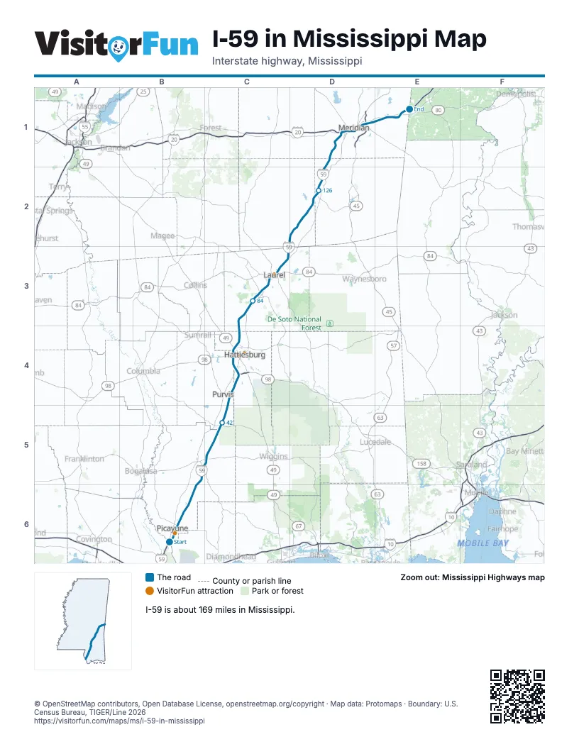
Exits on I-59 in Mississippi
Each exit in mile order, with its grid square.
- Exit 1mile 0, B6
- Exit 4mile 4, B6
- Exit 6mile 6, B6
- Exit 10mile 11, B6
- Exit 15mile 15, B6
- Exit 19mile 19, B6
- Exit 27mile 27, B5
- Exit 29mile 30, C5
- Exit 35mile 35, C5
- Exit 41mile 41, C5
- Exit 51mile 51, C4
- Exit 59mile 58, C4
- Exit 60mile 60, C4
- Exit 65A-Bmile 64, C4
- Exit 65mile 65, C4
- Exit 67Amile 67, C4
- Exit 67Bmile 67, C4
- Exit 69mile 70, C4
- Exit 73mile 72, C4
- Exit 76mile 75, C3
- Exit 78mile 77, C3
- Exit 80mile 79, C3
- Exit 85mile 85, C3
- Exit 88mile 87, C3
- Exit 90mile 90, C3
- Exit 93mile 92, C3
- Exit 95Amile 94, C3
- Exit 95Bmile 94, C3
- Exit 95Cmile 94, C3
- Exit 96Amile 94, C3
- Exit 97mile 96, C3
- Exit 99mile 97, C3
- Exit 104mile 103, C3
- Exit 113mile 112, D2
- Exit 118mile 117, D2
- Exit 126mile 125, D2
- Exit 134mile 132, D2
- Exit 137mile 135, D1
- Exit 142mile 140, D1
- Exit 149mile 146, D1
- Exit 150mile 147, D1
- Exit 151mile 148, D1
- Exit 152mile 149, D1
- Exit 153mile 150, D1
- Exit 154Amile 151, D1
- Exit 154Bmile 152, D1
- Exit 154mile 152, D1
- Exit 156mile 153, D1
- Exit 157Amile 154, D1
- Exit 157Bmile 154, D1
- Exit 160mile 157, D1
- Exit 165mile 162, E1
- Exit 169mile 165, E1
Highways I-59 meets
Each highway it meets and the grid squares where they meet.
- US 11B6, C3, C4, D1, E1
- MS 607B6
- MS 43B6
- MS 53B5
- MS 26C5
- MS 13C5
- MS 589C4
- US 98C4
- MS 198C4
- US 49C4
- MS 42C4
- MS 590C3
- MS 588C3
- US 84C3
- MS 15C3
- MS 528D2
- MS 18D2
- MS 513D2
- I-20D1, E1
- US 80D1, E1
- MS 19D1
- MS 145D1
- MS 493D1
- MS 39D1
- US 45D1
Towns along I-59 in Mississippi
In mile order, with the grid square of each.
- Picayunemile 0, B6
- Nicholsonmile 0, B6
- Hide-A-Way Lakemile 7, B6
- Poplarvillemile 26, B5
- Lumbertonmile 40, C5
- Purvismile 51, C4
- Hattiesburgmile 59, C4
- West Hattiesburgmile 63, C4
- Arnold Linemile 65, C4
- Glendalemile 68, C4
- Mosellemile 79, C3
- Ellisvillemile 83, C3
- Laurelmile 89, C3
- Sandersvillemile 102, C3
- Heidelbergmile 112, D2
- Pachutamile 124, D2
- Meridianmile 145, D1
- Toomsubamile 161, E1
Things to do on the I-59 in Mississippi map
© OpenStreetMap contributors, Open Database License, openstreetmap.org/copyright · Map data: Protomaps · Boundary: U.S. Census Bureau, TIGER/Line 2026















