

Mississippi road map
Natchez Trace Parkway map
The Natchez Trace Parkway has been an All-American Road since 1996, named for its historic and scenic qualities: about 444 miles in Mississippi, Tennessee and Alabama. It meets 58 highways, among them I-20, I-22 and I-55. Towns along it: Nashville-Davidson metropolitan government (balance), Tupelo and Madison.
Open the map (PDF, US Letter)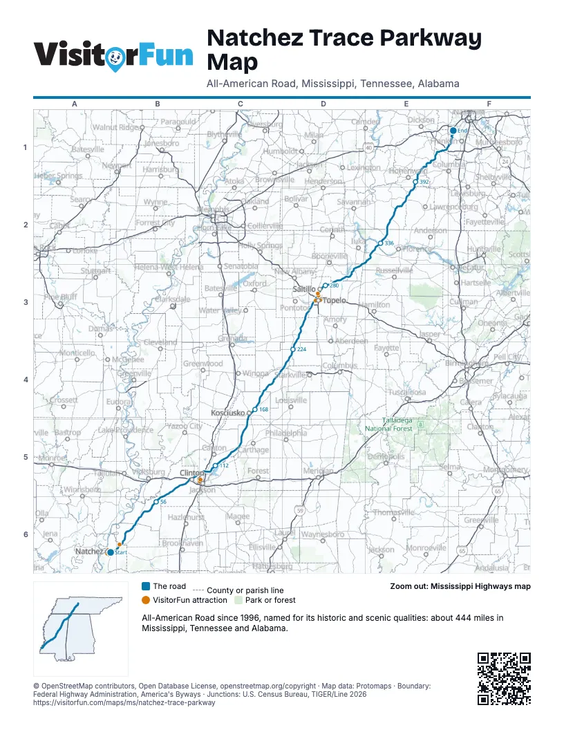
Highways it meets
Each highway it meets and the grid squares where they meet.
- US 98A6
- US 84A6
- US 61B6
- MS 553B6
- MS 552B6
- MS 547B6
- MS 18B6
- MS 27B5
- MS 467B5
- I-20B5
- US 80B5
- US 49B5
- I-55C5
- MS 886C5
- US 51C5
- MS 43C5
- MS 16C5
- MS 429C5
- MS 14C4
- MS 35C4
- MS 407C4
- MS 413C4
- MS 9C4
- US 82D4
- MS 15D4
- MS 46D4
- MS 389D4
- MS 8D3
- MS 32D3
- MS 41D3
- MS 76D3
- US 278D3
- MS 6D3
- MS 178D3
- I-22D3
- US 78D3
- MS 145D3
- US 45D3
- MS 363D3
- MS 371D3
- MS 370D3
- MS 4D3
- MS 25D3
- MS 30D3
- US 72E2
- AL 2E2
- AL 20E2
- TN 13E2
- TN 203E2
- US 64E2
- TN 15E2
- TN 20E1
- US 412E1
- TN 99E1
- TN 50E1
- TN 7E1
- I-840E1
- TN 96F1
Towns along the Natchez Trace Parkway
In mile order, with the grid square of each.
- Natchezmile 0, A6
- Morgantownmile 1, A6
- Port Gibsonmile 38, B6
- Clintonmile 85, B5
- Jacksonmile 92, B5
- Ridgelandmile 96, B5
- Madisonmile 104, C5
- Kosciuskomile 161, C4
- French Campmile 183, C4
- Mathistonmile 207, D4
- Manteemile 221, D4
- Van Vleetmile 244, D3
- Tupelomile 262, D3
- Saltillomile 272, D3
- Kirkvillemile 286, D3
- Dennismile 305, D3
- Collinwoodmile 360, E2
- Nashville-Davidson metropolitan government (balance)mile 442, F1
Things to do on the Natchez Trace Parkway map
© OpenStreetMap contributors, Open Database License, openstreetmap.org/copyright · Map data: Protomaps · Boundary: Federal Highway Administration, America's Byways · Junctions: U.S. Census Bureau, TIGER/Line 2026















