

North Carolina map
Raleigh map
About 499,825 people live here (Census Bureau, 2024 estimate). The sheet's index lists 138 streets; Glenwood Avenue, Capital Boulevard and Northern Wake Expressway cross the most grid squares. Things to do inside the boundary: North Carolina Museum of Art.
Open the map (PDF, US Letter)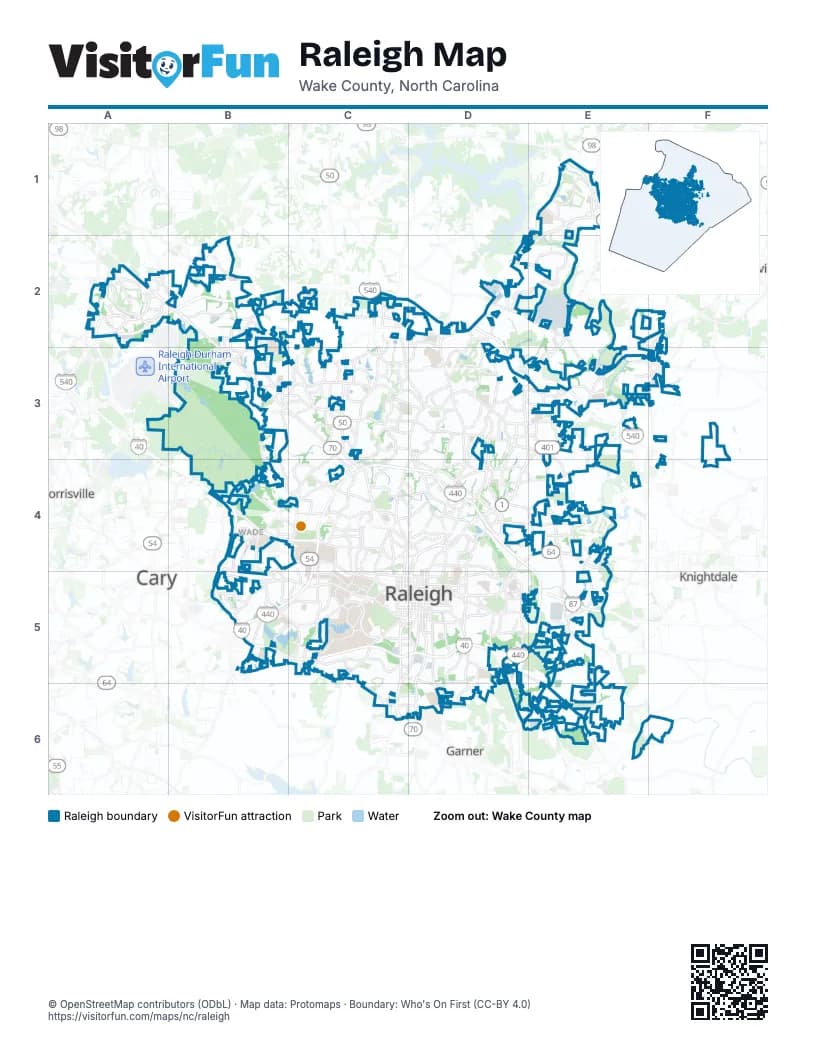
Street index of Raleigh
Each street on the sheet and the grid squares it crosses.
- Falls of Neuse RoadE1, D2, E2, D3
- Old Falls of Neuse RoadE1, E2
- Aviation ParkwayA2
- Brier Creek ParkwayA2
- Glenwood AvenueA2, B2, B3, C3, C4, C5
- Globe RoadA2
- Lumley RoadA2, B2
- Northern Wake ExpresswayA2, B2, D2, D3, E3
- Page RoadA2
- T.W. Alexander DriveA2
- Carpenter Pond RoadB2
- Ebenezer Church RoadB2, B3, B4
- Fairbanks DriveB2
- Farless RoadB2
- Hickory Grove Church RoadB2
- Hickory Grove RoadB2
- Leesville RoadB2, C3
- Pinecrest RoadB2, B3
- Strickland RoadB2, C2, D2
- Westgate RoadB2
- Creedmoor RoadC2, C3, C4
- Lead Mine RoadC2, C3, C4
- Ray RoadC2, C3
- Six Forks RoadC2, C3, D3, D4
- Durant RoadD2, E2
- Honeycutt RoadD2
- Litchford RoadD2, D3
- Raven Ridge RoadD2
- Capital BoulevardE2, D3, E3, D4, E4, D5
- Louisburg RoadE2, F2, E3, D4, E4
- Perry Creek RoadE2, E3
- Forestville RoadF2, F3
- Duraleigh RoadB3, B4, C4
- Lynn RoadB3, C3, D3
- West Millbrook RoadB3, C3
- Millbrook RoadC3, D3
- North Hills DriveC3
- Atlantic AvenueD3, D4
- East Millbrook RoadD3
- North New Hope RoadD3, E3, E4, E5
- Old Wake Forest RoadD3, E3
- Spring Forest RoadD3, E3
- Wake Forest RoadD3, D4, D5
- Fox RoadE3
- Mitchell Mill RoadE3, F3
- Triangle Town BoulevardE3
- Chapel Hill RoadB4, B5
- Dan K Moore FreewayB4, B5, C5, D5
- Dan K. Moore FreewayB4
- Edwards Mill RoadB4, C4, B5
- Hillsborough StreetB4, C4, B5, C5
- Hurricanes HighwayB4, B5
- Raleigh Chapel–Hill ExpresswayB4, C4
- Reedy Creek RoadB4, C4
- Trenton RoadB4
- Trinity RoadB4, C4
- Annapolis DriveC4
- Blue Ridge RoadC4, C5
- Brooks AvenueC4, C5
- Clark AvenueC4, C5
- Dixie TrailC4, C5
- Faircloth StreetC4
- Glen Eden DriveC4
- Gorman StreetC4, C5
- Lake Boone TrailC4
- Lassiter Mill RoadC4, D4
- Oberlin RoadC4, C5
- Saint Marys StreetC4, C5
- Wade AvenueC4, D4
- West Whitaker Mill RoadC4, D4
- Automotive WayD4
- Brentwood RoadD4
- Buffaloe RoadD4, E4
- Crabtree BoulevardD4
- Delway StreetD4
- East Six Forks RoadD4
- East Whitaker Mill RoadD4
- Highwoods BoulevardD4
- New Bern AvenueD4, E4, D5
- New Hope Church RoadD4
- North Blount StreetD4, D5
- North Raleigh BoulevardD4, D5
- Old Louisburg RoadD4
- Raleigh BoulevardD4, D5
- Skycrest DriveD4, E4
- Yonkers RoadD4
- Corporation ParkwayE4
- Avent Ferry RoadB5, C5
- Buck Jones RoadB5
- Cary Towne BoulevardB5
- Claude E. Pope Memorial HighwayB5
- Dillard DriveB5
- East Chatham StreetB5
- Jones Franklin RoadB5
- Thomas Bradshaw FreewayB5, C5, D5
- Tryon RoadB5, C5, C6, D6
- Western BoulevardB5, C5
- Achievement DriveC5
- Centennial ParkwayC5
- Lake Wheeler RoadC5
- Main Campus DriveC5
- Martin Luther King Jr BoulevardC5, D5
- Maywood AvenueC5
- Pullen RoadC5
- South Dawson StreetC5, D5
- South McDowell StreetC5, D5
- South Saunders StreetC5, C6
- South Wilmington StreetC5, D5, C6
- Thistledown DriveC5
- West Edenton StreetC5, D5
- West Lenoir StreetC5, D5
- West Morgan StreetC5, D5
- West Peace StreetC5, D5
- East Edenton StreetD5
- East Lenoir StreetD5
- East Morgan StreetD5
- East Peace StreetD5
- Garner RoadD5, D6
- Hammond RoadD5, D6
- North Dawson StreetD5
- North McDowell StreetD5
- North Person StreetD5
- North Salisbury StreetD5
- North Tarboro StreetD5
- North Wilmington StreetD5
- Poole RoadD5, E5
- Rock Quarry RoadD5, E5, E6
- South Blount StreetD5
- South Person StreetD5
- South Raleigh BoulevardD5
- South Salisbury StreetD5
- South Tarboro StreetD5
- Sunnybrook RoadD5
- South New Hope RoadE5, E6
- Fayetteville RoadC6
- Goldsboro HighwayC6
- East Tryon RoadD6
- Jones Sausage RoadE6
Things to do on the Raleigh map
Places on the map
- 2728 Capital
- 40 East Business Park
- Abbington Ridge
- Abbott's Creek Greenway
- ACC Park
- Addison Reserve
- AE Finley YMCA
- Alexander Place Townhomes
- Alexandria Square
- Alleghany Trail
- Alyson Pond
- Amanda Estates
- Amberfield
- Anderson Forest
- Anderson Heights
- Anderson Hills Apartments
- Anderson Point Park
- Anderson Pointe
- Angus Barn Pond
- Ansleigh
- Apollo Heights
- Arbor at Harrington Grove
- Arden Forest
- Arden Woods Apartment Homes
- Arlington Hills
- Ashborough
- Ashley Park
- Ashley Ridge
- Ashton Hall Townhomes
- Ashton Square
- Ashworth Estates
- Athena Woods
- Athens Drive High School
- Atlantic Springs Apartments
- Augusta Crossing
- Aurum Falls River By Cortland
- Auston Grove Apartment Homes
- Autumn Ridge Apartment Homes
- Aventon Nora
- Avera Place Condominiums
Next to Raleigh
- Cary
- Garner
- Knightdale
- Morrisville
- Rolesville
- Wake Forest
© OpenStreetMap contributors (ODbL) · Map data: Protomaps · Boundary: Who's On First (CC-BY 4.0)